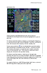


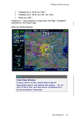
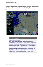
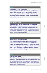


IFD500 Series Pilot Guide
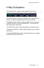
Map Subsystem
4-7
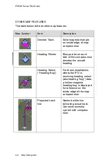
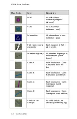
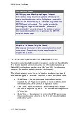
Map Symbol
Item
Description
Single Low
Obstacle
200’ AGL up to 1000’
AGL (blue)
Grouping of low
obstacles
2 or more low obstacles
(200’ AGL up to 1000’
AGL) within 1 nm of each
other (blue)
Single high
obstacle
1000’ AGL or higher
(blue)
Grouping of high
obstacles
2 or more high obstacles
(1000’ AGL or higher)
within 1 nm of each other
(blue)
Towered airport,
hard
Towered airport,
soft
Towered airport,
water
If runway orientation is
known, they are also
depicted on the airfield
symbol (blue with white
runway)
Non-towered
airport, hard
Non-towered
airport, soft
Non-towered
airport, water
If runway orientation is
known, they are also
depicted on the airfield
symbol (magenta)
Summary of Contents for IFD510
Page 1: ......
Page 140: ...IFD500 Series Pilot Guide 3 50 FMS Subsystem Weather Data on Info Tab Info Tab Nearby Navaids ...
Page 150: ...IFD500 Series Pilot Guide 3 60 FMS Subsystem User Waypoint Airfield Naming Example ...
Page 156: ......
Page 180: ...IFD500 Series Pilot Guide 4 24 Map Subsystem ADS B Lightning Coverage Area Shadow ...
Page 252: ...IFD500 Series Pilot Guide 5 16 Aux Subsystem Trip Statistics Calculator ...
Page 460: ...IFD500 Series Pilot Guide 7 82 General Bluetooth pairing pairing code ...


