


The default datum for your multifunction display is WGS1984. If
this is not the datum used by your paper charts, you can change
the datum for your multifunction display, using the
MENU > Chart
Setup > Datum
menu item.
When you change the datum for your multifunction display, the
chart grid will subsequently move according to the new datum, and
the latitude/longitude of the cartographic features will also change
accordingly. Your multifunction display will attempt to set up any
GPS receiver to the new datum, as follows:
• If you have a Raymarine GPS receiver using SeaTalk or
SeaTalk
ng
, it will automatically correlate each time you change the
datum on the multifunction display.
• If you have a Raymarine GPS receiver using NMEA0183, or a
third-party GPS receiver, you must correlate it separately.
It may be possible to use your multifunction display to correlate an
NMEA0183 GPS receiver. Go to
MENU > GPS Status
. If the datum
version is displayed, it may be possible to change it by selecting the
OTHER SETUP
softkey and choosing the appropriate datum. If the
NMEA0183 GPS receiver does NOT state which datum it is using,
you must select the NMEA0183 GPS datum using the
MENU > GPS
Status > Other Setup > NMEA0183 GPS Datum
menu item.
Note:
Raymarine recommends that you check the displayed
vessel position in the chart application against your actual
proximity to a known charted object. A typical GPS has an
accuracy of between 5 and 15 m.
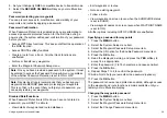
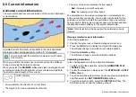
Chart cards overview
Chart cards provide additional cartographic information.
Obtain detailed cartographic information for the area that
you navigate using Navionics® chart cards. To check the
current availability of Navionics chart card types, please
visit
or
. The amount of
cartographic detail shown varies for different areas and for different
scales. The chart scale in use is indicated in the status bar — the
number represents the distance in nautical miles horizontally across
the chart.
You can remove and insert chart cards while a chart is displayed
provided that you follow the correct procedure. The chart information
is retained on-screen until the chart application redraws the screen;
for example, when you pan outside the current area, or use the
Range
button to change the chart scale.
Caution: Care of chart cards
To avoid irreparable damage to and/or loss of data
from chart cards:
• Ensure that chart cards are fitted the correct way
around. DO NOT try to force a card into position.
• DO NOT save data (waypoints, routes, and so on)
to a chart card, as the charts may be overwritten.
• DO NOT use a metallic instrument such as a
screwdriver or pliers to remove a chart card.
• Safe removal. Use the Remove Card menu option
before removing the chart card.
Chart compatibility
Your multifunction display is supplied with embedded Navionics
electronic charts. You can also insert Navionics chart cards to get
enhanced chart detail and additional chart features.
Your multifunction display is compatible with the following Navionics
chart cards:
• Silver
• Gold
• Gold+
Using the chart
71
Содержание E-Series
Страница 1: ......
Страница 2: ......
Страница 4: ......
Страница 16: ...16 E Series Widescreen User reference...
Страница 42: ...42 E Series Widescreen User reference...
Страница 148: ...148 E Series Widescreen User reference...
Страница 164: ...164 E Series Widescreen User reference...
Страница 204: ...204 E Series Widescreen User reference...
Страница 214: ...214 E Series Widescreen User reference...
Страница 224: ...224 E Series Widescreen User reference...
Страница 228: ...228 E Series Widescreen User reference...
Страница 240: ...240 E Series Widescreen User reference...
Страница 252: ...252 E Series Widescreen User reference...
Страница 260: ......


