


12
User Manual
1.2 FEATURES
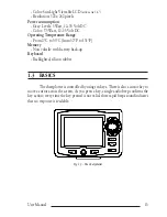
The chartplotter is a computer specifically designed for nautical use but, more
precisely, to ease and speed up all calculations, which so far have been done manu-
ally. If connected to a positioning instrument, the chartplotter displays the current
position, the speed, and the heading of the boat and its Track. The user information
like Waypoints, Marks and Tracks can then be stored on a User C-CARD and can be
recalled at any time. On the screen are shown navigation data and cartographic in-
formation obtained from electronic charts of
C-MAP
C-CARD.
When the package containing the chartplotter is first opened, please check it
for the following contents (if any parts are missing contact the dealer the chartplotter
was purchased from):
•
Quick disconnect bracket and its protective cover
•
Chartplotter's protective cover
•
User Manual
Note
FOR COLOR CHARTPLOTTER
Fuse 2 Amp. + fuseholder.
Note
FOR CHARTPLOTTER WITH EXTERNAL GPS RECEIVER
Tha package contains the following parts too: Flush mounting kit; Smart DGPS WAAS Receiver
with cable 15 mt/45 feet.
C-MAP
C-CARD (cartography data cards) are available through your local
dealer. For additional information on C-MAP Cartography visit web site at www.c-
map.com.
1.2.1 SPECIFICATIONS
1.2.1.1Main Characteristics
Recordable Individual points
•
User Points
: 500
•
Type of User Points
: 16
Routes
•
Routes
: 25
•
Max User Points per Route
: 100
Tracking
•
Tracks
: 2
•
Points per Track
: 1000
•
Step by Distance
: 0.01, 0.05, 0.1, 0.5, 1, 2, 5, 10 Nm
Содержание Compact 7 Plus
Страница 14: ...16 User Manual...
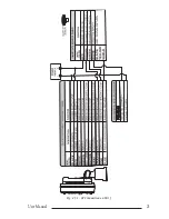
Страница 19: ...21 User Manual Fig 2 5 1 GPS Connection on Port 3...
Страница 50: ...52 User Manual...
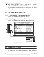
Страница 87: ...89 User Manual 6 For the Technician 6 1 DIMENSIONS Fig 6 1 EXCALIBUR models Dimensions...
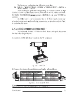
Страница 92: ...94 User Manual Fig 6 4a GPS Connection on Port 3 for chartplotter with external GPS receiver...
Страница 98: ...100 User Manual...