13
User Manual
•
Step by Time
: 1, 5, 10, 30 Sec, 1, 5, 10 Min
Cartographic Functions
•
Detailed Map by using
C-MAP
C-CARD
•
Coordinates System (ddd mm ss, ddd mm.mm, ddd mm.mmm, UTM, OSGB, TD)
•
Map Datum
•
Display Mode (Full, Simple, Fishing, Low, Custom)
•
Marine
Names, Buoys ID, Nav-Aids, Light Sectors, Attention Areas, Tides & Currents,
Seabed Type, Ports & Services, Tracks & Routes, Underwater Objects
•
Depth
Depth Areas, Depth Areas Min/Max, Rocks Min/Max
•
Land
Lan Elevation values, Roads, POIs
•
Chart
Lat/Lon Grid, Chart Boundaries, Value-Added data
Map Menu
•
Zoom Type
•
Fonts & Symbols
•
Perspective View
•
Live Nav-Aids
•
Map Orientation (North, Head, Course)
•
Mixing Levels
•
Safety Status Bar
•
Palette
•
Currents Prediction
Fix Functions
•
Fix Correction (manual and automatic)
•
Position Filter
•
Speed Filter
•
Dead Reckoning
•
Screen Amplifier
•
Reset Total and Partial Trip
•
Rolling Road Scale
•
Fix Datum
•
Compass Calibration
•
Bearings True and Magnetic
•
Variation user selectable
•
Course Vector
•
Static Navigation
Содержание Compact 7 Plus
Страница 14: ...16 User Manual...
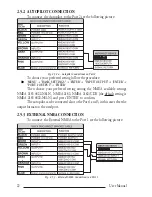
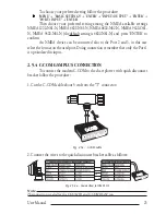
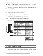
Страница 19: ...21 User Manual Fig 2 5 1 GPS Connection on Port 3...
Страница 50: ...52 User Manual...
Страница 87: ...89 User Manual 6 For the Technician 6 1 DIMENSIONS Fig 6 1 EXCALIBUR models Dimensions...
Страница 92: ...94 User Manual Fig 6 4a GPS Connection on Port 3 for chartplotter with external GPS receiver...
Страница 98: ...100 User Manual...

