


113
User Manual
Light Sectors ......................................... 43
line pattern ............................................ 69
Loading File .......................................... 72
LOG .................................................... 103
Longitude ............................................ 103
Loran ................................................... 103
M
Magnetic Deviation ............................. 103
Magnetic Variation .............................. 103
Man OverBoard .................................... 18
Map Datum ........................................... 83
Map Menu ...................................... 13, 38
Map Orientation ............................. 39, 83
Map Presentation ................................. 45
Marine Settings ..................................... 24
Mark ............................................. 63, 103
MAX ...................................................... 37
Memory ................................................. 15
Mixing Levels ........................................ 40
MOB ............................................... 18, 50
Modem Test .......................................... 99
Moving A-B-C-D .................................... 68
Moving Mark ......................................... 63
Moving Waypoint .................................. 56
N
Names .................................................. 42
Natural Features ................................. 103
Nav-Aids ........................................ 40, 43
Navigate ....................................... 17, 103
Navigate menu ..................................... 82
Navigating on A-B-C-D .................. 36, 68
Navigation ............................................. 34
Navigation Data Page ........................... 30
Navigation Speed ................................. 34
Nearest Services .................................. 49
NMEA .................................................... 22
NMEA WPL & RTE ............................... 62
NMEA-0183 ........................................ 103
O
Obstructions ......................................... 50
OSGB .......................................... 82, 104
Other Map Configurations .................... 42
Output Port ........................................... 35
P
Pair ........................................................ 82
Palette ................................................... 38
Perspective View .................................. 38
Phisical Characteristics ........................ 14
Pictures ............................................... 103
POIs ...................................................... 44
Port 1/Port 2/Port 3 Input ..................... 32
Port 1/Port 2/Port 3 NMEA Output ....... 33
Port 1/Port 2/Port 3 Output ................... 33
Port Info ....................................... 47, 104
Ports & Services .......................... 43, 104
Position Filter ........................................ 81
problems ............................................... 96
R
RAM Clear ............................................ 98
RAM Menu ............................................ 98
RAM Test .............................................. 98
Receiver ................................................ 12
removing ............................................... 91
Removing C-CARD .............................. 25
Reset Partial Trip .................................. 83
Reset Total Trip .................................... 83
Restart GPS ......................................... 33
Reversing route ............................. 61, 62
Rivers & Lakes ..................................... 44
Roads ................................................... 44
Rocks < ................................................. 44
Rocks > ................................................. 44
Rolling Road Page ................................ 30
Rolling Road Scale ............................... 83
route ...................................... 54, 60, 104
Route Name ......................................... 62
Route Report ........................................ 61
RTCM .................................................. 104
S
Safety Status Bar ................................. 40
Saving File ............................................ 71
screen display ....................................... 27
Seabed Type ........................................ 43
Selecting active Track .......................... 69
Selecting Route .................................... 60
Selecting route ...................................... 62
Selecting track line pattern ................... 69
Send & Receive Marks/Routes ............ 34
Send/Receive Route ............................. 62
Serial Ports ........................................... 99
Setup menu .......................................... 79
Simulation Mode ................................... 86
Simulator ............................................... 86
size ........................................................ 14
Smart DGPS WAAS Receiver ........... 107
SOG .................................................... 104
Specifications ....................................... 12
Speed ..................... 32, 62, 81, 86, 104
Speed Filter .......................................... 81
Speed Over Ground ........................... 104
Содержание Compact 7 Plus
Страница 14: ...16 User Manual...
Страница 19: ...21 User Manual Fig 2 5 1 GPS Connection on Port 3...
Страница 50: ...52 User Manual...
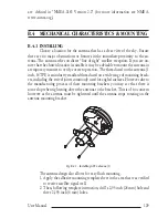
Страница 87: ...89 User Manual 6 For the Technician 6 1 DIMENSIONS Fig 6 1 EXCALIBUR models Dimensions...
Страница 92: ...94 User Manual Fig 6 4a GPS Connection on Port 3 for chartplotter with external GPS receiver...
Страница 98: ...100 User Manual...