Troubleshooting Autorouting
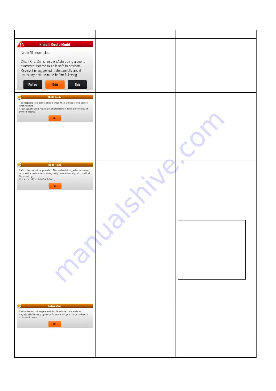
The information below details the warnings that can be displayed when using
Autorouting
, a description of
what the warning means and actions to be taken to correct the issue.
Warning message
Description
Resolution
Autorouting
has completed successfully
The Route maybe followed AFTER it
has been reviewed to ensure that the
generated route is safe for your vessel
to follow.
Autorouting
has completed successfully,
however the route passes close to areas
where extra caution is advised (e.g. a
charted buoy).
The caution areas will be between
waypoints that have been assigned
caution symbol.
The route must be reviewed as follows:
• Identify any waypoints using the
caution symbol (these will be in sets of
2), check between the caution symbols
to identify the reason for the caution.
• If possible move the waypoint(s) to
avoid the hazard.
• Review all route legs and their
waypoints to ensure appropriate
before following the route.
The start and or end point of the route
does not meet the minimum safe values
specified in the
Boat Details
settings.
The start and end waypoints will be
created and joined with a straight
route leg, however there will be no
automatically generated waypoints and
the waypoint symbols will be changed to
caution symbols.
Perform the following checks:
• Check that the values specified in the
Boat Details
settings are correct.
• Using the context menu check the
Chart Objects
menu at the exact
location of the start and or end points
to establish if the
Depth range min
value
meets you
Minimum Safe
Depth
.
Note:
– If no minimum value for depth is
available at the desired location
Autorouting
will assume a
minimum depth of 0 feet.
–
Autorouting
adds its own
safety margin of 0.8 m or 20%
of the specified
Minimum Safe
Depth
which ever is greater.
• Check for any other hazards that
would prevent
Autorouting
from
generating a route.
There is insufficient data available on the
cartography to generate the route,
The start and end waypoints will be
created, however there will be no
automatically generated waypoints and
the waypoint symbols will be changed to
caution symbols.
• Insert compatible cartography
(
Navionics® Updates
or
Navionics®
Platinum
TM
+
)
• Update existing cartography
Note:
There may be certain areas
where sufficient details are not
yet available even on the latest
cartography.
224
a Series / c Series / e Series
Содержание a125
Страница 2: ......
Страница 6: ......
Страница 16: ...16 a Series c Series e Series ...
Страница 43: ...13 GPS receiver 14 Thermal camera 15 Wireless connection Planning the installation 43 ...
Страница 50: ...50 a Series c Series e Series ...
Страница 82: ...82 a Series c Series e Series ...
Страница 114: ...114 a Series c Series e Series ...
Страница 120: ...120 a Series c Series e Series ...
Страница 186: ...186 a Series c Series e Series ...
Страница 187: ...Chapter 13 Man Overboard MOB Chapter contents 13 1 Man overboard on page 188 Man Overboard MOB 187 ...
Страница 190: ...190 a Series c Series e Series ...
Страница 193: ...Chapter 15 Fuel manager Chapter contents 15 1 Fuel manager overview on page 194 Fuel manager 193 ...
Страница 208: ...208 a Series c Series e Series ...
Страница 230: ...230 a Series c Series e Series ...
Страница 320: ...320 a Series c Series e Series ...
Страница 340: ...340 a Series c Series e Series ...
Страница 364: ...364 a Series c Series e Series ...
Страница 420: ...420 a Series c Series e Series ...
Страница 424: ...424 a Series c Series e Series ...
Страница 434: ...434 a Series c Series e Series ...
Страница 459: ......
Страница 460: ...www raymarine com ...


