


Garmin G1000 NXi Cockpit Reference Guide for the da62
190-02622-00 Rev. A
95
Hazard avoidance
Flight
Instruments
EIS
Nav/Com/
XPDR/Audio
Flight
Management
Hazar
d
Avoidance
AFCS
Additional
Featur
es
Annun/Alerts
Appendix
Index
Flight
Instruments
EIS
Nav/Com/
XP
d
R/
a
udio
Flight
Management
Hazar
d
avoidance
a
FCS
a
dditional
Featur
es
a
bnormal
o
per
ation
a
nnun/
a
lerts
a
ppendix
Index
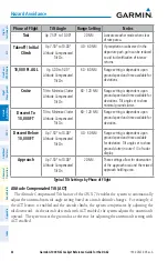
5)
Turn the large
FMS
Knob or press the
ENT
Key to scroll through product selections.
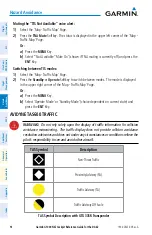
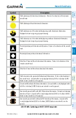
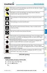
• Terrain display
– Selects the display of topographical terrain, relative terrain, or no
terrain, and selects the maximum map range at which terrain is shown.
• obstacle data
– Turns the display of obstacle data on or off and sets maximum range at
which obstacles are shown.
6)
Turn the small
FMS
Knob to scroll through options for each product (On/Off, range
settings).
7)
Press the
ENT
Key to select an option.
8)
Press the
FMS
Knob or
CLR
Key to return to the ‘Map - Navigation Map’ Page with the
changed settings.
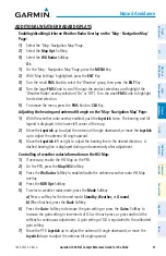
Terrain Page
displaying the terrain page:
1)
Turn the large
FMS
Knob to select the Map Page Group.
2)
Turn the small
FMS
Knob
to select the 'Map - Terrain Proximity' Page or 'Map -Terrain-
SVT' Page.
Showing/hiding aviation information on the terrain page:
1)
Press the
MENU
Key.
2)
Select ‘Show Aviation Data’ or ‘Hide Aviation Data’ (choice dependent on current state)
and press the
ENT
Key.
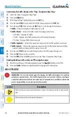
VERTICaL SITUaTIoN dISPLay (VSd) TERRaIN
Enabling/disabling the Vertical Situation display (VSd):
1)
Select the ‘Map - Navigation Map’ Page.
2)
Press the
Map opt
Softkey.
3)
Press the
Inset
Softkey.
4)
Press the
VSd
Softkey to enable or disable the VSD.
or
:
1)
Select the ‘Map - Navigation Map’ Page.
2)
Press the
MENU
Key.
3)
Select ‘Show VSD’ or ‘Hide VSD’ (choice dependent on current state) and press the
ENT
Key.
Enabling/disabling VSd Relative Terrain on the ‘Map - Navigation Map’ Page (when
VSd is enabled):
1)
Select the ‘Map - Navigation Map’ Page.
2)
Press the
Map opt
Softkey.
3)
Press the
TER
Softkey. Each selection cycles though an option displayed in cyan: Off
(disables terrain), Topo (to show topographical data) or REL (to show relative terrain).
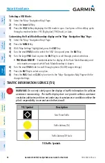
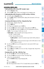
Содержание G1000 NXi
Страница 1: ...Cockpit Reference Guide Diamond DA62 System Software Version 2056 10 or later...
Страница 2: ......
Страница 4: ......
Страница 14: ...Garmin G1000 NXi Cockpit Reference Guide for the DA62 190 02622 00 Rev A Warnings Cautions Notes Blank Page...
Страница 16: ...Garmin G1000 NXi Cockpit Reference Guide for the DA62 190 02622 00 Rev A Software License Agreement Blank Page...
Страница 18: ...Garmin G1000 NXi Cockpit Reference Guide for the DA62 190 02622 00 Rev A 14 Record of Revisions Blank Page...
Страница 219: ......