


GPS Chart Plotters
Page 51
R
5. MAX CARTOGRAPHY OVERVIEW
5.0
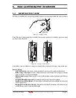
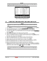
INSERTING THE C-CARD
Hold the C-CARD by the long inclined side so that you can see the C-MAP B
Y
J
EPPESEN
label.
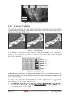
Figure 5.0 - Inserting C-CARD
Open the door, gently push the C-CARD into the slot: push the C-CARD in as far as it will
go, then close the door.
Figure 5.0a - Inserting C-CARD (Details)
C-MAP B
Y
J
EPPESEN
MAX is a major evolution of the product technology. Key points are:
Data Features
· ISO Certification
(electronic chart production process with quality certification)
· Extra Large Coverage
(all the C-Map electronic chart detail and a huge coverage
without having to change cartridge)
· Official data source (data based on use of official data sources Hydrographic Offices
Release)
· Detailed World Background
(worldwide background chart with details)
· Depths & Land Elevations (color shading of sea depth and land altitude for improved
chart appearance)
· Bathymetric & Spot Soundings
(Data Base with depth and bathy information for an
extraordinary view of the seabed depth)
Summary of Contents for CP180
Page 1: ...CP180 CP180i CP300 CP300i Owner s Manual Color GPS Chart Plotters R ...
Page 4: ...Page 6 GPS Chart Plotters R ...
Page 12: ...Page 14 GPS Chart Plotters R ...
Page 38: ...Page 40 GPS Chart Plotters R ...
Page 48: ...Page 50 GPS Chart Plotters R ...
Page 60: ...Page 62 GPS Chart Plotters R ...
Page 68: ...Page 70 GPS Chart Plotters R ...
Page 76: ...Page 78 GPS Chart Plotters R ...
Page 80: ...Page 82 GPS Chart Plotters R ...
Page 108: ...Page 110 GPS Chart Plotters R ...
Page 118: ...Page 120 GPS Chart Plotters R ...
Page 120: ...Page 122 GPS Chart Plotters R ...
Page 126: ...Page 128 GPS Chart Plotters R ...
Page 130: ...Page 132 GPS Chart Plotters R ...


