


91
User Manual
Compute Correction
Corrects fixes from the positioning instrument. By placing the cursor on the ship's real position and
selecting this option, the error is calculated and internally memorized for appropriate correction, but
not applied.
'MENU' +
"ADVANCED SETTINGS" + 'ENTER' + "FIX " + 'ENTER' + "COMPUTE CORRECTION" + 'ENTER'
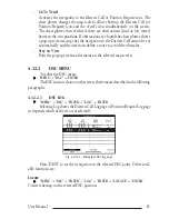
Coordinate System
Sets your preferred Coordinate System among ddd mm ss, ddd mm.mm, ddd mm.mmm, UTM, OSGB,
TD. The default setting is ddd mm.mmm.
'MENU' +
"ADVANCED SETTINGS" + 'ENTER' + "NAVIGATE" + 'ENTER' + "COORDINATE
SYSTEM" + 'ENTER'
Correction
To compute fix error in automatic mode, place cursor on ship's real position and then follow the
procedure (compute correction). It is also possible to compute the fix error in manual mode (correction
offset). Once you computed the error, you can turn the fix correction On or Off.
Correction Offset
Manual correction of fix position.
'MENU' +
"ADVANCED SETTINGS" + 'ENTER' + "FIX" + 'ENTER' + "CORRECTION OFFSET" +
'ENTER'
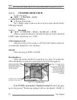
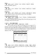
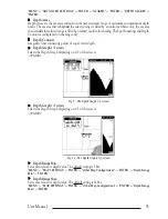
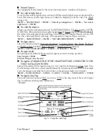
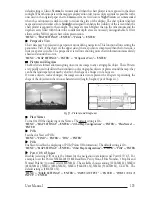
Course Vector
The Course Vector is a graphical indication of the direction in which the Vessel is heading. The Course
Vector origin is the vessel’s position so the time line movement is synchronized with the vessels Icon.
Course Vector course is given by the value of COG (Course Over Ground) and its length is propor-
tional to the SOG (Speed Over Ground). This option disables (Off) or sets time as : 2, 10, 30 min, 1, 2
hours, Infinite. The default setting is Infinite.
'MENU' +
"BASIC SETTINGS" + 'ENTER' + "COURSE VECTOR" + 'ENTER'
Cross Track error = XTE
The distance from the ship's present position to the closest point on a line between the origin and
destinations Waypoints of the navigation leg being travelled.
CTS = Course To Steer
The optimum direction the boat should be steered in order to efficiently make headway back to the
courseline while also proceeding toward the destination Waypoint.
Cultural Features
Any man-made topographic feature as built-up area, buildings, roads, ...
Current
Non-periodical movement of sea-water, generally horizontal, due to many causes such as different
temperatures and prevalent winds. Some may be temporary, others permanent.
Current Route
Selects the active route.
'MENU' +
"ADVANCED SETTINGS" + 'ENTER' + "ROUTE" + 'ENTER' + "CURRENT ROUTE" +
'ENTER'
Currents Prediction
It is possible to see the variation of the Tidal arrows on the selected area at any given time.
'MENU' + "MAP SETTINGS" +'ENTER' + "Currents Prediction" + 'ENTER'
Cursor Control
Enables (On)/disables (Off) the cursor control. The default setting is Off.
'MENU' +
"ADVANCED SETTINGS" + 'ENTER' + "SIMULATION" + 'ENTER' + "CURSOR CON-
TROL" + 'ENTER'
Summary of Contents for MAGNUM PLUS
Page 8: ...10 User Manual ...
Page 12: ...14 User Manual ...
Page 22: ...24 User Manual ...
Page 46: ...48 User Manual ...


