


71
User Manual
stored in its memory and the navigation is started.
The information sent by the Master consists of the following values:
- Navigation mode (To Single Destination / to a Route )
- Route Name (*)
- Destination ID
- Destination Position
- Next Waypoint ID (*)
- Range from Destination to next Waypoint (*)
- Bearing from Destination to next Waypoint (*)
- Route Length (*)
- Distance from Destination to Last Route Waypoint (*)
- Remaining Route Legs (*)
- Planned Cruising Speed
- Average Fuel Consumption
- Initial Fuel Load
C-Link navigation data can refer to:
- Single Destination navigation
- Route Following navigation.
Values identified by (*) are sent only for Route Following navigation.
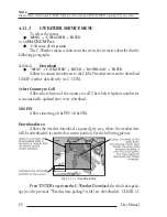
The Destination Icon, Navigation leg (Fix Position to Destination), the Next
Waypoint Icon and all other relevant C-Link navigation data will be shown on the
Slave chart plotter. Any variation of the C-Link navigation data on the Master will
be communicated to the Slave so to keep data aligned on both devices.
4.8.1.2
C-Link serial connection
The two chart plotters should be connected via serial ports. Any of the avail-
able ports can be used, the software will recognize automatically the serial ports
used. A typical connection is as follows:
CP1
CP2
TX
—————> RX
RX
<————— TX
GND <————> GND
4.8.1.3
Master Chart Plotter
Operating mode
To select the Master mode (Primary Station) follow the procedure:
'MENU' + "BASIC SETTINGS" + 'ENTER' + "INPUT/OUTPUT" + 'ENTER' +
"C-LINK" + 'ENTER' + "Primary Station" + 'ENTER'
Summary of Contents for MAGNUM PLUS
Page 8: ...10 User Manual ...
Page 12: ...14 User Manual ...
Page 22: ...24 User Manual ...
Page 46: ...48 User Manual ...