


Chapter 6 Map operation
MDC-7000/7900 Series
0093169010-10
6-4
6.4
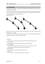
COAST LINE
This function is to let user generate up to 10 coast lines with up to 100 points each to mark important
areas of navigation, such as danger zone areas or navigation channels etc. Coast line can be setup by
inputting Lat/Lon information for each point or using cursor and ENT key.
It is displayed one by one or all.
1
Press MENU key to display
“Menu”.
Select [MAP] => [COAST LINE] =>
COAST LINE: Select the number of the coast line to display. (ALL, 1 to 10, OFF)
ALL: Display all ten coast line.
1 to 10: Display the coast line of selected number.
OFF: Don
’t display coast line.
EDIT:
Create coast line. (CURSOR, BLOCK NUMBER)
MOVE: Change the position. (CURSOR, BLOCK NUMBER)
ADD:
Insert a position data. (CURSOR, BLOCK NUMBER)
DELETE: Delete a position data. (CURSOR, BLOCK NUMBER)
CLEAR: Clear a selected block number coast line data.
How to edit
(1) CURSOR OPERATION
1
Press MENU key to display
“Menu”.
Select [MAP] => [COAST LINE] => [EDIT] => [CURSOR] => select [1 to 10] => [GO] and press
ENT key.
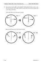
2
Move cursor to first input position, then press ENT key. No.1 mark is displayed on the display and
numerical data is shown at coast line info area.
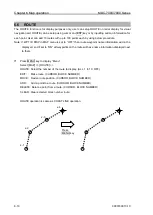
3
Move cursor to second input position, then press ENT key. No.2 mark is displayed, and a line is
generated from No.1 to No.2.
Edit of LAT/LON data, color setting
and delete function can be operated
directly using cursor with trackball in
this info area.
x-1
x-2
x-1
Summary of Contents for MDC-7010
Page 1: ......
Page 2: ......
Page 144: ... This page intentionally left blank ...
Page 170: ... This page intentionally left blank ...
Page 176: ... This page intentionally left blank ...
Page 192: ... This page intentionally left blank ...
Page 234: ......


