background image

78

Down Imaging Sonar

U

NDERSTAND THE

D

OWN

I

MAGING

V

IEW

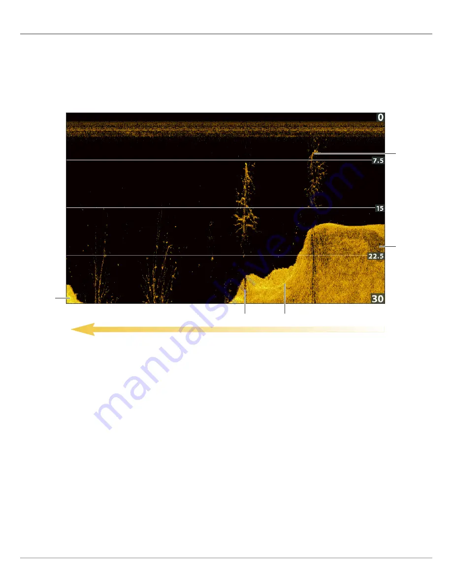
The images you see on the Down Imaging display are produced using sonar technology. Each time the unit pings, a strip of data
representing all the echoes received by the transducer are put together on the display to form the image that you see. Like traditional
2D Sonar, the sonar history scrolls left across the screen. 

Down Imaging beams “illuminate” the bottom contour, structure, and fish. The beams are wide (side to side) but very thin from front
to back.

Use the light and dark parts of the display to interpret the objects under your boat as follows: 

Dark shades

represent soft returns (mud, sand) or descending terrain. 

Light shades 

represent denser terrain (timber, rocks) or rising terrain. A very hard bottom may appear as white on the display. 

White Streaks

or 

Clouds

may represent fish on the display.

Shadows 

are not caused by light but by the lack of a sonar return. Objects standing on the bottom cause a sonar shadow to

appear on the display. The longer the shadow, the taller the object. Fish may also cast shadows. You can use the shadow to
interpret where the fish or object is located in relation to the bottom.

Sonar History — Historical returns scroll left across the view.

Down Imaging View

light shades

shadow

light shades

dark shades

white 
streaks/clouds

Summary of Contents for HELIX 5 G2 SERIES

Page 1: ...HELIX 5 AND HELIX 7 G2 Series Operations Manual 532509 1EN_A...

Page 2: ...ING Do NOT leave the control head microSD card slot cover open The slot cover should always be closed to prevent water damage to the unit WARNING Do not travel at high speed with the unit cover instal...

Page 3: ...or recycling and recovery of waste EEE Johnson Outdoors Marine Electronics Inc will mark all EEE products in accordance with the WEEE Directive It is our goal to comply in the collection treatment rec...

Page 4: ...Display a Down Imaging View On Screen 77 Understand the Down Imaging View 78 Customize the Down Imaging View 79 Adjust Settings While you Fish 82 Review Down Imaging History and Zoom In Zoom Out 86 N...

Page 5: ...g 179 Record your Custom Map 182 Stop Recording 184 Correct Data 184 Display Hide your Custom Map 185 Adjust the Map Display Settings 186 Manage your Control Head 190 Update Software 195 Maintenance 1...

Page 6: ...6...

Page 7: ...and keep your software up to date Visit our Web site at humminbird com to set up an account update control head and accessory software and purchase additional equipment Also see Update Software in th...

Page 8: ...app 5 Open the Humminbird manual Download the Manual to your PC 1 Download the free Adobe Acrobat Reader software from http get adobe com reader and install it on your PC 2 Go to our Web site at humm...

Page 9: ...9 Using the Manual search for key words Ctrl F bookmarks panel Introduction...
Page 10: ...section are a one time set up and other settings such as checking the GPS reception you will use each time you hit the water Power On Follow the instructions below to power on your Humminbird control...

Page 11: ...ed to the control head Normal will be selected automatically and your control head can be used on the water Simulator To learn how to use your control head select Simulator You can save menu settings...

Page 12: ...ilities of the unit When Max Depth is set to match your water maximum depth the control head will not attempt to acquire sonar data below that depth so more detail will be shown on the display Side Im...

Page 13: ...to be detected Unconnected If an accessory is listed as Unconnected check the cable and power connections to con rm they are secure and powered on Review the installation guide that was included with...

Page 14: ...the satellite number and signal strength bar GPS Fix Type reported as No Fix 2D Fix 3D Fix or Enhanced An Enhanced Fix has been augmented using information from WAAS EGNOS or MSAS HDOP the Horizontal...

Page 15: ...based on the menu setting See Adjust Sonar Display Settings for more information Low Battery Alarm The alarm will be triggered when the input battery voltage is equal to or less than the menu setting...

Page 16: ...l Sounds or Alarms Only Change the Alarm Tone Select the Alarms tab Alarm Tone Change the User Mode The User Mode determines how many menu options are displayed in the menu system Select Normal to see...

Page 17: ...e POWER key 2 Select Light 3 Adjust the Backlight setting from Dim to 10 brightest Start Standby Mode To conserve power while the control head is not in use start Standby mode 1 Press the POWER key 2...

Page 18: ...18 HELIX CONTROL HEAD VIEW MENU EXIT HELIX 5 SONAR G2 and HELIX 5 DI G2 HELIX 7 G2 Series Models with GPS The Control Head...

Page 19: ...ursor Control key to move the cursor on the view To move the cursor diagonally press in between the arrows MARK KEY Press the MARK key to save a waypoint at the boat position If the cursor is active p...

Page 20: ...d Recordings CAUTION Before the control head software is updated or restored to system defaults export your navigation data see Update Software Insert a microSD Card 1 Remove the microSD card slot cov...

Page 21: ...21 Removing the Card Slot Cover Installing a microSD Card magnified view notch facing down The Control Head...

Page 22: ...ress Menu is displayed because the Sonar View is displayed on the screen Open the X Press Menu 1 Press the VIEW key repeatedly until the view you want is displayed on screen 2 Press the MENU key once...

Page 23: ...a Menu 1 Press the RIGHT or LEFT Cursor keys 1 Press the DOWN or UP Cursor keys Change a Menu Setting Use the Cursor Control key to change menu settings or start an action When you change a menu setti...

Page 24: ...ow on it press the RIGHT Cursor key to start the action or open the submenu Tips for Using the Menu System You can move through the menu system quickly using the following tips Start an Action or Open...

Page 25: ...e set to Advanced for the selected menu to be shown If you do not see the menu in the system change the User Mode to Advanced Change the User Mode 1 Main Menu Press the MENU key twice 2 Select the Set...

Page 26: ...on your control head are determined by the model you ve purchased and the connected transducer Display a View from the Views X Press Menu 1 Press and hold the VIEW key 2 Select a view category Press...

Page 27: ...IEW key only your favorite views are displayed on the screen Show Hide a View 1 Main Menu Press the MENU key twice 2 Select the Views tab 3 Select a view 4 Select Hidden or Visible Hide Sonar Views If...

Page 28: ...tely 1 Main Menu Press the MENU key twice Select the Setup tab 2 Select Digital Readouts 3 Select one of the following options Show Hide Digital Readouts on the Side Imaging View If you have Digital R...

Page 29: ...29 Views Digital Readouts with Overlay Selected Sonar View temperature depth speed Digital Readouts with Overlay Selected Chart View Course Over Ground COG Distance to Go DTG speed...

Page 30: ...played during navigation 1 Main Menu Advanced User Mode Press the MENU key twice Select the Setup tab 2 Select Select Readouts or Select Nav Readouts Press the RIGHT Cursor key 3 Select a readout wind...

Page 31: ...int on the route ETA Estimated Time of Arrival The estimated time of arrival to the next waypoint on the route Position GPS The latitude and longitude coordinates of the boat position based on the GPS...

Page 32: ...U key once 2 Select Active Pane 3 Select Right or Left X Press Menu The X Press Menu updates with the menus available for the active pane of the view Cursor Press any arrow on the Cursor Control key t...

Page 33: ...beams can be blended together viewed separately or compared side by side The transducer has a narrowly focused 20 center beam surrounded by a second beam of 60 expanding your coverage to an area equa...

Page 34: ...Imaging sonar shown in blue can search an area that is 480 feet wide 240 to each side with a typical depth performance of 100 feet See the Side Imaging section for more information The CHIRP Side Imag...

Page 35: ...ical beams to provide data in traditional 2D format shown in magenta and yellow Select 455 kHz for a narrowly focused 16 center beam or select 200 kHz for a wider 28 beam see Set up Sonar and Understa...

Page 36: ...Select Connected Transducer 3 Select the transducer connected to the unit To adjust the depth o set see Manage your Control Head Adjust the Noise Filter Use Noise Filter to limit the interference that...

Page 37: ...conical beams or the Down Imaging beams to display the depth digital readout If the depth is deeper than 350 ft or if you connect an ice transducer to the control head set the Digital Depth Source to...

Page 38: ...le do not apply to the HELIX CHIRP SI GPS G2 2D Display Frequency Options HELIX SONAR G2 HELIX CHIRP GPS G2 HELIX CHIRP SI GPS G2 83 kHz Select for deep water more than 800 feet 83 kHz can be used for...

Page 39: ...HIRP SI GPS G2 you can set the width of the beam side to side used for the Down Imaging View To see only the data directly under your boat select Narrow Medium reveals more information while Wide disp...

Page 40: ...CHIRP Display Frequency 3 Press the RIGHT or LEFT Cursor keys to select a setting 4 Press the DOWN Cursor key to select 2D CHIRP Frequency Spectrum 5 Open the Submenu Press the RIGHT Cursor key 6 Pres...

Page 41: ...y options are determined by the connected CHIRP transducer 1 Main Menu Press the MENU key twice Select the Sonar tab 2 If the transducer includes more than one Imaging frequency select Imaging CHIRP D...

Page 42: ...sonar views Display a Sonar View 1 Press and hold the VIEW key 2 Select Sonar Sonar View Sonar Zoom View or Split Sonar View NOTE The available views are determined by your control head model and the...

Page 43: ...able views are determined by your control head model and the installed transducer See each related section of the manual Views Down Imaging Side Imaging Navigation Overview etc for more information Ch...

Page 44: ...low intensity returns are determined by the palette you choose in the Sonar Colors menu see Customize the Sonar View The control head displays the return intensity based on the Sonar Colors and Bottom...

Page 45: ...ormation such as the temperature graph depth lines color bar and RTS Window You can also change the color palette Customizing the Sonar View temperature digital readout overlay depth digital readout o...

Page 46: ...displays the currently selected frequencies See Set up Sonar 1 Main Menu Press the MENU key twice Select the Sonar tab 2 Select Frequency Label 3 Select On show or O hide 2D Sonar View Displaying CHIR...

Page 47: ...he MENU key twice Select the Sonar tab 2 Select a menu and change it to On show or O hide NOTE Digital readouts can be displayed as an overlay or they can be displayed in data boxes see Views Display...

Page 48: ...Sonar Colors Palette 1 Sonar X Press Menu With a Sonar View displayed on screen press the MENU key once 2 Select Sonar Colors 3 Select a palette NOTE To display or hide the Color Bar see Show Hide Da...

Page 49: ...r is used to display weak and strong sonar returns As you increase the Contrast the top range of the Color Bar is used to display all sonar returns whether weak or strong As you decrease the Contrast...

Page 50: ...he Sonar tab 2 Select Surface Clutter 3 Press the RIGHT or LEFT Cursor keys to adjust the setting Change the 2D SwitchFire Mode SwitchFire controls how the sonar returns are displayed in the Sonar Vie...

Page 51: ...shown above the symbol When Fish ID is turned o the control head shows only the raw sonar returns on the display 1 Main Menu Press the MENU key twice Select the Sonar tab 2 Select Fish ID 3 Select On...

Page 52: ...enu Press the MENU key twice Select the Sonar tab 3 Select Fish ID Sensitivity 4 Press the RIGHT or LEFT Cursor keys to adjust the setting 1 low sensitivity large sh only 10 high sensitivity All small...

Page 53: ...he MENU key twice Select the Sonar tab 2 Select Bottom View 3 Select one of the following modes Bottom View set to WhiteLine color bar with sonar colors set to palette 1 RTS Window white shows stronge...

Page 54: ...also control how fast the sonar history scrolls across the screen The menus allow you to see more or less of the sonar returns from the transducer beams as you adjust each setting Also you can use key...

Page 55: ...he X Press Menu Use the following instructions to adjust the sensitivity 1 Sonar X Press Menu With a Sonar View displayed on screen press the MENU key once 2 Select Sensitivity 3 Press the RIGHT or LE...

Page 56: ...nar Beams Select a Range of the Palette Contrast Contrast allows you to choose a range of the Sonar Colors palette to display sonar returns To see the current palette display the Color Bar on the Sona...

Page 57: ...e Chart Speed setting the RTS Window will update at the maximum rate possible for depth conditions 1 Sonar X Press Menu With a Sonar View displayed on screen press the MENU key once 2 Select Chart Spe...

Page 58: ...key once 2 Select Sonar Colors 3 Select a palette NOTE To display or hide the Color Bar see Customize the Sonar View Switch Frequencies If the transducer includes more than one downbeam frequency use...

Page 59: ...83 KHz and 200 kHz beams in this view If you have a HELIX DI G2 or HELIX CHIRP DI GPS G2 model 455 kHz and 200 kHz will be displayed side by side in this view When 2D CHIRP Mode is turned on you can a...

Page 60: ...to update at the fastest rate possible for depth conditions see Customize the Sonar View Freeze the Sonar History 1 Press any arrow on the Cursor Control key 2 Move the cursor over a sonar return NOT...

Page 61: ...W key 2 Select Sonar Sonar Zoom View Zoom In Zoom Out using the ZOOM Keys If your control head includes ZOOM keys use the instructions in this section to use the ZOOM feature Magnify Bottom Structure...

Page 62: ...l range zoomed view ZOOM Out ZOOM In ZOOM In OR Move the Cursor Magnifying Sonar Returns in Sonar Zoom View Bottom Lock Off zoom level upper range zoom view upper range full range view lower range zoo...

Page 63: ...Zoom View on screen 2 Press the MENU key once 3 Select Zoom Level 4 Press the RIGHT or LEFT Cursor keys to adjust the setting Magnify the Cursor Position Zoom In Out 1 Display the Sonar Zoom View on...

Page 64: ...T or Left Cursor keys to adjust the range The range is measured up from the bottom Low Setting useful for seeing low lying bottom structure or details of the bottom return High Setting useful for seei...

Page 65: ...ts are saved to the Waypoint Management dialog box see Manage your Navigation Data Mark a Waypoint at the Boat Position 1 Press the MARK key Mark a Waypoint at the Cursor Position 1 Use the Cursor Con...

Page 66: ...GOTO key twice When you press the GOTO key a waypoint will be marked at the cursor position Navigate to a Saved Position If you press the GOTO key you can choose to start navigation from a list of sav...

Page 67: ...D Press Twice to Start Navigation Move the Cursor Starting Navigation to the Cursor Position cursor digital readouts cursor cursor depth depth below cursor distance to cursor position bearing to curso...

Page 68: ...IX DI G2 HELIX CHIRP DI GPS G2 only If you connect an ice transducer to the HELIX DI G2 or HELIX CHIRP DI GPS G2 control head set the Digital Depth Source to 2D Element See Set up Sonar for details 1...

Page 69: ...rn intensity with di erent colors Strong returns often result from rocky or hard bottoms compacted sediment rocks fallen trees while weaker returns often result from soft bottoms sand mud vegetation a...

Page 70: ...w To eliminate the clutter from the display that is sometimes present in murky or muddy water decrease the sensitivity When operating in very clear water or greater depths increase the sensitivity to...

Page 71: ...tion left or right on the palette Set the Upper Lower Range Upper Range and Lower Range control how much of the water column is displayed on the view For example if you are only interested in the area...

Page 72: ...een press the MENU key once 2 If Ice Fishing Mode is on select Color Palette If Ice Fishing Mode is o select Sonar Colors 3 Select a palette Turn on off Jigging Mode HELIX CHIRP SI GPS G2 only If you...

Page 73: ...CHIRP Display Frequency menu with 2D CHIRP Mode turned on or if you ve selected 83 kHz or 83 200 kHz in the 2D Display Frequency menu with 2D CHIRP Mode turned o When Jigging Mode is turned on the son...

Page 74: ...to enable this feature see Display the Circular Flasher View On Screen 1 Activate Press the DOWN Cursor key and the purple cursor line will display on the dial 2 Adjust the Cursor Press the UP or DOW...

Page 75: ...Press the RIGHT or LEFT Cursor keys to move the white zoom lines on the asher dial 3 Close Zoom Press ZOOM key ZOOM In Out using the Circular Flasher X Press Menu If your control head model does not...

Page 76: ...asher ZOOM In Move the Zoom Range Magnifying Sonar Returns in the Circular Flasher View normal view reading the full depth of the water column zoom line upper limit zoom view 2X magnification zoom lin...

Page 77: ...n Imaging View Display a Down Imaging Combo View 1 Press and hold the VIEW key 2 To open a Down Imaging Combo View select Sonar To open a Chart Combo View Down Imaging and Chart together select Chart...

Page 78: ...interpret the objects under your boat as follows Dark shades represent soft returns mud sand or descending terrain Light shades represent denser terrain timber rocks or rising terrain A very hard bot...

Page 79: ...ng them on or o will a ect the Sonar Views and the Down Imaging Views 1 Main Menu Advanced User Mode Press the MENU key twice Select the Sonar tab 2 Select Depth Lines 3 Select On show or O hide Show...

Page 80: ...palette used to display sonar returns on the view Change the Down Imaging Colors Palette 1 Down Imaging X Press Menu With a Down Imaging View displayed on screen press the MENU key once 2 Select DI Co...

Page 81: ...ency Label displays the currently selected frequencies See Set up Sonar 1 Main Menu Press the MENU key twice Select the Sonar tab 2 Select Frequency Label 3 Select On show or O hide Down Imaging View...

Page 82: ...y and range as you sh You can also control how fast the sonar history scrolls across the screen The menus allow you to see more or less of the sonar returns from the transducer beams as you adjust eac...

Page 83: ...ar water or greater depths increase the sensitivity to see weaker returns Adjust the Sensitivity using the X Press Menu 1 Down Imaging X Press Menu With a Down Imaging View displayed on screen press t...

Page 84: ...tivity Sensitivity controls how much detail is shown on the view Decrease the sensitivity to eliminate the clutter from the display that is sometimes present in murky or muddy water When operating in...

Page 85: ...ng View displayed on screen press the MENU key once 2 Select Chart Speed 3 Press the RIGHT or LEFT Cursor keys to adjust the setting Change the DI Colors The Down Imaging X Press Menu allows you to qu...

Page 86: ...n the digital readouts NOTE To mark a waypoint or start navigation to the cursor position see Navigation in Down Imaging Views Zoom In Zoom Out using the X Press Menu If your control head does not inc...

Page 87: ...OM Out Move the Cursor Zooming into the Down Imaging History cursor digital readouts zoom box can be moved with the Cursor Control key cursor depth depth below cursor distance to cursor position beari...

Page 88: ...n Waypoints are saved to the Waypoint Management dialog box see Manage your Navigation Data Mark a Waypoint at the Boat Position 1 Press the MARK key Mark a Waypoint at the Cursor Position 1 Use the C...

Page 89: ...the GOTO key twice When you press the GOTO key a waypoint will be marked at the cursor position Navigate to a Saved Position If you press the GOTO key you can choose to start navigation from a list o...

Page 90: ...ing View Display a Side Imaging Combo View 1 Press and hold the VIEW key 2 To open a Side Imaging Combo View select Sonar To open a Chart Combo View Side Imaging and Chart together select Chart 3 Sele...

Page 91: ...rom the bottom can be interpreted by their shadow Light Shades represent denser terrain possibly compacted sediment timber rocks or rising terrain Water Column shows the relative depth of the water un...

Page 92: ...r column with its relative depth of the water under the boat In the Side Imaging View variations in the width of the water column show variations in the distance to the bottom as the boat passes over...

Page 93: ...nge Lines and Contour Mode are turned on the SI Range Lines will remain on the display but the individual range numbers will not be available 1 Main Menu Press the MENU key twice Select the Sonar tab...

Page 94: ...Colors menu changes the colors used to display sonar returns on the view 1 Side Imaging X Press Menu With a Side Imaging View displayed on screen press the MENU key once 2 Select SI Colors 3 Select a...

Page 95: ...ency Label displays the currently selected frequencies See Set up Sonar 1 Main Menu Press the MENU key twice Select the Sonar tab 2 Select Frequency Label 3 Select On show or O hide Side Imaging View...

Page 96: ...e Enhance the Side Imaging View The sensitivity can also be adjusted using the ZOOM keys Decrease the sensitivity to eliminate the clutter from the display that is sometimes present in murky or muddy...

Page 97: ...97 Side Imaging Sonar Decrease Sensitivity Increase Sensitivity Adjusting the Sensitivity using the ZOOM Keys...

Page 98: ...he view so you can ne tune the display You can also turn on o the Contour Mode from this menu so the water column is displayed or hidden on the view Enhance the Side Imaging View 1 Side Imaging X Pres...

Page 99: ...Turn on sharpness and select a lter level to sharpen the edges of the Side Imaging data Contour Mode Contour Mode controls how the water column is displayed in the Side Imaging Views When Contour Mode...

Page 100: ...ange Auto The Range will be adjusted by the control head to follow the bottom automatically Manual The control head locks onto the depth you select Side Imaging units default to the Side Imaging range...

Page 101: ...Change the View Colors for more information 1 Side Imaging X Press Menu With a Side Imaging View displayed on screen press the MENU key once 2 Select SI Colors 3 Select a palette Change the Imaging Sw...

Page 102: ...return digital readouts for the cursor position are displayed on the view 1 Press any arrow on the Cursor Control key 2 Move the cursor over a sonar return 3 Review the cursor position and depth infor...

Page 103: ...OM Out Move the Cursor Zooming into the Side Imaging History cursor digital readouts zoom box can be moved with the Cursor Control key cursor depth depth below cursor distance to cursor position beari...

Page 104: ...sition or the cursor position Waypoints are saved to the Waypoint Management dialog box see Manage your Navigation Data Mark a Waypoint at the Boat Position 1 Press the MARK key Mark a Waypoint at the...

Page 105: ...MENU key once 2 Select Cancel Navigation Press the RIGHT Cursor key Press Twice to Start Navigation Move the Cursor Navigating to a Waypoint direction to turn the boat to reach the next waypoint SI Na...

Page 106: ...g View Enable Screen Snapshot and Recording To enable Screen Snapshot and Recording a microSD card must be installed in the control head See HELIX Control Head for more information If Screen Snapshot...

Page 107: ...en the screen snapshot was taken If Screen Snapshot Waypoint is turned on a waypoint will also be saved at the boat or cursor location when you take a screen snapshot NOTE A microSD card must be insta...

Page 108: ...ad to use the Snapshot and Recording features Display a Saved Screen Snapshot from Snapshot and Recording View 1 Display the Screen Snapshot and Recording View on screen 2 Select a Snapshot Press the...

Page 109: ...t icon 3 Display Press the CHECK INFO key 4 Close Press the EXIT key Delete a Screen Snapshot 1 Display the Screen Snapshot and Recording View on screen 2 Select a Snapshot Press the UP or DOWN Cursor...

Page 110: ...rding shares the same le name as the waypoint SON Use Di erent Views To use di erent views on the control head and continue recording press the EXIT key Not Available Taking screen snapshots and playb...

Page 111: ...y Navigation is cancelled during playback Use Di erent Views To use di erent views on the control head and continue playback press the EXIT key Adjust Sonar Use the X Press Menu to adjust sonar settin...

Page 112: ...ursor key Delete a Recording 1 Display the Screen Snapshot and Recording View on screen 2 Select a Recording Press the UP or DOWN Cursor keys to scroll through the saved les 3 Press the MENU key 4 Sel...

Page 113: ...ot 5 Send the email to Humminbird Customer Service NOTE If the attached les are large you may need to use win zip or a similar program to compress the les and send them via email Email a Saved Recordi...

Page 114: ...to the control head The selected map source also in uences the menu system When you change the map source the menu options for the chart views change allowing you to add navigation data shading or al...

Page 115: ...ews 1 Press and hold the VIEW key 2 Select Chart 3 Select a view to display on screen Press the RIGHT Cursor key NOTE The available views are determined by your control head model and the installed tr...

Page 116: ...key twice Select the Chart tab 2 Select Map Source 3 Select the installed map card location or a built in map Auto The best available map will be selected automatically Change Map Options Change the...

Page 117: ...View Customize the Chart Detail Level Change the Simulation Position optional Simulator mode allows you to save menu settings and navigation data while you learn to use your control head To start sim...

Page 118: ...download the ChartSelect User Guide Encrypt a microSD Card Use the Encrypt SD Card menu to prepare a blank microSD card for ChartSelect WARNING Do not use this menu with a microSD map card installed...

Page 119: ...set to 3 1 Main Menu Press the MENU key twice Select the HB Chart tab 2 Select Water Level O set 3 Press the RIGHT or LEFT Cursor keys to adjust the setting If the water level is higher than normal s...

Page 120: ...Chart View and or the Platinum tab Compatible Map Sources Navionics Gold HotMaps HotMaps Premium and Platinum Visit our Web site at humminbird com for compatibility details and updates NOTE A Navioni...

Page 121: ...tab 2 Select Navaids on Bird s Eye View 3 Select Visible or Hidden Show Hide the Bird s Eye Outline If you use the Chart Bird s Eye View you can display a line on the Chart View that shows the portio...

Page 122: ...urce for the digital compass The Chart Instrument View shares the same menu settings as the Chart View For customization information see Customize the Chart View NOTE Digital readouts can be displayed...

Page 123: ...color for the Bird s Eye View 1 Press the POWER key 2 Select Background 3 Select a color Show Hide the North Up Indicator Icon The North Up Indicator displays the direction of True North The icon als...

Page 124: ...es on the Chart View 1 Main Menu Press the MENU key twice Select the Chart tab 2 Select Lat Lon Grid 3 Select Visible or Hidden Adjust the Depth Shading Shaded Depth allows you to change the depth use...

Page 125: ...the following Navionics Chart Displayed with Chart Detail set to Navigation map scale navaid map border dotted black line restricted area dashed red lines chart info Basic shows land areas ports obst...

Page 126: ...s The dotted lines of a map border indicate an area that contains a di erent map See Change the Map Source Select a New Map for details The available settings are determined by the installed map card...

Page 127: ...pth range on the map NOTE A Humminbird LakeMaster map card must be installed and selected as the map source to enable these features For details and additional features related to your LakeMaster map...

Page 128: ...n green on the chart For example if you know a certain sh is holding at 18 to 20 feet you can set the Depth Highlight to 19 feet and the Depth Highlight Range to 1 foot The view will show a green band...

Page 129: ...d data source change To display the North Up Indicator see Customize the Chart View Chart Orientation set to Course Up north up indicator chart orientation North Up The chart is oriented with North up...

Page 130: ...scale to the lowest range so that only the boat icon and the next waypoint in the route are shown If Auto Range is turned on Auto Zoom will be turned o NOTE The settings in this section do not apply...

Page 131: ...umminbird control head The instructions in this section review navigation features on the chart views To use navigation features from the Waypoint Management dialog box see Manage your Navigation Data...

Page 132: ...132 Navigation Overview Move the Eye Point Shifting the Eye Point and Zooming in Bird s Eye View ZOOM In ZOOM Out boat icon Exit...

Page 133: ...the Alarms tab 2 Select an alarm menu Press the RIGHT or LEFT Cursor keys to adjust the threshold O Course Alarm Sets how far the boat can move o course during navigation before an alarm will be trigg...

Page 134: ...imate point where the person went overboard and starts continuous navigation toward the Man Overboard waypoint Activate Man Overboard Navigation 1 Press and hold the GOTO MOB key until Man Overboard N...

Page 135: ...w The view will switch to Chart View automatically Man Overboard Waypoint A waypoint is created at the boat s current position regardless of whether the chart cursor is active or not Continuous Naviga...

Page 136: ...b 2 Select Waypoint Settings Press the RIGHT Cursor key 3 Use the Cursor Control key to set the following 4 Save Select Save Press the RIGHT Cursor key Show Hide Casting Rings Use Casting Rings to dis...

Page 137: ...e boat is traveling less than 15 mph Declutter Waypoints Use Waypoint Decluttering to control how the waypoint icon and name are displayed 1 Main Menu Advanced User Mode Press the MENU key twice Selec...

Page 138: ...on Data Mark a Waypoint at the Boat Position 1 Press the MARK key Mark a Waypoint at the Cursor Position 1 Use the Cursor Control key to move the cursor to a position on the chart 2 Press the MARK key...

Page 139: ...from the X Press Menu 3 Press the RIGHT Cursor key 4 Select a menu from the waypoint menu Search and Select a Saved Waypoint Use these instructions to search quickly for a waypoint which is helpful i...

Page 140: ...When you mark a waypoint the Waypoint Settings menu will display so you can edit the waypoint No Changes To proceed without making changes press the MARK key again Edit a Waypoint in the Chart View U...

Page 141: ...key to enter a new position 7 Save Press the CHECK INFO key 8 Repeat steps 5 through 7 to change the longitude position 9 Close Press the EXIT key 10 Save Select Save Press the RIGHT Cursor key Show...

Page 142: ...a waypoint on the Chart View 2 Press the MENU key 3 Select the waypoint name from the X Press menu Press the RIGHT Cursor key 4 Select Grid Press the RIGHT Cursor key Adjust the Trolling Grid Rotatio...

Page 143: ...the RIGHT Cursor key Navigate to a Waypoint or Position 1 Use the Cursor Control key to move the cursor to a waypoint or position on the chart 2 Press the GOTO key twice NOTE If you are starting navi...

Page 144: ...Press the RIGHT Cursor key to start navigation Navigate Continuously Around a Waypoint Continuous Navigation Mode allows you to continue to navigate and sh around a selected waypoint even if you pass...

Page 145: ...acles Create a Route and Start Navigation Use the instructions in this section to connect waypoints and start navigation immediately To create a route from the Waypoint Management dialog box see Manag...

Page 146: ...oute while you are navigating it Skip a Waypoint 1 Chart X Press Menu With a Chart View or Bird s Eye View displayed on screen press the GOTO key once 2 Select Skip Next Waypoint 3 Press the RIGHT Cur...

Page 147: ...ncel navigation and save the route Start Navigation on a Saved Route Use the cursor to select a waypoint in a saved route and you can start navigation to it You can also choose the order of navigation...

Page 148: ...Press the GOTO key 2 Select Nav Data Press the RIGHT Cursor key 3 Use the Cursor Control key to select a saved waypoint or route 4 Press the RIGHT Cursor key to start navigation Open the Go To Menu Se...

Page 149: ...the route name Visibility Select Visible or Hidden 5 Save Select Save Press the RIGHT Cursor key Delete a Saved Route You can delete a route from the Chart View or the Waypoint Management dialog box T...

Page 150: ...ttings provided by your control head or you can customize the tracks shown on the view You can also edit tracks from the Chart View or from the Waypoint Management dialog box see Manage your Navigatio...

Page 151: ...ack and start a new track 1 Chart X Press Menu With a Chart View displayed on screen press the MENU key once 2 Select Save Current Track Press the RIGHT Cursor key 3 Follow the on screen prompts to sa...

Page 152: ...ructions To show or hide a saved track see Manage your Navigation Data 1 Main Menu Press the MENU key twice Select the Nav tab 2 Select Current Track Press the RIGHT Cursor key 3 Select Appearance 4 S...

Page 153: ...ntrol head must have a separate purchase map card installed to enable the features in this section 1 Press the CHECK INFO key 2 Select Nearest Port Nearest Tide Station or Nearest Current Station 3 Pr...

Page 154: ...e in Simulator mode When you power on the control head press the MENU key Select Simulator from the Start Up Options Menu You can mark waypoints and routes and save them in Simulator mode NOTE A Hummi...

Page 155: ...ress the MENU key twice Select the Nav tab 2 Select Waypoints Routes Tracks 3 Press the RIGHT Cursor key Sort You can sort your saved navigation data alphabetically or by newest oldest date distance o...

Page 156: ...k Scroll through the List Selecting Files in the Waypoint Management Dialog Box Waypoints Routes Tracks Directory Bass08 is the selected group information and instructions selected file highlighted in...

Page 157: ...nt actions are located at the top of the Waypoint Management dialog box Use these instructions to quickly select Options or jump to the top 1 Press the EXIT key Selecting Options Jump to the Top Direc...

Page 158: ...ted To delete the waypoint from all groups choose All Instances See Delete a Waypoint for details Duplicate Creates a copy of the waypoint and adds it to a new group or route see Search and Organize S...

Page 159: ...Select the le name and press the RIGHT Cursor key See the illustration Changing the Waypoint Name Icon Category Select All to view all available icons All Geometry Alerts Supplies Navigation Recreati...

Page 160: ...e the new waypoint Press the RIGHT Cursor key Home is the highest level group or the main directory in the Waypoint Management dialog box 2 Select Open Press the RIGHT Cursor key 3 Select Options New...

Page 161: ...T Cursor key 2 Select Delete Press the RIGHT Cursor key 3 To remove the waypoint from the group choose Selected To delete the waypoint from all groups choose All Instances 4 Follow the on screen promp...

Page 162: ...s waypoints from the route See Add Waypoints to a Route and Delete a Waypoint from a Route Edit Opens the Edit Route menu See Edit a Saved Route for details Delete Deletes the route To delete the rout...

Page 163: ...ructions in this section to open a saved route and review the distance and bearing from each waypoint to the next 1 Select a route Press the RIGHT Cursor key 2 Select Info Press the RIGHT Cursor key O...

Page 164: ...ute or delete waypoints from the route see Add Waypoints to a Route and Delete a Waypoint from a Route To change the travel order in a route see Change the Waypoint Order in a Route 1 Select a route P...

Page 165: ...The New Route menu closes so you can select waypoints to add to the route 5 Add Waypoints Press the UP or DOWN Cursor keys to scroll through the available waypoints To add a selected waypoint to the...

Page 166: ...lect Add Remove Press the RIGHT Cursor key The menu will close 3 Press the UP or DOWN Cursor keys to choose a waypoint Press the RIGHT Cursor key to add it to the route 4 Save Press the EXIT key to se...

Page 167: ...r key 2 Select Open Press the RIGHT Cursor key 3a Select Reverse and press the RIGHT Cursor key This will quickly reverse the order of the route OR 3b Choose a Waypoint in the route and press the RIGH...

Page 168: ...s Changing the Route Order Moving a Waypoint Directory RT002 is the selected route instructions move a waypoint up or down in the route order Select the Waypoint Move the Waypoint Up or Down Confirm t...

Page 169: ...Edit Track menu See Edit a Saved Track for details Delete Deletes the track To delete the track from the selected group choose Selected To delete the track from all groups choose All Instances See De...

Page 170: ...Press the RIGHT Cursor key 2 Select Delete Press the RIGHT Cursor key 3 To remove the track from the group choose Selected To delete the track from all groups choose All Instances Name Select the le n...

Page 171: ...to the complexity of your Waypoint Management directory Open the Group Submenu 1 Select a group from the Waypoint Management dialog box Press the RIGHT Cursor key 2 Select one of the following menu op...

Page 172: ...Control key to set the available elds 4 Add Items Select Add Items and press the RIGHT Cursor key The New Group dialog box will close so you can select items from the Waypoint Management dialog box Yo...

Page 173: ...to the group Remove Select an item in the group Press the RIGHT Cursor key to delete it 4 Repeat step 3 as needed You can add or remove items from any other group in the Waypoint Management dialog box...

Page 174: ...Delete a Group 1 Select a group Press the RIGHT Cursor key 2 Select Delete Press the RIGHT Cursor key 3 Follow the on screen prompts to con rm Name Select the le name and press the RIGHT Cursor key S...

Page 175: ...er Press the RIGHT Cursor key to start the search Duplicate or Move Use the following instructions to move or duplicate a waypoint route or track Groups can be moved but they cannot be duplicated NOTE...

Page 176: ...it will not be a ected by changes to the original 1 Select a waypoint route or track Press the RIGHT Cursor key 2 Select Save As Press the RIGHT Cursor key 3 Use the Cursor Control key to name the new...

Page 177: ...ation Items You can also select individual navigation items and export them to an unlocked installed microSD card 1 From a selected group select Options Select Multiple and Export 2 Select Items Press...

Page 178: ...ke as it will require a lot of time to map and might include areas you don t want Take a di erent route to and from each shing spot every trip You may discover new and interesting areas to map Start a...

Page 179: ...onal Transducers To record your custom map you must have a reliable and accurate digital depth from a pinging 2D transducer You can use your Humminbird DualBeam PLUS transducer 83 200 kHz Side Imaging...

Page 180: ...rt your mapping for the day it is important to note if the water level is higher or lower than usual For example if you know the lake is down 3 feet set the Water Level O set to 3 1 Main Menu Press th...

Page 181: ...e menus to enable Sonar Recording 1 Install a microSD card into the control head card slot 2 Main Menu Press the MENU key twice Select the Views tab 3 Select Screen Snapshot and Recording View 4 Selec...

Page 182: ...Cursor key 4 Select Record 5 Select On Display Select AutoChart Live Select Visible Zoom In Press the ZOOM key to see the depth data on the Chart View Navigate your boat in a zig zag pattern rst in on...

Page 183: ...183 AutoChart Live Collecting Data for your AutoChart Live Map depth map in progress depth depth map scale contour lines black lines boat icon current track red line...

Page 184: ...ou correct the data 1 Chart X Press Menu With a Chart View displayed on screen press the MENU key once 2 Select AutoChart Live Press the RIGHT Cursor key 3 Select Show Raw Data Press the RIGHT Cursor...

Page 185: ...Map 1 Chart X Press Menu With a Chart View displayed on screen press the MENU key once 2 Select AutoChart Live Press the RIGHT Cursor key 3 Select AutoChart Live Select Visible Adjust the Transparenc...

Page 186: ...w displayed on screen press the MENU key once 2 Select AutoChart Live Press the RIGHT Cursor key Adjust the Depth Range You can adjust the range of data shown on the chart by changing the minimum rang...

Page 187: ...om the AutoChart Live menu select Contour Lines 2 Select Visible 3 Select Contour Intervals 4 Press the RIGHT or LEFT Cursor keys to adjust the setting Display Raw or Map Data Select Show Map Data to...

Page 188: ...menu select Map Position 2 Select Fixed or Auto Fixed The map data is locked into the current position when Fixed is selected The map will stay xed until you change the Map Position setting to Auto A...

Page 189: ...t View for more information Change the Water Level Offset When you start your mapping for the day it is important to note if the water level is higher or lower than usual See Prepare the Control Head...

Page 190: ...U key twice Select the Nav tab 2 Select GPS Receiver Override 3 Select a GPS installation location Set the GPS Output Frequency GPS Output controls the frequency at which data from the GPS Receiver is...

Page 191: ...ut Configure the NMEA Talker ID Use the following instructions to change the NMEA 0183 Talker ID to match the NMEA 0183 installed accessory 1 Main Menu Advanced User Mode Press the MENU key twice Sele...

Page 192: ...mportant information 1 Main Menu Press the MENU key twice Select the Setup tab 2 Select Language 3 Press the RIGHT or LEFT Cursor keys to select a language Change Digital Readout Formats Use the follo...

Page 193: ...up mode is not selected when the unit is rst turned on see Getting Started If the screen is displaying tips menus and views automatically it is in Demonstration mode Use the following instructions to...

Page 194: ...art Standby mode 1 Press the POWER key 2 Select Standby 3 Press the RIGHT Cursor key 4 Turn o Press the POWER key Restore System Defaults Use the following instructions to reset ALL menu settings to t...

Page 195: ...matted microSD card Register your Humminbird Products Set up an online account and register your Humminbird equipment so that you will receive the latest Humminbird news including accessory compatibil...

Page 196: ...avoid scratching the screen If water spots remain use a solution of water and vinegar WARNING Do not use a chemical glass cleaner on the screen Chemicals in the solution may cause cracking in the lens...

Page 197: ...select sonar settings based on the transducer s capabilities If when you power up the control head it does not automatically select sonar settings or display sonar data even though a transducer is alr...

Page 198: ...ted if the transducer is not positioned correctly such as mounted at an angle not straight down or there is some kind of mechanical interference either because it is mounted inside a hull that is too...

Page 199: ...Transducer XNT 9 20 T includes built in temperature probe Operating Frequency 200 kHz and 83 kHz Depth Capability 1500 ft 457 m Area of Coverage 60 10 dB in 83 kHz 20 10 dB in 200 kHz Power Output MAX...

Page 200: ...nsducer XNT 9 20 T includes built in temperature probe Operating Frequency 200 kHz and 83 kHz Depth Capability 1500 ft 457 m Area of Coverage 60 10 dB in 83 kHz 20 10 dB in 200 kHz Power Output MAX 50...

Page 201: ...455 kHz 800 kHz Traditional Sonar 200 kHz and 455 kHz Depth Capability Down Imaging 350 ft 107 m Traditional Sonar 600 ft 183 m Area of Coverage Down Imaging 75 10 dB in 455 kHz 45 10 dB in 800 kHz Tr...

Page 202: ...Imaging 455 kHz 800 kHz Traditional Sonar 200 kHz and 455 kHz Depth Capability Down Imaging 350 ft 107 m Traditional Sonar 600 ft 183 m Area of Coverage Down Imaging 75 10 dB in 455 kHz 45 10 dB in 80...

Page 203: ...quency Side Imaging 455 kHz DualBeam PLUS 200 kHz and 83 kHz Depth Capability Side Imaging 100 ft 50 m DualBeam PLUS 1500 ft 457 m Area of Coverage Side Imaging 2 86 10 dB in 455 kHz 180 Total Coverag...

Page 204: ...127 mm Pixel Matrix WVGA 480V x 800H Display Type TFT Color Backlight LED Communication NMEA 0183 Power Input 10 to 20 VDC Current Draw 600 mA IPX Rating IPX7 Waterproof Submersible 1 m for 30 minutes...

Page 205: ...205 Specifications HELIX 5 Control Head Measurements HELIX 5 Gimbal Mount VIEW MENU EXIT MARK GOTO 7 55 in 191 77 mm 4 28 in 108 71 mm 4 64 in 117 86 mm 2 90 in 73 66 mm 3 30 in 83 82 mm...

Page 206: ...206 Specifications HELIX 5 In Dash Mount VIEW MENU EXIT MARK GOTO MOB 7 55 in 191 77 mm 4 28 in 108 71 mm 2 90 in 73 66 mm 2 17 in 55 12 mm...

Page 207: ...er XNT 9 20 T includes built in temperature probe Operating Frequency 200 kHz and 83 kHz Depth Capability 1500 ft 457 m Area of Coverage 60 10 dB in 83 kHz 20 10 dB in 200 kHz Power Output MAX 500 Wat...

Page 208: ...nsducer XNT 9 20 T includes built in temperature probe Operating Frequency 200 kHz and 83 kHz Depth Capability 1500 ft 457 m Area of Coverage 60 10 dB in 83 kHz 20 10 dB in 200 kHz Power Output MAX 50...

Page 209: ...ency Down Imaging 455 kHz 800 kHz Traditional Sonar 200 kHz and 455 kHz Depth Capability Down Imaging 350 ft 107 m Traditional Sonar 600 ft 183 m Area of Coverage Down Imaging 75 10 dB in 455 kHz 45 1...

Page 210: ...quency Side Imaging 455 kHz DualBeam PLUS 200 kHz and 83 kHz Depth Capability Side Imaging 100 ft 50 m DualBeam PLUS 1500 ft 457 m Area of Coverage Side Imaging 2 86 10 dB in 455 kHz 180 Total Coverag...

Page 211: ...178 mm Pixel Matrix WVGA 480V x 800H Display Type TFT Color Backlight LED Communication NMEA 0183 Power Input 10 to 20 VDC Current Draw 800 mA IPX Rating IPX7 Waterproof Submersible 1 m for 30 minutes...

Page 212: ...212 Specifications HELIX 7 Control Head Measurements HELIX 7 Gimbal Mount 10 54 in 267 72 mm 5 44 in 138 18 mm 5 80 in 147 32 mm 2 97 in 75 44 mm 3 60 in 91 44 mm...

Page 213: ...213 Specifications HELIX 7 In Dash Mount 10 54 in 267 72 mm 5 44 in 138 18 mm 2 17 in 55 12 mm 2 97 in 75 44 mm...

Page 214: ...klin Street Fifth Floor Boston MA 02110 1301 USA To receive a free copy of the Linux software used in this system please send a letter of request with the following information Name First Last Phone N...

Page 215: ...m E mail service humminbird com Telephone 1 800 633 1468 Direct Shipping Humminbird Service Department 678 Humminbird Lane Eufaula AL 36027 USA Hours of Operation Monday Friday 8 00 a m to 4 30 p m Ce...

Reviews: