


Garmin GI 275 Pilot's Guide
190-02246-01 Rev. A
202
Appendix B
System Overview
Flight Instruments
EIS
Navigation
Hazar
d A
voidance
Autopilot
Additional F
eatur
es
Appendices
Index
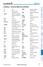
AVAILABLE DATABASES
This section will provide an overview of the databases available on the MFI. Databases
may vary depending on the unit configuration (Americas, Atlantic, or Pacific). See the System
Overview Section for information on updating databases.
Databases
Worldwide Basemap
Navigation Database (Garmin or Jeppesen
®
)
SafeTaxi
®
Obstacle
Terrain
Available Databases
Basemap
The Basemap database contains data for the topography and land features, such as river,
lakes, and towns. It is updated only periodically, with no set schedule. There is no expiration
date.
Navigation Database
The internal navigation database provides location and facility information for thousands of
airports, VORs, NDBs, and more. Updates to the navigation database are available every 28
days online (flygarmin.com). There are two navigation database products available: the Garmin
Navigation Database or the Jeppesen Navigation Database, which is sourced by Jeppesen.
NOTE:
Although the Jeppesen Navigation Database and the Garmin Navigation
Database contain much of the same information, pilots may notice differences in
behavior, nearest list functionality, direct-to functionality, and 'Map' Page display due
to data content variations.
NOTE:
After performing a navigation database update, cross check with any external
navigator which is providing flight plan data and verify all flight plan(s) (routes) are
current. If there is an obsolete aviation point in a saved route, the route is locked and
unusable. A new route with current navigation database points will need to be created.
SafeTaxi
The SafeTaxi database contains detailed airport diagrams for selected airports. These
diagrams aid in following ground control instructions by accurately displaying the aircraft
position on the map in relation to taxiways, ramps, runways, terminals, and services. This
database is updated on a 56-day cycle.
Summary of Contents for GI 275
Page 1: ...GI 275 Pilot s Guide ...
Page 2: ......
Page 4: ......
Page 12: ...Garmin GI 275 Pilot s Guide 190 02246 01 Rev A Warnings Cautions Notes Blank Page ...
Page 14: ...Garmin GI 275 Pilot s Guide 190 02246 01 Rev A Software License Agreement Blank Page ...
Page 16: ...Garmin GI 275 Pilot s Guide 190 02246 01 Rev A Record of Revisions Blank Page ...
Page 22: ...Garmin GI 275 Pilot s Guide 190 02246 01 Rev A vi Table of Contents Blank Page ...
Page 249: ......


