Garmin GI 275 Pilot's Guide
190-02246-01 Rev. A
140
Hazard Avoidance
System Overview
Flight Instruments
EIS
Navigation
Hazar
d A
voidance
Autopilot
Additional F
eatur
es
Appendices
Index
5.4 TERRAIN
WARNING:
Do not use Terrain information for primary terrain avoidance. Terrain
information is intended only to enhance situational awareness.
NOTE:
Terrain data is not displayed when the aircraft is outside of the installed terrain
database coverage area.
NOTE:
Terrain and obstacle alerting is not available north of 89º North latitude
and south of 89º South latitude. This is due to limitations present within the Terrain
database and the system’s ability to process the data representing the affected areas.
NOTE:
No terrain or obstacle alerting occurs if Terrain Proximity is the only terrain
function configured.
The following terrain configurations are allowed:
Terrain Function
Description
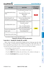
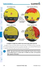
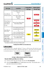
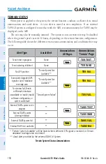
Terrain Proximity
Displays relative terrain and obstacle data.
Terrain-FLTA
Displays relative terrain and obstacle data and provides aural and visual
alerts for potential flight path conflicts involving terrain or obstacles
External TAWS-B
Interface
External TAWS-B system provides terrain data and alerts which can be
displayed on the MFI
Other external TAWS
See the pertinent flight manual for the external TAWS equipment
Terrain Configurations
The following is required for proper terrain display operation:
• Valid 3-D GPS position
• Valid terrain and obstacle databases
Summary of Contents for GI 275
Page 1: ...GI 275 Pilot s Guide ...
Page 2: ......
Page 4: ......
Page 12: ...Garmin GI 275 Pilot s Guide 190 02246 01 Rev A Warnings Cautions Notes Blank Page ...
Page 14: ...Garmin GI 275 Pilot s Guide 190 02246 01 Rev A Software License Agreement Blank Page ...
Page 16: ...Garmin GI 275 Pilot s Guide 190 02246 01 Rev A Record of Revisions Blank Page ...
Page 22: ...Garmin GI 275 Pilot s Guide 190 02246 01 Rev A vi Table of Contents Blank Page ...
Page 249: ......


