


Garmin GI 275 Pilot's Guide
190-02246-01 Rev. A
159
Hazard Avoidance
System Overview
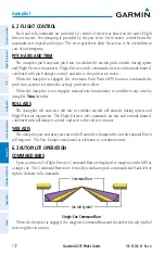
Flight Instruments
EIS
Navigation
Hazar
d A
voidance
Autopilot
Additional F
eatur
es
Appendices
Index
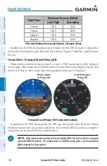
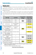
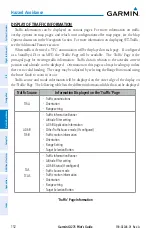
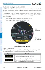
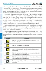
Traffic information for which TIS is unable to determine the bearing (non-bearing traffic) is
displayed in the center of the 'Traffic' Page or as a symbol at the bottom of maps other than the
'Traffic' Page on which traffic can be displayed.
The altitude difference between the requesting aircraft and other intruder aircraft is
displayed above/below the traffic symbol in hundreds of feet. If the other aircraft is above
the requesting aircraft, the altitude separation appears above the traffic symbol; if below, the
altitude separation appears below. Altitude trend is displayed as an up/down arrow (for speeds
greater than 500 fpm in either direction) to the right of the target symbol. Traffic symbols
for aircraft without altitude reporting capability appear without altitude separation or climb/
descent information.
tiS A
lertS
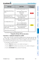
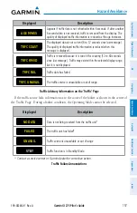
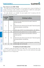
When the number of TAs on the 'Traffic' Page increases from one scan to the next, a
'TRAFFIC' annunciation will appear on the 'Traffic' Page, or as a pop-up alert.
To reduce the number of nuisance alerts due to proximate aircraft, the 'TRAFFIC' alert
annunciation is generated only when the number of TAs increases. For example, when the first
TA is displayed, an annunciation is generated. As long as a single TA remains on the display, no
additional alerts are generated. If a second TA appears on the display or if the number of TAs
initially decreases and then subsequently increases, another alert is generated.
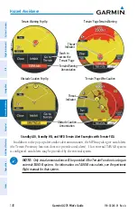
The annunciation 'UNAVAILABLE' is generated when the TIS service becomes unavailable
or is out of range. TIS may be unavailable in the radar coverage area due to the following:
Radar site TIS Mode S sensor is not operational or is out of service
Traffic or requesting aircraft is beyond the maximum range of the TIS-capable Mode
S radar site
Traffic or requesting aircraft is above the radar site in the cone of silence and out of
range of an adjacent site
Traffic or requesting aircraft is below radar coverage; in flat terrain, the coverage extends
from about 3000 feet upward at 55 miles; terrain and obstacles around the radar site
can further decrease radar coverage in all directions
Traffic does not have an operating transponder
tiS S
ySteM
S
tAtuS
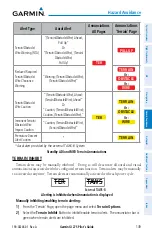
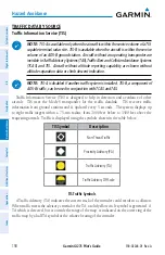
The system performs an automatic test of TIS when power is applied to the system. If TIS
passes the test, TIS enters Standby Mode (on the ground) or Operating Mode (in the air). If
TIS fails the test after power is applied to the system, an annunciation is shown in the center
of the 'Traffic' Page.
Summary of Contents for GI 275
Page 1: ...GI 275 Pilot s Guide ...
Page 2: ......
Page 4: ......
Page 12: ...Garmin GI 275 Pilot s Guide 190 02246 01 Rev A Warnings Cautions Notes Blank Page ...
Page 14: ...Garmin GI 275 Pilot s Guide 190 02246 01 Rev A Software License Agreement Blank Page ...
Page 16: ...Garmin GI 275 Pilot s Guide 190 02246 01 Rev A Record of Revisions Blank Page ...
Page 22: ...Garmin GI 275 Pilot s Guide 190 02246 01 Rev A vi Table of Contents Blank Page ...
Page 249: ......


