AeroNav 900/880 Series Pilot’s Guide
89000039-010
Rev 1 May 2019
SVS Subsystem
2-3
appear above that line, and conversely, terrain below the
aircraft’s altitude will appear below that line.
Placing the TVV/FPM above the terrain means that the airplane
will clear the terrain and vice versa. The terrain data and 9 arc-
second resolution used in creating the synthetic terrain depiction
is the same data and resolution used in the FLTA and TAWS
calculations for consistency.
The SynVis LSK (L2) is the toggle between the synthetic vision
image (“On”) and a traditional blue/brown Attitude Indicator (AI)
(“Off”) with a third state to turn the flight plan overlay on/off.
There are no autopilot mode display or control capabilities.
When there is an active flight plan, the active leg is displayed in
magenta and the next leg is depicted in alternating magenta and
white just as it is on the 2D map. No follow-on legs or waypoints
are depicted for declutter purposes. The depiction of the flight
plan can be turned on or off in the SynVis scene via the L2 LSK.
The next waypoint will have a waypoint identifier flag displayed.
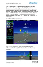
SynVis with Waypoint Flag
Summary of Contents for AeroNav 880
Page 4: ...AeroNav 900 880 Series Pilot s Guide 89000039 010 ii Rev 1 May 2019 Blank Page...
Page 94: ...AeroNav 900 880 Series Pilot s Guide 89000039 010 2 26 SVS Subsystem Rev 1 May 2019 Blank Page...
Page 292: ...AeroNav 900 880 Series Pilot s Guide 89000039 010 5 68 Aux Subsystem Rev 1 May 2019 Blank Page...
Page 315: ...AeroNav 900 880 Series Pilot s Guide 89000039 010 Rev 1 May 2019 Navigation 6 23...

