


17
When you plan a mission, have an idea of what conditions you will face at the launch point. Ideally, you should be
familiar with the launch area in order to avoid any unnecessary trouble with boat traffic, underwater obstructions,
inaccessible shoreline, etc. Always be sure to select an accessible and appropriate launch point in order to ensure a
successful mission. Once you have selected a launch site, locate it on the primary screen area. This is where you will
begin to plan a mission.
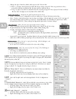
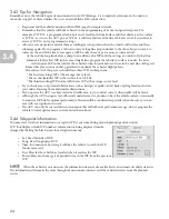
When you place a WP, decide how you want the vehicle to behave on each mission line. With the ‘Waypoints’ tab
selected in the control panel, you will be able to determine how the AUV will fly at any given point throughout its
mission. The vehicle proceeds according to the waypoint settings of the waypoint that it advances TOWARDS. As soon
as it passes a waypoint, it will alter its behavior to match the next waypoint and execute the line with those settings
(providing the vehicle’s settings change between waypoints.)
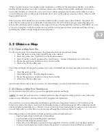
3.2 Obtain a Map
3.21 Open a Map from File
Use these instructions if you already possess the appropriate electronic georeferenced maps.
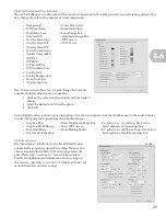
1. Click ‘File’ in the task bar in the top left corner of the window.
2. Hover the pointer over ‘New Mission’ in the dropdown menu
3. Select ‘From file’ in the fly-out menu. The ‘New Mission…’ window will prompt you to select a file.
4. Browse through your system files to locate the desired file.
5. Click on the file, then click open.
VectorMap will display the map in the primary screen area. Add additional concurrent map files to increase the survey
area.
1. Click ‘File’ in the task bar.
2. Click ‘Add Map File…’ from the dropdown menu.
3. Browse through your system files to locate the desired file.
4. Click on the file, then click open.
Add concurrent files as many times as necessary to obtain all maps you intend to include in the survey area.
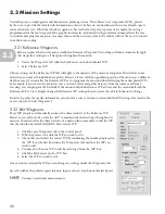
3.22 Obtain a Map from TerraServer
Use these instructions if you do not possess the appropriate georeferenced maps.
You must have internet access to obtain TerraServer maps through VectorMap. Also, be sure to allow the
program access through any existing internet safety programs when prompted.
Also note that you cannot permanently download any georeferenced map from TerraServer on VectorMap or the
TerraServer website. The map is used strictly for planning purposes to obtain navigational GPS coordinates and will
only be available with internet access. However, once you create and save a mission file, the map is not necessary and
you will still be able to use that file to run the mission, although the actual map will not be visible.
VectorMap provides several options to obtain a georeferenced area from TerraServer.
• Specified radius from United States postal address
• Specified radius from latitude/longitude coordinates
• Specific latitude/longitude bounds of area
• Entire data source bounds (used only to increase map after it is retrieved with one of the above methods)
• Current screen bounds (used only to increase map after it is retrieved with one of the above methods)
NOTE
3.2