™
Page 38 of 66
3 Using the vLoc3 RTK-Pro
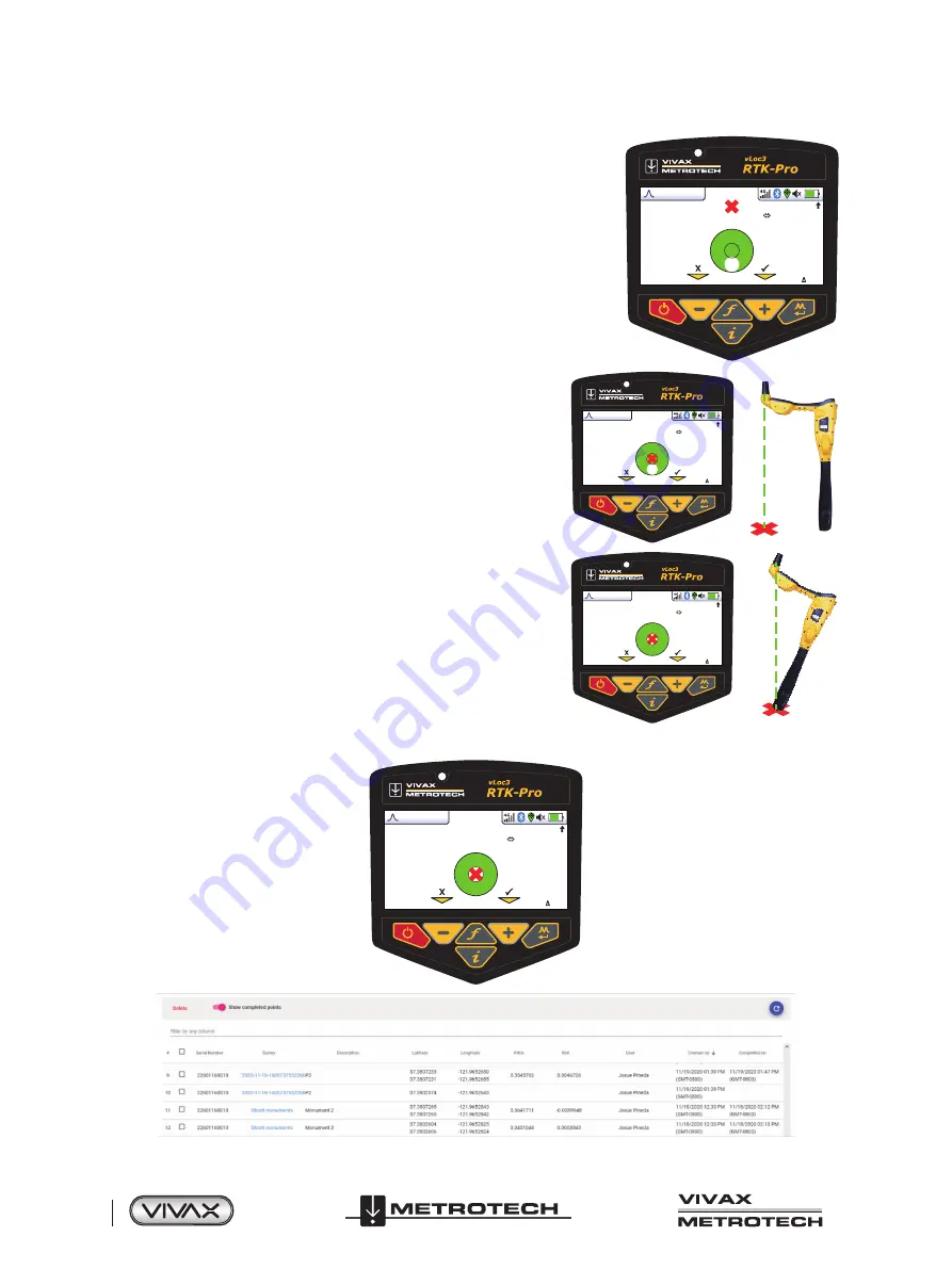
5. Follow the guidance arrow to get near the Walk Back point. Once within 10-feet
(3m), a crosshair icon will be displayed. A spirit level is shown. The center of the
spirit level represents the location of the GNSS antenna. You must maintain the
locator's orientation and move forwards and backward, left and right, and not
rotate the locator.
4G
0
50°57′32.1586′′N
3°52′29.1374′′W
564′2′′
0′1′′ (2DRMS)
9′5′′
6. As you walk toward the Walk Back point, you aim to get the red cross
in the center of the spirit level. Now the GNSS antenna is over the Walk
Back point.
4G
0
50°57′32.2514′′N
3°52′29.1374′′W
564′2′′
0′1′′ (2DRMS)
0′0′′
7. As you tilt the locator to get the GNSS antenna over the locator's foot,
you aim to get the spirit level bubble into the center of the spirit level.
When you have the locator's foot on the ground, and the Walk Back
point the red cross and the spirit level bubble will be in the center of the
spirit level, as shown in the illustration to the right.
4G
0
50°57′32.2514′′N
3°52′29.1374′′W
564′2′′
0′1′′ (2DRMS)
0′0′′
8. Use the + key to log the Walk Back as complete. This records how accurately the Walk Back was performed and marks the
Walk Back as complete in the VMMap Cloud.
4G
1
50°57′32.2514′′N
3°52′29.1374′′W
564′2′′
0′1′′ (2DRMS)
0′0′′
Содержание 4.04.000170
Страница 1: ...vLoc3 RTK Pro User Handbook English Edition Version 1 1 P N 4 04 000170...
Страница 2: ......
Страница 8: ......
Страница 76: ......


