Our Experience
33
Things to watch out for when mapping with a smartphone
1.
Make sure that you
lock
your iPhone
when it is
in your pocket
. This will ensure that
you don’t end up with ‘ghost’ readings while you’re en route to the next outcrop.
2. Check that the
GPS location has updated
to your current location,
before saving
a
reading. Look at the time stamp (underneath the lat / long values) and check that this
has the lat / long values for your current location. If you are still unsure if the GPS has
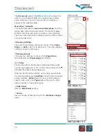
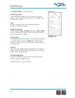
placed you correctly, tap the lat / long reading (this will bring up the Map page) where
you can check that your current location is correct on the map.
3. Make sure that your iPhone has
enough storage space
for a day’s data collection. We
recommend that, at the end of each day, you copy your files from your phone to your PC
and back these up. You can then delete the project from your phone and start a new
project, to free up memory. To put a project back onto your iPhone, simply paste it from
its saved location on your PC into the app folder through iTunes.
4. At the start of the day,
check
your phone’s
calibration
before taking a reading. Make
sure that you are away from buildings, cables, vehicles and jewellery and compare the
readings from your iPhone with a traditional compass-clinometer.
5. Take care to check that you have made the
right lithology and structure type
choices
before hitting the
Save
button. It is very easy to collect incorrectly classified data, which
cannot be used later (e.g. you have recorded a cleavage measurement as bedding or
vice-versa).
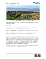
Note on the geology of Ardmore Point
All the screen shots and photos in this guide are taken from Ardmore Point which is
approximately 30km north-west of Glasgow. The strata exposed on the shore are Devonian
in age, with excellent antiform and synform structures, faults and fractures with exposures
of the Lower and Upper Old Red Sandstone. We frequently run training course at this
location and other sites. Please get in touch if you would like to join us to learn more about
digital field mapping from the experts.
Closing remarks
We find that digital mapping tools improve the 3D spatial interpretation process by
facilitating more analysis and less data management than traditional techniques, especially
in the “field office” during the evenings. With a digital mapping workflow, data organisation
largely occurs in the field upon data collection, transcription from paper to digital format is
unnecessary, and data backup can be as simple as copying digital files to external hard
drives. Digital mapping allows more time in the evenings for problem solving, targeting
areas of uncertainty, and formulating effective field plans.
Содержание FieldMove Clino
Страница 1: ......

