background image

Compass / Clino   


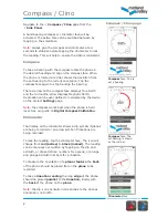
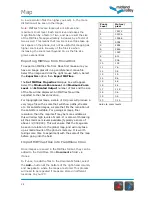
Compass

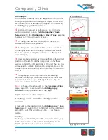
 face. The 

set bearing is shown 
by the red bar.   


Clinometer

 face


Compass

 face. Tap to 

set a bearing

.  


Compass / Clino page     


Navigate to the   

Compass / Clino

 page from the        


Side Panel

.  


A hand bearing compass or clinometer face will be 
activated. The active face can be switched between by 
tapping on the small face. 

Note: 

always give the compass and clinometer a few 

seconds to stabilize before tapping the clinometer to lock 
the reading. This will help to ensure the data is consistent. 

Compass


To take a bearing with the compass rotate the phone in 
the desired heading and tap on the compass face. When 
the phone is rotated a red bar shows the deviation from 
the set bearing to the current orientation. Tap the 
compass face again to stop tracking the bearing. 

The red arrow on the compass face displays True North 
and the red outline arrow displays Magnetic North. 
Declination can be user defined or calculated by the device 
on the project 

Settings


page.  

Note:

 the compass works best when the phone is held 

level. See our guide on 

Digital Compass Calibration

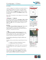
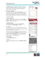
Clinometer


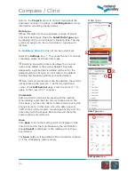
The display on the clinometer shows a dip symbol if planes 
are being recorded or an arrow symbol if lineations are 
being recorded. 
 
To lock the reading, tap the clinometer face. The icon will 
change from 

red (active)

 to 

black (locked)

. The reading 

can be manually overwritten by tapping on the dip and 
azimuth, or dip and strike numbers for a plane; or plunge 
and plunge azimuth numbers for a lineation.  


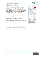
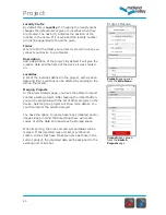
To measure the orientation of a 

planar feature

 the 

back


of the phone should be placed flat on the 

plane

 to be 

recorded. 

To take a 

lineation reading

 the long 

edge

 of the phone 

should be placed 

parallel

 to the 

lineation, 

ideally with 

the 

back

 of the phone on the 

plane

Note: 

the dip icon orientation corresponds to the phones 

orientation, not north. 


Содержание FieldMove Clino

Страница 1: ......

Страница 2: ...ap Stereonet 19 View structural data on an equal area or equal angle stereonet FieldMove Clino Pro only Project 20 Details of the active project Switch Project 22 Switching between active projects and...

Страница 3: ...are an integral part of this new technology allowing the capture and storage of georeferenced photographs and text notes FieldMove Clino Pro allows stereonets to be plotted lines and polygons to be d...

Страница 4: ...aw your attention to the advice given by a number of mountaineering councils Everyone heading into the hills needs to learn how to read a map and be able to navigate effectively with a paper map and t...

Страница 5: ...s or line objects i e to define a rock type or a fault This information is recorded as an attribute on the object Data Type Defined as planar and linear data Location can be set automatically using th...

Страница 6: ...ch can be edited and deleted Map Displays structural data on online and offline maps and in FieldMove Clino Pro allows line drawing Stereonet Available in FieldMove Clino Pro the stereonet displays da...

Страница 7: ...ays True North and the red outline arrow displays Magnetic North Declination can be user defined or calculated by the device on the project Settings page Note the compass works best when the phone is...

Страница 8: ...the last time a new position was found Idle The black arrow with a white background indicates that the phone s GPS is idle Any new data point or note will be assigned to the last location update the a...

Страница 9: ...p to set a new position This will automatically set the GPS to idle Alternatively lat long values can be entered in Degrees Minutes Seconds using the number key pad If you tap the GPS arrow the GPS wi...

Страница 10: ...he correct position in the list To do this long press on the three vertical dots on the left hand side of the unit The unit row will expand to indicate it can now be dragged Move it to the desired loc...

Страница 11: ...ill be set to the default symbol of its type For this reason the default bedding and lineation symbols cannot be deleted New icons icon and name can be added to the current list by pressing the plus i...

Страница 12: ...r the rock unit data type comment and location can be edited The rock unit and comments can be edited in the same way as on the Compass Clino page When editing the data type the data cannot be convert...

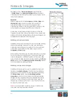
Страница 13: ...ing the bin icon will also delete the entry Filters allow the Notes Images page to be filtered to display All data or just Notes Datum or Lines They can be accessed by scrolling to the top of the list...

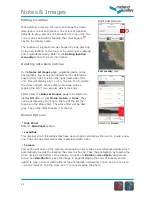
Страница 14: ...iptions which would normally feature in a field notebook An image can be attached to the note by tapping the camera icon The image can be selected from the camera roll or a new photo can be taken Tap...

Страница 15: ...e Maps Choose which map is used as the base map from the drop down menu Refer to Importing Map section for more information Drawing FieldMove Clino Pro allows lines and polygons to be drawn on the map...

Страница 16: ...line white and polygon black drawing Lines can be extended or joined together To extend an existing line tap on it to selected it it will be highlighted in yellow Start drawing from the end of the ex...

Страница 17: ...d in the map as you move around your mapping area Tapping again the map will spin to show facing direction This means the map will be rotated to match your orientation Tapping the compass again will s...

Страница 18: ...ps All the maps that are added to the FieldMove Clino Documents folder via iTunes will be listed here as New Maps Tap on the icon to add the selected map to the current Project Map List Tap on the ico...

Страница 19: ...topographical maps a scale of 1m pixel will produce a very large file with a scale that will show paths streams etc For satellite images a scale that fits the resolution of the satellite is suitable...

Страница 20: ...three display settings to choose from Poles Plane or Both Tap one to activate it The active display setting is shown as dark grey Stereonet plot There are two settings to choose from Equal Area Schmi...

Страница 21: ...A list of the localities defined in the project with creation date and time Localities can be deleted by swiping to the left on the locality Merging Projects In the project details page you have the...

Страница 22: ...a locality in the Project Details page Note that the active locality cannot be deleted Change the active locality from the Compass Clino or Notes Images pages Delete Project This will permanently remo...

Страница 23: ...the iPhone follow the steps below First find the fm folder saved onto your computer and use Zip to create an archive as iTunes does not handle moving folders directly to an iPhone Once zipped bring th...

Страница 24: ...ct the information icon for the project you wish to delete This will display the project details Scroll to the bottom and select Delete Project This will remove the project from the device Note you ca...

Страница 25: ...the right hand rule RHR Both conventions are used when the project is exported Line Picking In FieldMove Clino Pro define the sensitivity that should be used to select a line in the Map page With a la...

Страница 26: ...rst time you will be asked to grant permission so that FieldMove Clino can access your Dropbox This will be done from the Dropbox app if it s installed or otherwise via a web interface You can then br...

Страница 27: ...ic location of each photo is found in the image CSV file along with the name of the image file All images can be found in the images folder which is stored in the project folder on the iPhone Note CSV...

Страница 28: ...ion algorithms There are also differences between the mobile operating systems and how they allow developers to access and manipulate the sensors available on each device We are reluctant to recommend...

Страница 29: ...good data being recorded irrespective of the orientation of the phone These questions may help you Does the phone have reasonable consistency with itself in all orientations and situations Does the ph...

Страница 30: ...ading using the Compass Clino Planar or linear readings are taken from the Compass Clino page If required activate the clinometer by tapping on the small clinometer to the right of the compass face At...

Страница 31: ...cality in the list to open the Edit Locality page The name of future localities can be set by changing the Locality Prefix in the Project Details page accessed from the Side Panel Refer to the Notes I...

Страница 32: ...box If you disable online connectivity the map view will still work but will only show a basic grid in places where there is no cached data Please note that activating airplane mode will also turn off...

Страница 33: ...oof Idry Aquapac etc Preparation A common hindrance to successful digital geologic mapping is a lack of advance preparation before leaving for the field In addition to collation of digital base maps e...

Страница 34: ...hone with a traditional compass clinometer 5 Take care to check that you have made the right lithology and structure type choices before hitting the Save button It is very easy to collect incorrectly...

Страница 35: ...able to download from the Google Play Store Please note that the Android app is for smartphones only and will not scale up to 7 or 10 tablet devices Minimum Android model requirements A smartphone run...

Страница 36: ...Move Move provides workflows for digital field mapping cross section construction 3D model building kinematic restoration and validation geomechanical modelling fracture modelling stress analysis and...

Отзывы: