7-1
Section 7 Specifications
5
6
Section 7 Specifications
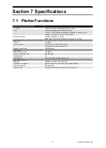
7.1 Plotter Functions
FUNCTIONAL SPECIFICATIONS
Projection
Mercator projection (Latitude 85 degree or less)
Scale
Synchronise range scale (Synthesis mode)
1/1,000 ~ 1/30,000,000 are continuously selected. 15 stage can be
changed (preset can be used). (Plotter mode)
Position correction
Latitude / Longitude correction
Radar video synchronise range scale coast line by manual.
Own track
Colours
10 colours
Interval of save
3/5/10/30 sec, 1/3/5/10/30/60 min, or
0.1/0.2/0.3/0.5/1/3/5/10 NM and Off.
Capacity of own track
1000,000 point
User Map
Colours (Mark / Line)
10 colours
Capacity of mark and line
200,000 point
Variety of mark
29
Variety of line
Solid line, Dotted line, and Broken line
Waypoint and route
Waypoint
Waypoint can be set up to 999 point.
Information of waypoint
Azimuth, distance and the time to required destination.
Setting of sea route
999 sea routes.
Alarm of route
Waypoint arrival / break off, Route arrival / break off.
Содержание JMR-5400 Series
Страница 2: ......
Страница 58: ...Section 2 Basic Operations and Mode Screen 2 32 ...
Страница 86: ...Section 4 Route Planning 4 18 ...
Страница 96: ...Section 5 Route monitoring 5 10 ...
Страница 124: ...Section 7 Specifications 7 2 ...
Страница 205: ......


