


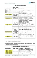


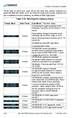


Section 2 System Overview
1
st
Ed Nov 2018
IDU-450 EFIS Software Version 8.0H (Rotorcraft)
2-45
6) Once both databases have been uploaded, power down the IDU,
remove the USB flash drive, and lower the USB door.
7) Once each IDU has been updated, power up the entire EFIS in normal
flight mode and verify each IDU successfully updated with the latest
database by noting the new navigation database and obstruction
database cycle expiration dates before acknowledging the initialization
screen (Figure 2-4). Because the obstruction database is advisory in
nature, there technically is no expiration date. The listed date is the
effective date of the next available obstruction database.
8) A cyclic redundancy check (CRC) self-test verifies the data at every
step of the process, thereby ensuring the data installed into the system
has not been corrupted at any point during the process.
2.6.3 Software and Terrain Database Update
Updates and terrain database updates are provided on an as-needed basis
and performed as per a service bulletin.
2.7
Run Demonstrator /Training Program
The EFIS has a built-in demonstration application to fly anywhere in the
world while performing any procedure (except takeoff and landing) based
on the current navigation database. Use this feature on the ground in
ground mode as follows:
1) With power off, lift the USB flash drive door.
2) Power on the system. Scroll
to
RUN DEMONSTRATOR/ TRAINING
PROGRAM
and push to enter.
Use the demonstrator to gain familiarity of the EFIS menu structure and
location of button tiles for each operation. Load an instrument procedure
prior to take off to view the expected sequence of events.
The demonstrator begins flying over Reno, Nevada, USA at an altitude of
approximately 8000’ MSL. Altitude may be changed with altitude bug,
VNAV profiles or navigation database procedures. Airspeed remains
relatively constant but may be controlled with the airspeed IAS bug in the
BUGS menu. The simulated aircraft may be positioned anywhere in the
world, by activating a flight plan stored in the memory.
All appropriate navigation signals are simulated, allowing for precision and
non-precision instrument approaches found within the current navigation
database. All obstructions in the latest obstruction database and all time-
critical warning, caution, and advisory audible and flag annunciations are
presented as appropriate during simulated flights.


