

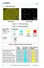


Traffic
T-6
IDU-450 EFIS Software Version 8.0H (Rotorcraft)
1
st
Ed Nov 2018
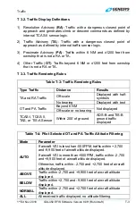
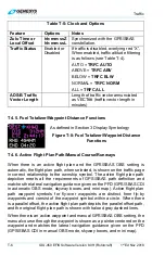
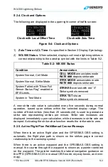
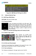
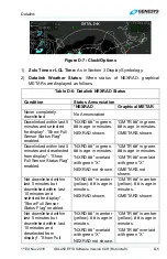
Table T-5: Clock and Options
Feature Options
Notes
Zulu Time or
Local Offset
hh:mm:ssZ
hh:mm:ssL
Synchronized with the GPS/SBAS
constellation.
Traffic Status
Enabled or
Disabled
If traffic is disabled, overlying red “X”.
When enabled, traffic altitude filtering
is as follows (see Table T-4).
AUTO =
TRFC AUTO
ABOVE =
TRFC ABV
BELOW =
TRFC BLW
NORMAL =
TRFC NORM
ALL =
TRFC ALL
ADS-B Traffic
Vector Length
Length of traffic vector annunciated
as VECT## (traffic vector length in
minutes)
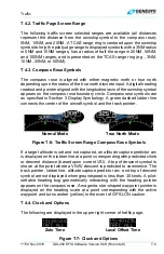
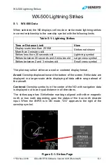
T 4.5. Fuel Totalizer/Waypoint Distance Functions
As defined in Section 3 Display Symbology
Figure T-8: Fuel Totalizer/Waypoint Distance
Functions
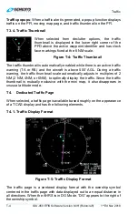
T 4.6. Active Flight Plan Path/Manual Course/Runways
When there is an active flight plan and the GPS/SBAS OBS setting is
automatic, the flight plan path, when selected, is shown on the traffic page
in correct relationship to the ownship symbol. The active flight plan path
depiction meets all the requirements of GPS/SBAS path definition and
matches the lateral navigation guidance given on the PFD (GPS/SBAS CDI
in automatic OBS mode, skyway boxes, and mini map). Active flight plan
path waypoint symbols for fly-over waypoints are distinct from fly-by
waypoints and consist of the waypoint symbol within a circle. When there
is a parallel offset, the active flight plan path depicts the parallel offset path,
and the original flight plan path is shown with haloed gray dashed lines.
When there is an active waypoint and manual GPS/SBAS OBS setting, the
manual course through the waypoint is shown as a pointer centered on the
waypoint and matches the lateral navigation guidance given on the PFD
(GPS/SBAS CDI in manual OBS mode, skyway boxes, and mini map).


