Garmin GI 275 Pilot's Guide
190-02246-01 Rev. A
13
System Overview
System Overview
Flight Instruments
EIS
Navigation
Hazar
d A
voidance
Autopilot
Additional F
eatur
es
Appendices
Index
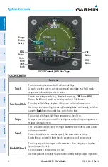
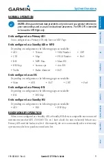
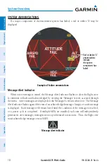
During system initialization, the AHRS displays the message ‘AHRS ALIGN, KEEP WINGS
LEVEL’ over the attitude indicator. If a heading indicator is configured, a red 'X' will be
displayed until the instrument receives valid heading data. The AHRS should display valid
attitude and heading fields typically within the first minute of power application.
The AHRS can align itself both during flight and while taxiing. The realign can occur
provided the MFI is restarted while in straight and level flight or while taxiing in straight and
level conditions (+/- 5 ° pitch, +/- 10° roll). When realigning, the ADI’s attitude information
is removed and replaced with an annunciation instructing the pilot to attempt to maintain
straight and level flight. Depending on the conditions, airborne and taxiing alignments are
usually successful within 1-2 minutes.
Heading indications are corrected for shifts and variations in the Earth’s magnetic field
by applying the Magnetic Field Variation Database. The Magnetic Field Variation Database
is derived from the International Geomagnetic Reference Field (IGRF). The IGRF is a
mathematical model that describes the Earth’s main magnetic field and its annual rate of
change. The database is updated approximately every 5 years through a Navigation database
update. Failure to update this database could lead to erroneous heading information being
displayed to the crew.
Any failure of the AHRS sensors results in loss of attitude and heading information and
failure of ADC sensors results in loss of air data information (indicated by red ‘X’ flags over
the corresponding flight instruments). If the MFI senses the magnetic heading measurement
is valid, but possibly outside of the internal accuracy limits, the numeric heading value will be
displayed in amber.
If the magnetometer input fails, the heading output is flagged as invalid with a red 'X' but
track information is displayed instead if valid GPS data are available.
In installations that include multiple air data and AHRS units (MFI supports up to two
external air data and AHRS sources in addition to the internal ADAHRS source if equipped), if
data from an air data or AHRS source is lost, the MFI can display data from alternate sources.
A data failure condition is annunciated by 'X's over instruments, miscompare flags, or no
compare flags. Data source switching is not automatic. Reversionary sensor selection is
annunciated near the relevant data field or at the top of the display.
Manually switching AHRS or ADC sensors:
1)
From the 'ADI' Page, open the menu.
2)
Select the
ADI Options
or
Options
Button.
3)
Select the
Sensors
Button.
4)
Select the
AHRS
or
ADC
Button, then the desired AHRS or ADC source.
Содержание GI 275
Страница 1: ...GI 275 Pilot s Guide ...
Страница 2: ......
Страница 4: ......
Страница 12: ...Garmin GI 275 Pilot s Guide 190 02246 01 Rev A Warnings Cautions Notes Blank Page ...
Страница 14: ...Garmin GI 275 Pilot s Guide 190 02246 01 Rev A Software License Agreement Blank Page ...
Страница 16: ...Garmin GI 275 Pilot s Guide 190 02246 01 Rev A Record of Revisions Blank Page ...
Страница 22: ...Garmin GI 275 Pilot s Guide 190 02246 01 Rev A vi Table of Contents Blank Page ...
Страница 249: ......


