


Garmin GI 275 Pilot's Guide
190-02246-01 Rev. A
125
Hazard Avoidance
System Overview
Flight Instruments
EIS
Navigation
Hazar
d A
voidance
Autopilot
Additional F
eatur
es
Appendices
Index
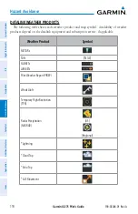
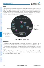
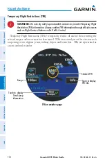
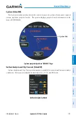
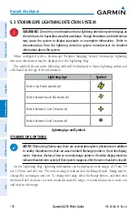
NEXRAD
NEXRAD (NEXt-generation RADar) is a network of multiple high-resolution Doppler
radar sites that are operated by the National Weather Service (NWS). NEXRAD data provides
centralized meteorological information for the continental United States and selected overseas
locations. The maximum range of a single NEXRAD radar site is 250 nm. In addition to a wide
array of services, the NEXRAD network provides important information about severe weather
and air traffic safety. NEXRAD data is not real-time. The lapsed time between collection,
processing, and dissemination of NEXRAD images can be significant and may not reflect the
current radar synopsis.
Composite NEXRAD data is composed of the maximum reflectivity from the individual
radar sweeps. The display of the information is color-coded to indicate the weather severity
level.
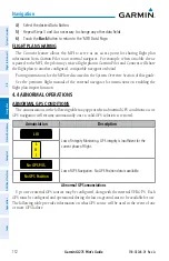
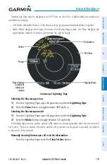
The display of radar coverage is always active when NEXRAD is selected. Areas where
NEXRAD radar coverage is not currently available or is not being collected will be depicted as
'No Radar Coverage' until coverage is restored.
There are possible abnormalities regarding displayed NEXRAD images. Some, but not all,
of those include:
»
Ground clutter
»
Strobes and spurious radar data
»
Sun strobes (when the radar antenna points directly at the sun)
»
Military aircraft deploy metallic dust (chaff) which can cause alterations in radar scans
»
Interference from buildings or mountains, which may cause shadows
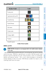
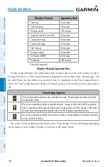
Certain limitations exist regarding the NEXRAD radar displays. Some, but not all, are listed
for the pilot’s awareness:
»
NEXRAD base reflectivity does not provide sufficient information to determine cloud
layers or precipitation characteristics (hail vs. rain). For example, it is not possible to
distinguish between wet snow, wet hail, and rain.
»
NEXRAD base reflectivity is sampled at the minimum antenna elevation angle. An
individual NEXRAD site cannot depict high altitude storms at close ranges and has no
information about storms directly over the site.
»
Radar coverage only extends to 55°N.
Содержание GI 275
Страница 1: ...GI 275 Pilot s Guide ...
Страница 2: ......
Страница 4: ......
Страница 12: ...Garmin GI 275 Pilot s Guide 190 02246 01 Rev A Warnings Cautions Notes Blank Page ...
Страница 14: ...Garmin GI 275 Pilot s Guide 190 02246 01 Rev A Software License Agreement Blank Page ...
Страница 16: ...Garmin GI 275 Pilot s Guide 190 02246 01 Rev A Record of Revisions Blank Page ...
Страница 22: ...Garmin GI 275 Pilot s Guide 190 02246 01 Rev A vi Table of Contents Blank Page ...
Страница 249: ......


