
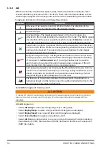


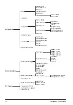


5.4
Menu Tree
65
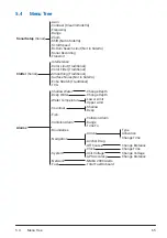
5.4 Menu Tree
Sonar Setup
(Sonar)
- Gain
- Contrast (ClearVü/SideVü)
- Frequency
- Range
- Zoom
- Shift (Not in SideVü)
- Scroll Speed
- Bottom Search Limit (Not in SideVü)
- Sonar Recording
- Transmit
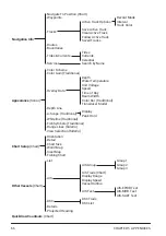
Clutter
(Sonar)
- Interference
- Color Limit (Traditional)
- Color Filter (Traditional)
- Smoothing (Traditional)
- Surface Noise (Not in SideVü)
- Echo Stretch (Traditional)
- TVG
Alarms
- Shallow Water
- Change Depth
- Deep Water
- Change Depth
- Water Temperature
- Lower Limit
- Upper Limit
- Countour
- Shallow
- Deep
- Fish
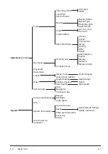
- Collision Alarm
- Collision Alarm
- Range
- Time To
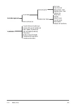
- Boundaries
- Arrival
- Type
- Navigation
- Activation
- Change Time
- Anchor Drag
- Off Course
- Change Distance
- System
- Clock
- Change Time
- Unit Voltage
- Change Voltage
- GPS Accuracy
- Change Distance
- Network
- NMEA 2000 Alerts
- Fuel
- Total Fuel Onboard
Содержание CS 1522
Страница 1: ...CS 1522 Professional Fishfinder Owner s Manual...
Страница 44: ...CHAPTER 2 GETTING STARTED 42...
Страница 72: ...CHAPTER 5 APPENDICES 70...
Страница 73: ......