background image


15

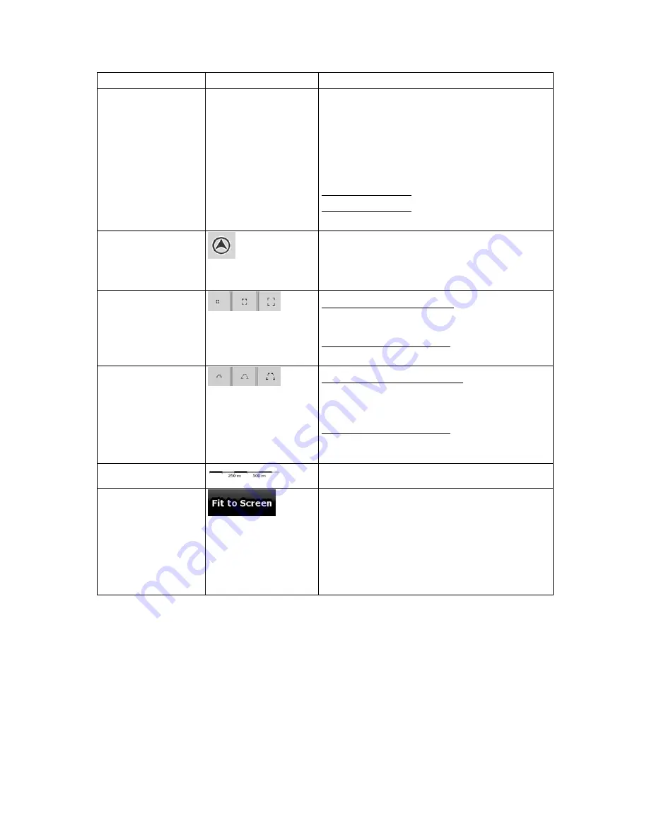
Action 

Button(s) 

Description 


When you are approaching a turn, AZ291MA 
zooms in and raises the view angle to let you 
easily recognize your maneuver at the next 
junction. 


If the next turn is at a distance, AZ291MA 
zooms out and lowers the view angle to 
show you the road in front of you. 

Tap this button once to enable Smart Zoom. 
Tap&hold the button to set the zoom limits of Smart 
Zoom. 

Returning to normal 
navigation (back to the 
GPS position with 
automatic map 
rotation) 


Tap this button to move the map back to the current 
GPS position. If the map has been rotated, 
automatic map rotation is also re-enabled. 

Zoom preset buttons 
(available in Advanced 
mode only) 


Tap one of the preset buttons to set the zoom level 
to a fix, predefined value. Smart Zoom is disabled.
These buttons are available in 2D mode. 
Tap&hold any of the buttons to set its value to the 
current zoom level, or to reset it to its original value.

Tilt and zoom preset 
buttons (available in 
Advanced mode only) 


Tap one of the preset buttons to set the tilt and 
zoom levels to fix, predefined values. Smart Zoom
is disabled. These buttons are available in 3D 
mode. 
Tap&hold any of the buttons to set its value to the 
current tilt and zoom levels, or to reset it to its 
original value. 

Map scale 


AZ291MA shows the scale of the map in 2D mode. 

Fit-to-screen 


This button does not appear on the Map screen. It 
is available on the following screens: 


Plan on Map screen: When you have an 
active route, you can display it in its full 
length on the map. 


Track Information screen: A track log can be 
displayed in its full length on the map. 


Содержание AZ291MA

Страница 1: ...User Manual AZ291MA Navigation software for PND US English June 2009 ver 1 1 ...

Страница 2: ...otification This manual may not in whole or in part be reproduced or transmitted in any form either electronically or mechanically including photocopying and recording without the express written consent of Aviton Care Limited 2009 Aviton Care Limited Data Source 2009 Tele Atlas N V All rights reserved ...

Страница 3: ...t Guide first and start using the PND right away This document is the detailed description of the navigation software You can easily discover the PND while you are using it however we still recommend that you read this manual to understand the screens and the features of AZ291MA ...

Страница 4: ...iginal position in the Cursor menu 22 2 4 3 Daytime and night color profiles 22 2 4 4 Color scheme in tunnels 23 2 4 5 Route calculation and recalculation 23 2 4 6 Itinerary 24 2 4 7 Track Logs 25 2 4 8 Route demonstration 25 2 4 9 POI Points of Interest 25 2 4 10 Road Safety Cameras 26 2 4 10 1 Camera types 27 2 4 10 2 Camera directions 28 2 4 11 Speed limit warning 28 2 4 12 TMC Traffic Message ...

Страница 5: ... 43 3 8 Pausing the active route 44 3 9 Deleting the next via point from the route 44 3 10 Deleting the active route 44 3 11 Using Track Logs 44 3 12 Saving the active route 46 3 13 Loading a saved route 46 4 Reference Guide Advanced mode 47 4 1 Map screen 47 4 1 1 Icons on the map 50 4 1 1 1 Battery GPS position quality and Vehicle type indicator 50 4 1 1 2 Status indicator strip 51 4 1 1 3 Next ...

Страница 6: ...er Data Management 69 4 5 Settings menu 70 4 5 1 Map Screen settings 71 4 5 2 Sound settings 72 4 5 3 Route Planning options 72 4 5 4 Regional settings 74 4 5 5 Navigation settings 75 4 5 6 Warning settings 76 4 5 7 GPS settings 77 4 5 8 TMC settings 77 4 5 9 Menu settings 78 4 5 10 Device settings 79 4 5 11 Track Log settings 79 5 Glossary 80 6 End User License Agreement 82 ...

Страница 7: ...ange something in the route AZ291MA has a Safety Mode if you turn on Safety Mode you cannot change anything in AZ291MA while the vehicle is moving at a speed of 10 km h 6 mph or higher Unless only passengers operate AZ291MA we strongly encourage you to turn on Safety Mode You must obey the traffic signs and follow the road geometry If you deviate from the route that AZ291MA recommended AZ291MA cha...

Страница 8: ...nd maximum zoom level of Smart Zoom Tap and hold any of the buttons on the Map screen you can set or reset the zoom value of the button 2D map Tap and hold any of the buttons on the Map screen you can set or reset the tilt and zoom values of the button 3D map Tap and hold on list and menu screens the Navigation menu appears Tap and hold any of the and buttons on the Map screen you can rotate tilt ...

Страница 9: ...n the two operating modes in Settings After this the Navigation menu appears and you can start using AZ291MA The Navigation menu in Simple mode The Navigation menu in Advanced mode The typical way of using AZ291MA is to select a destination and start navigating You can select your destination in the following ways not all of them are available in Simple mode Use the selected location on the map th...

Страница 10: ...ting to a street address Yes Yes See page 31 Navigating to an incomplete address Yes Yes See page 31 Navigating to an intersection Yes Yes See page 35 Navigating to recent destinations History Yes Yes See page 40 Navigating to Favorites Yes Yes See page 38 Navigating to a POI Yes Yes See page 38 Navigating to coordinates No Yes See page 40 Creating a multi point route No Yes See page 41 Saving a m...

Страница 11: ...eter Tap it once Icon Shows status information Some icons also function as a button Tap them once List When you need to select from several options they appear in a list Move between pages with the and buttons and tap the value that you want Slider When a feature has several different unnamed values AZ291MA shows an indicator on a gauge that displays and sets a value from a range Drag the handle t...

Страница 12: ...e next time you need to enter data Correcting your entry on the keyboard Tap to remove the unneeded character s Tap and hold the button to delete the entire input string Entering a space for example between a first name and a family name or in multi word street names Tap Entering lowercase or capital letters Tap to cycle through entering lowercase letters initial capitals or all capitals Entering ...

Страница 13: ...of nearby POIs will be displayed It is even easier if you select the desired point in the Find menu Then the Cursor menu opens automatically You only need to tap the button 2 3 2 Manipulating the map Position markers on the map Current GPS position page 21 Selected location Cursor page 22 The following controls help you modify the map view to suit your actual needs the best Most of these controls ...

Страница 14: ... right Changes the horizontal view angle of the map in 3D mode When GPS position is available AZ291MA always rotates the map so its top faces your direction of travel Track Up orientation You can turn away from Track Up with these buttons If GPS position is available and you have rotated the map the button appears Tap this button to re enable the automatic map rotation Viewing modes Gives you the ...

Страница 15: ... to set the zoom level to a fix predefined value Smart Zoom is disabled These buttons are available in 2D mode Tap hold any of the buttons to set its value to the current zoom level or to reset it to its original value Tilt and zoom preset buttons available in Advanced mode only Tap one of the preset buttons to set the tilt and zoom levels to fix predefined values Smart Zoom is disabled These butt...

Страница 16: ...others are darkened out 2 3 4 Status information and hidden controls on the map The following information appears in the rounded field in the top left corner the Turn Preview field When tapping this area the result depends on the information currently shown Icon Information Details Action There is no active route in Simple mode If there is no route to be navigated in Simple mode this icon appears ...

Страница 17: ...here is no route to be navigated the traffic restriction of the upcoming intersection is shown here if there is any Nothing happens if you tap this area of the screen Second route event maneuver after the next maneuver When GPS position and an active route are both available this field shows the route event that follows the next route event shown in the above described area Tap this area to open t...

Страница 18: ... Traffic events but it has not been bypassed for example even the best detour would be too long or it could not be bypassed for example the destination is on a congested street The following information can be seen in the three data fields shown on the map screen Tap this area to open the Trip Information screen where you can select which values to be shown in these three fields When there is no a...

Страница 19: ...ry is being charged The device is running on external power The battery is being charged Vehicle type The symbol displays the vehicle type used for route calculation 2 3 5 Using the Cursor the selected map location First place the Cursor at the desired map location with one of the following options Use the Find menu to select a location The map returns with the selected point the Cursor in the mid...

Страница 20: ...able in Advanced mode only Saves the Cursor as a Road Safety Camera location available in Advanced mode only This button is not displayed when GPS position is not available or if you are in certain countries where Road Safety Camera warning is prohibited Even if the button is available you are responsible for checking whether it is legal to use this feature at your location 2 4 AZ291MA concepts 2 ...

Страница 21: ...ay not show your exact GPS position and heading If roads are near it is aligned to the nearest road to suppress GPS position errors and the direction of the icon is aligned to the direction of the road To use the current GPS position tap The Position menu appears and you can save the GPS position as one of the following a Favorite a Road Safety Camera a POI a map marker Pin 2 4 2 2 Returning to no...

Страница 22: ... icon shows the Cursor position the menu was opened with You can move and zoom the map and you can set the Cursor to a different place The usual Cursor appears and the buttons of the Cursor menu initiate actions for this new location To return to the original Cursor position tap The map jumps back to the position with which the Cursor menu was opened and the icon appears again 2 4 3 Daytime and ni...

Страница 23: ...n AZ291MA calculates the route based on your preferences Route calculation method Fast Short Economical Easy Vehicle types Car Taxi Bus Emergency vehicles Bicycle Pedestrian Road types Unpaved Roads Permit Needed Freeways Toll Roads Charge Roads Ferries Cross border Planning Carpool appears only when used in the USA AZ291MA automatically recalculates the route if you deviate from the proposed itin...

Страница 24: ...Any of the list items Opens the map with the selected maneuver in the middle Changes the detail level of the Itinerary The levels are as follows Detailed Instructions all intersections are listed Itinerary only significant intersections the ones announced in voice guidance are listed Road list the list of the roads used while navigating the route Moves between pages for additional list items When ...

Страница 25: ...t normal driving speed You can use it for example to see which bridge AZ291MA planned for the route if you do not want to take that bridge you can avoid it Route demonstrations can be started from the Route menu by tapping the high speed simulation or the simulation at normal speed button 2 4 9 POI Points of Interest A point of interest POI is a location that someone might find useful or interesti...

Страница 26: ...a special POI These cannot be searched like other POIs and there is a special proximity warning only for cameras Is PND shipped with a built in database of Road Safety Cameras No Can Road Safety Camera locations be uploaded in a text file Yes Can you save the Cursor as the location of a Road Safety Camera Yes Saving Road Safety Cameras To save the location of a Road Safety Camera place the Cursor ...

Страница 27: ...r speed exceeds the speed limit near the speed camera AZ291MA plays a special warning sound Mobile Some speed cameras are operated from vehicles They do not always work and they are not set to check a preset speed limit The warning is similar to fixed speed cameras but as there is no speed limit given only the proximity is announced Built in Some speed cameras are built into traffic lights They wo...

Страница 28: ...asured or possibly measured direction The measured direction of the camera appears with the following symbols Icon Description The camera checks speed in the direction into which you are driving The camera checks speed in the opposite driving direction The camera checks speed in both directions on the road The camera can check speed in any direction 2 4 11 Speed limit warning Maps sometimes contai...

Страница 29: ...l dealer If public TMC data is broadcast at your location AZ291MA automatically takes into account the TMC data received You do not need to set anything in the program The receiver will automatically search the FM radio stations for TMC data and the decoded information will immediately be used in route planning The moment AZ291MA receives traffic information that may affect your route the program ...

Страница 30: ...Enter an address with ZIP code page 37 This way you do not need to select the name of the city and the search for street names might be faster as well Use a coordinate page 40 Use a saved location a Favorite page 38 a POI page 38 the History of previously set destinations and waypoints page 40 Tip If you are going to use a route later save it before you start navigating Tap the following buttons 3...

Страница 31: ...f them tap the button The procedure is explained starting from the Navigation menu 1 Tap the following buttons Simple mode or Advanced mode 2 By default AZ291MA proposes the country state and city where you are If needed tap the button with the name of the country and select a different one from the list If you select a new country you also need to select the state or tap to search for a city rega...

Страница 32: ... Advanced mode from the Cursor menu The route is then automatically calculated and you can start navigating 3 1 2 2 Entering an address if house numbering is restarted There are long roads where house numbering is restarted at some point This way the same house number can appear twice or even more times on the same road If this is the case after entering the house number you need to select the app...

Страница 33: ...o the list of results After entering a couple of characters the names that match the string appear in a list Tap to open the list of results before it appears automatically 4 Select the street from the list 5 Enter the house number 1 Tap 2 Enter the house number on the keyboard To enter letters tap and select an alphabetic keyboard layout To enter symbols tap 3 Tap to finish entering the address 6...

Страница 34: ... a new city 1 Tap the button with the name of the city or if you have changed the country state tap 2 Start entering the city name on the keyboard 3 Get to the list of search results After entering a couple of characters the names that match the string appear in a list Tap to open the list of results before it appears automatically 4 Select the city from the list 4 Enter the street name 1 Tap 2 St...

Страница 35: ...ferent one from the list 3 If needed change the city To select the city from the list of recently used ones tap the button To enter a new city 1 Tap the button with the name of the city or if you have changed the country state tap 2 Start entering the city name on the keyboard 3 Get to the list of search results After entering a couple of characters the names that match the string appear in a list...

Страница 36: ...portant intersection The procedure is explained starting from the Navigation menu 1 Tap the following buttons Simple mode or Advanced mode 2 By default AZ291MA proposes the country state and city where you are If needed tap the button with the name of the country state and select a different one from the list 3 If needed change the city To select the city from the list of recently used ones tap th...

Страница 37: ...ults After entering a couple of numbers matching results appear in a list Tap to open the list of results before it appears automatically 3 Pick the city from the list 4 Enter the street name 1 Tap 2 Start entering the street name on the keyboard 3 Get to the list of results After entering a couple of characters the names that match the string appear in a list Tap to open the list of results befor...

Страница 38: ...ne Avenue and skip all Pine Streets and Pickwick Roads You can also search in ZIP codes This is useful when a street name is common and it is used in several districts of a city 3 1 3 Selecting the destination from your Favorites You can select a location that you have already saved as a Favorite to be your destination The procedure is explained starting from the Navigation menu 1 Tap the followin...

Страница 39: ...otel To find the POI by its name tap and use the keyboard to enter a part of the name To list all POIs in a given POI group tap 4 optional When finally the list of results appear you can sort the list sort the list alphabetically available when you search around a single location sort the list by the distance from your current position in a straight line available when you search around a single l...

Страница 40: ...t navigating 3 1 6 Selecting the destination from the History The destinations that you have set earlier appear in the History The procedure is explained starting from the Navigation menu 1 Tap the following buttons Simple mode or Advanced mode 2 If necessary move between pages with to see earlier destinations 3 Tap the desired item 4 The map appears with the selected point in the middle Tap Simpl...

Страница 41: ...taken to the Edit Route screen where you can determine the position of the intermediate route point When you enter the screen the new via point is placed as the first via point to be reached The new point is the highlighted point in the list You have the following options Button Action The selected point moves up in the list becomes a via point to be reached earlier Tap this button repeatedly and ...

Страница 42: ... The list of route points appear with the start point at the top of the list and the final destination at the bottom If several via points exist you might need to scroll between pages Tap one of the route points in the list You have the following options Button Action The selected point moves up in the list becomes a via point to be reached earlier Tap this button repeatedly and the point becomes ...

Страница 43: ...he Route menu appears There are two ways of running the route simulation Tap to run the simulation at high speed to give you a quick overview of the route Tap to run the simulation at normal speed and with voice guidance instructions announced This option is for demonstration purposes or for checking difficult parts of the route in advance 3 The simulation can be aborted any time by tapping 3 7 En...

Страница 44: ...ve route in both Simple mode and Advanced mode is to open the Route Information screen by tapping the Turn Preview field on the Map screen and then tapping In Advanced mode you have another option Tap the following buttons Note If via points exist in the active route you cannot delete the route immediately on the Route Information screen Tap repeatedly until all via points disappear and the button...

Страница 45: ...Track Log with a time stamp As an alternative you can tap the button in the Quick menu to start and later to stop the Track Log recording Simulating a Track Log on the map 1 Tap the following buttons 2 Locate the desired Track Log and then tap the button next to it 3 The map returns and the Track Log simulation a life like replay begins 4 You can stop the replay any time by tapping the button Chan...

Страница 46: ...u want to save the route you need to save it before you start navigating During navigation AZ291MA deletes any via points that you already left behind together with the road segments used to reach it 3 13 Loading a saved route This feature is available in Advanced mode only The procedure is explained starting from the Map screen 1 Tap the following buttons 2 Tap the route you wish to navigate 3 In...

Страница 47: ...anaging user data such as saved locations POIs Favorites Pins and History items Saved Routes and Track Logs Settings Managing the behavior of AZ291MA for example the map layout during navigation the used languages or the warnings 4 1 Map screen AZ291MA is primarily intended for land navigation That is why maps in AZ291MA look similar to paper road maps However AZ291MA provides much more than regul...

Страница 48: ... North up 2D rotated 3D rotated Menu Opens the Navigation menu Detour Opens the Detour screen offering two ways of modifying the route the list of Saved Search Criteria a button to avoid parts of the route Position menu appears when navigating a route Opens the Position menu Cursor menu appears when there is no GPS position or the Cursor is not at the current GPS position Opens the Cursor menu Ope...

Страница 49: ... of Smart Zoom Zoom preset buttons available in Advanced mode only Tap one of the preset buttons to set the zoom level to a fix predefined value Smart Zoom is disabled These buttons are available in 2D mode Tap hold any of the buttons to set its value to the current zoom level or to reset it to its original value Tilt preset buttons available in Advanced mode only Tap one of the preset buttons to ...

Страница 50: ...le battery of the device Icon Description The battery is charging The device runs on external power The battery is not charging but it is full The battery is not full but it still has enough capacity You need to recharge the battery GPS reception quality shows the current accuracy of the position information Icon Description AZ291MA has no connection to the GPS receiver GPS navigation is not possi...

Страница 51: ...ation on a single strip Icon Description The sound output of AZ291MA is muted The sound output of AZ291MA is enabled AZ291MA records a Track log when GPS position is available Track log recording is disabled No TMC receiver is connected or TMC is turned off A TMC receiver is connected and a radio station with TMC broadcast is received There are new unread Traffic events A part of the route is bypa...

Страница 52: ...ription Turn left Turn right Turn back Bear right Turn sharp left Keep left Continue straight in the intersection Enter traffic circle The number of the exit is shown in the circle but only for the next turn Enter freeway Exit freeway Board ferry Leave ferry Approaching the next via point Approaching the destination In certain situations when route events are not important these fields show other ...

Страница 53: ...n the land when you view the map and use it to plot the route map in 3D when you navigate To fine tune 3D visualization on the map tap the following buttons 4 1 2 3 Elements of the active route AZ291MA shows the route in the following way Symbol Name Description Current GPS position Your current position displayed on the map In pedestrian mode it is the exact GPS position If a vehicle is selected ...

Страница 54: ...point the next via point or the destination if there are no more via points to reach Inactive legs of the route The future sections of the route each of them becomes active when you reach the via point at its beginning Streets and roads that are excluded from the navigation You can choose whether you want to use or avoid certain road types page 72 However when AZ291MA cannot avoid such roads the r...

Страница 55: ...d destinations the so called Favorites You can give a name for the Favorite Opens a new screen with the address and coordinate of the Cursor and the list of nearby POIs The following options are available in Advanced mode only Button Description Creates a new route with the Cursor as the destination The previous route if exists is deleted If the Cursor is at or near the destination this button rep...

Страница 56: ...tes the start point from the route The current GPS position is used again as the start point and Automatic Off route Recalculation is re enabled The Cursor is saved as a user POI Select the POI group and give a name for the POI then select a suitable icon enter a phone number and additional information if you like The Cursor is saved as the location of a Road Safety Camera speed camera or red ligh...

Страница 57: ...wing data and functions on this screen Name Description Function Route line The upper part of this screen shows your planned route as a horizontal line Its leftmost point is the start of the route the rightmost one is the final destination and you can see your via point flags along the line spaced in proportion to their distance Tap this field to change the content of all data fields to via point ...

Страница 58: ...lds display values from your current position to a via point only Tap any of the icons for an explanation Opens the Route Planning options screen from theSettings menu Opens the map screen designed for route planning Appears only if at least one via point exists Deletes the next via point from the route Appears only if there are no via points in the route Deletes the active route 4 1 7 Trip Inform...

Страница 59: ...o show it on the map screen in one of the Trip Data fields Arrival Time Shows the estimated arrival time at the final destination of the route based on information available for the remaining segments of the route The calculation cannot take into account traffic jams and other possible delays Tap this field to show it on the map screen in one of the Trip Data fields GPS Time Shows the current time...

Страница 60: ...at the bottom 4 1 7 1 Trip Computer screen The Trip Computer screen provides collected trip data It can be opened from the Trip Information screen by tapping The fields on this screen are continuously updated while you keep the screen open You can switch between the trips pause then resume them or reset their data You have the following functions on this screen Button Description Pauses the trip c...

Страница 61: ...the daytime and night color schemes manually This will not disable the automatic switching between the two schemes the other color scheme returns at the next scheduled time Opens Color Profiles settings 3D buildings can be displayed on the map Use this switch to suppress them temporarily Opens 3D Settings Tap this button and select the Vehicle type to be used for route calculation Otherwise it is ...

Страница 62: ... All TMC events received by AZ291MA appear in the list On Route Only TMC events concerning a part of your active route appear in the list To check the currently received FM radio station to exclude radio stations or to manually tune to a radio station tap Button Description Use Auto tuner If Auto tuner is enabled the tuner of AZ291MA sweeps through the FM CCIR radio band searching for a TMC signal...

Страница 63: ... to the GPS receiver but GPS position information is not available Red GPS position quality indicator AZ291MA has no connection to the GPS receiver Since the device has a built in GPS receiver this status should not appear under normal circumstances Green blinking AZ291MA is connected to the GPS receiver Yellow blinking AZ291MA has no connection to the GPS receiver but it is still trying to establ...

Страница 64: ...the following buttons Button Description Reference If you know at least a part of the address this is the quickest way to find the location page 31 You can select your destination from the thousands of POIs included with AZ291MA or from the ones you have previously created page 38 The destinations that you have already entered in AZ291MA are available in the History list page 40 You can select you...

Страница 65: ...ill have to rebuild it from scratch page 44 You can save the active route for later use page 46 You can load a previously saved route for navigation page 46 Opens the Route settings screen with controls to modify the vehicle the road types used for route calculation or the route calculation method page 72 You can run a demonstration of the route at high speed page 25 You can run a demonstration of...

Страница 66: ...in the program page 69 4 4 1 Manage Saved Routes You can manage the previously saved routes Tap the following buttons Button Description Button with the name of the saved route Opens the selected route for editing Deletes the selected route Clears the list of saved routes Moves between pages for additional list items 4 4 2 Manage History You can manage the list of locations you used lately Tap the...

Страница 67: ...iption Button with the name of the Track Log Opens a keyboard screen to let you rename the Track Log Tap this button to hide the Track Log on the map No color will be assigned to the Track Log Tap one of the colored buttons to assign a color to the Track Log The Track Log will be shown on the map with this color The map returns with the Track Log The map is scaled to show the whole Track Log Delet...

Страница 68: ... subgroups are shown on the map This POI group and some of its subgroups are shown on the map This POI group contains POIs that you saved When a POI group is open for editing Button Description Items in the POI group will not be shown on the map The distance buttons set the zoom level from which the items in the POI group will be shown on the map Subgroups under the edited POI group will inherit t...

Страница 69: ... save a new search criteria Similar to how you search for a POI select the search reference first then select the POI group or subgroup to search in 4 4 7 User Data Management You can manage the data you have saved e g POIs Favorites or History and the settings you have made in the program Tap the following buttons Button Description Map locations can be marked with Pins using the button in the Cu...

Страница 70: ...of AZ291MA page 72 These settings determine how routes will be calculated page 72 These settings allow you to customize the application for your local language measurement units time and date settings and formats as well as to choose the voice guidance profile you prefer page 74 You can control how AZ291MA behaves during navigation page 75 You can enable some useful warnings and disable the touch ...

Страница 71: ...or underground tunnels are displayed in 3D Building Visibility Full 3D city building data that represents actual building size and position on the map Building data is limited to the city centers of major cities in the US and Europe Terrain Detail Level 3D terrain map data shows changes in terrain elevations or depressions in the land when you view the map and use it to plot the route map in 3D wh...

Страница 72: ... exceeds a certain minimum and reach its highest volume at the given maximum speed 4 5 3 Route Planning options These settings determine how routes will be calculated Tap the following buttons Button Description Vehicle You can set the type of vehicle you will use to navigate the route Based upon this setting some of the road types can be excluded from the route or some of the restrictions may not...

Страница 73: ...cription Freeways You might need to avoid freeways when you are driving a slow car or you are towing another vehicle Unpaved roads AZ291MA excludes unpaved roads by default unpaved roads can be in a bad condition and usually you cannot reach the speed limit on them Toll roads By default AZ291MA includes toll roads pay roads where there is a per use charge in the routes If you disable toll roads AZ...

Страница 74: ... customize the application for your local language measurement units time and date settings and formats as well as to choose the voice guidance profile you prefer Tap the following buttons Button Description Program Language This button displays the current written language of the AZ291MA user interface By tapping the button you can select a new language from the list of available languages The ap...

Страница 75: ...position errors by matching the vehicle position to the road network For pedestrian navigation this feature is automatically disabled to let the software show your exact position By turning off this feature you also turn off the GPS position error filtering The position shown on the map will be subject to all position errors and position fluctuations Off route Recalculation This switch tells AZ291...

Страница 76: ...re are two types of warnings You can turn them on or off independently Audible Warning A voice message is played using the selected voice guidance profile Visible Warning A symbol with the speed limit appears in the corner of the map for example Speed Camera Warning This feature allows you to receive a warning when approaching a Road Safety Camera You must ensure on your own liability that using t...

Страница 77: ... Enabled Turn the connection to the GPS receiver on or off Turning off the GPS receiver can be useful for indoors use or demonstration purposes 4 5 8 TMC settings You can set up the connection to the TMC receiver If the TMC receiver is working you can select the radio station to be received Tap the following buttons If there is no TMC receiver connected to AZ291MA you have the following options Bu...

Страница 78: ...tation manually with these buttons Exclude This Station Push this button to put the currently received FM radio station on an exception list and make AZ291MA search for another station instead Show Excluded Stations This button opens the list of radio stations previously excluded You can re enable any or all of the excluded stations 4 5 9 Menu settings You can modify the look and behavior of the M...

Страница 79: ...t 4 5 11 Track Log settings You can set up automatic Track log saving and fine tune related settings Tap the following buttons Button Description Update Interval This determines how often track points will be saved Position information is normally received once a second from the GPS If you do not need such a detailed log you can increase this number to save track log space Enable Auto saving When ...

Страница 80: ...ities it is an important intersection GPS accuracy Several factors have impact on the deviation between your real position and the one given by the GPS device For example signal delay in the ionosphere or reflecting objects near the GPS device have a different and varying impact on how accurately the GPS device can calculate your position Map AZ291MA works with digital maps which are not simply th...

Страница 81: ...tings for the map and they can have different colors for streets blocks or surface waters in 2D and 3D modes and they display shades or shadows in different ways in 3D mode One daytime scheme and one night scheme is always selected AZ291MA uses them when it switches from day to night and back Track up map orientation In Track up mode the map is rotated so its top always points in the current drivi...

Страница 82: ... 2 The Software Product shall include the operating computer program its complete documentation the map database pertaining thereto and any third party content and services accessible through the Software Product hereinafter Database 4 3 Any form of display storage coding including printed electronic or graphic display storage source or object code or any other as yet undefined form of display sto...

Страница 83: ... benefit and at his her own risk It is strictly prohibited to store to transfer or to distribute these data or contents or to disclose them in full or in part to the public in any format or to download them from the product 8 No warranty or limitation of responsibility 8 1 The Licensor hereby informs the User that although the greatest care was taken in producing the Software Product given the nat...

Страница 84: ...t or service provided by a third party by using the Database The Licensor does not warrant the quality suitability accuracy fitness for a specific purpose or territorial coverage of the product or service or the availability of the service and it specifically excludes any liability for the suspension of the service and any damage arising in relation to the service or for complete cancellation of t...

Отзывы: