background image

NK


ClearNav


Manual


Version


0.5


July


3,


2008


Page


41


of


86


4.2.1


Data


at


the


Top


of


the


Screen


There


are


3


data


windows


on


the


top


of


the


moving


map


display.


4.2.1.1


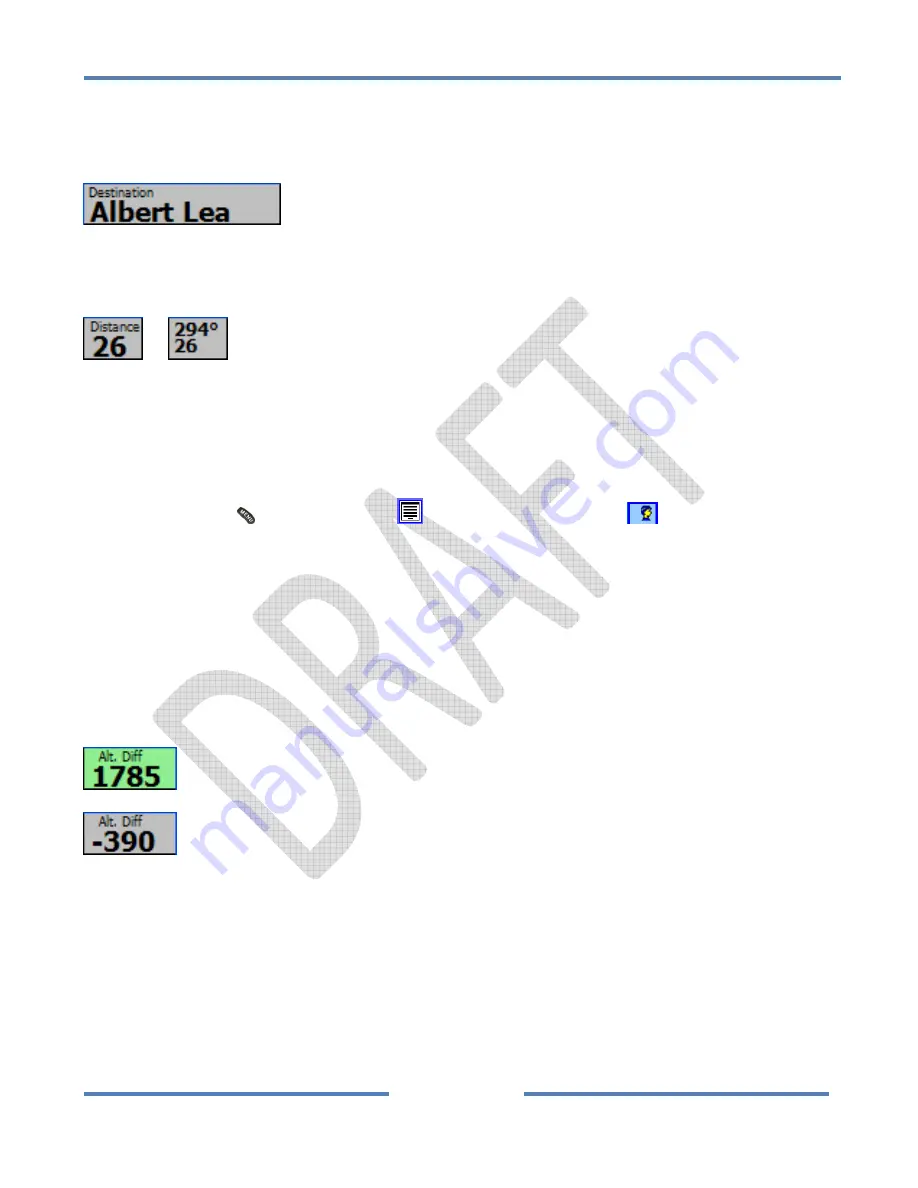
Destination


Window


The


Destination


Window


is


located


in


the


top


left


corner


of


the


moving


map


screen


and


shows


the


name


of


the


current


destination.


4.2.1.2


Distance


Window


or


The


Distance


Window


is


located


in


the


top


row


of


the


moving


map


screen,


between


the


Destination


and


Final


Glide


windows.


It


always


displays


the


distance


to


the


destination


and


can


optionally


display


the


both


the


distance


and


bearing


to


the


destination.


To


toggle


the


display


of


bearing


information


on


or


off:


Menu


button


/


Setup


Menu


Icon


/


Personal


Preferences


Tab


/


Map


Display


Options


/


Wind


&


Bearing


/


Bearing


Checkbox


4.2.1.3


Final


Glide


“Altitude


Differential”


Window


The


Final


Glide


Window


is


located


in


the


top


right


corner


of


the


moving


map


display.


The


label


“Alt.


Diff.”


(Altitude


Differential)


indicates


that


the


number


displayed


is


the


difference


between


the


altitude


required


to


make


it


to


the


destination


(taking


into


account


wind,


airspeed,


glider


polar,


MacCready


setting,


etc.)


and


your


current


altitude.


When


you


are


above


glideslope


the


number


will


be


greater


than


zero


and


the


box


will


be


colored


green.


When


you


are


below


glideslope


the


number


will


be


less


than


zero


and


the


box


will


be


grey


in


color.


1785


feet


or


meters


(depending


on


units


setup)


above


glideslope


390


feet


or


meters


(depending


on


units


setup)


below


glideslope


Note


on


MacCready


Setting


Changes


to


the


MacCready


setting


will


lead


to


changes


in


the


final


glide


altitude


differential


number.


Increasing


the


MacCready


number


will


indicate


that


you


should


be


flying


faster


and


have


higher


sink


rates


and


therefore


require


more


altitude


to


make


it


to


the


destination.


Generally,


new


cross

country


pilots


tend


to


bump


the


MacCready


value


down


to


zero


when


trying


to


decide


whether


they


can


make


it


home.


Their


reasoning


is


that


if


they


fly


more


slowly


they


may


be


able


to


make


it


home.


At


first


thought


this


seems


like


a


conservative


approach


because


they


are


Summary of Contents for ClearNav

Page 1: ...NK ClearNav Manual Version 0 5 July 3 2008 Page 1 of 86...

Page 2: ...NK ClearNav Manual Version 0 5 July 3 2008 Page 2 of 86...

Page 3: ...5 2 Fly Safely 12 1 5 3 Not a Certified Instrument 12 1 5 4 Warranty 12 1 5 5 Repairs 13 2 System Overview 13 2 1 Hardware 13 2 1 1 ClearNav Display 15 2 1 2 ClearNav Handheld Remote 16 2 1 3 ClearNav...

Page 4: ...ewport Peace sua files 30 2 3 2 2 OpenAir txt files 30 2 3 3 Worldwide Soaring Turnpoint Exchange 30 2 3 3 1 Downloading stx Waypoint Files from the Worldwide Soaring Turnpoint Exhange 30 2 3 3 2 Down...

Page 5: ...ut Button 36 4 1 3 Menu Button 37 4 1 4 Focus Button 38 4 1 5 Select Button 38 4 1 6 Arrow Buttons 39 4 2 Navigation Display moving map etc 40 4 2 1 Data at the Top of the Screen 41 4 2 1 1 Destinatio...

Page 6: ...67 4 2 4 The Selection Box 68 4 2 4 1 Pan the Moving Map Display 69 4 2 4 2 To View Data on a Nearby Turnpoint and Start Navigating to it 70 4 2 4 3 Create a Mark Point 71 4 2 4 4 To View or Disable...

Page 7: ...loading the Firmware and Software Upgrade Files to your Computer 82 5 3 2 Transferring Firmware and Software Files from the PC to the USB Flash Drive 82 5 3 3 Transferring Firmware Files from the USB...

Page 8: ...up 85 6 2 2 Enter a task or two 85 6 2 3 Fly a task 85 6 2 4 After landing transfer the flight log to the USB memory stick 85 6 3 Local Flying 85 6 3 1 Navigation to nearby airports 85 6 4 Setup and...

Page 9: ...NK Cle es The key f play of kes cities e e Calculator ange Amoeb e Range Ring MSL or AGL d Climb Meas imb Glide N verage Climb verage Glide ending GPS lator timization fe flight logs w ware that ma t...

Page 10: ...print Certainly the detailed instructions below are very clear and easy to follow but they use much more space than the Basic directions Below are examples of Basic and Detailed step by step instructi...

Page 11: ...Focus button to exit the menu and return to the moving map screen 1 4 Macintosh Computer Users This manual has been written for users of Windows PC computers However using a Macintosh to transfer wayp...

Page 12: ...ing flight It is not intended to replace your certified primary flight instruments It is not a replacement for good judgment which remains the responsibility of the pilot All calculations are only as...

Page 13: ...chantability or fitness for a particular purpose NK assumes no liability for any damages losses or expenses resulting directly or indirectly from product use 1 5 5 Repairs 2 System Overview The comple...

Page 14: ...NK ClearNav Manual Version 0 5 July 3 2008 Page 14 of 86...

Page 15: ...it 2 RS 232 serial ports for exchanging data with variometers FLARM units etc The connections to the RS 232 ports are on the Nexus Wiring Board 2 CAN bus ports for connection to remote controls and 2n...

Page 16: ...e it easy to quickly access any software feature The Handheld Remote connects to the ClearNav Display through the panel mounted connector on the CAN USB Extension It can also be connected directly to...

Page 17: ...the ClearNav system It connects to the ClearNav Display through a 15 pin D Sub connector that is located on the back of the ClearNav Display It includes a built in speaker and includes the 7 connecto...

Page 18: ...cludes the DB 15 connector that is used to connect to the ClearNav Display and sound holes for the speaker When mounting the ClearNav Display on the front of the instrument panel or recessed into the...

Page 19: ...0 5 July 3 2008 Page 19 of 86 When the ClearNav is mounted on a RAM mounting arm the Nexus Wiring Board is mounted behind the instrument panel and connected to the ClearNav Display using the DB15 Exte...

Page 20: ...ethod because it looks elegant The kit included an aluminum bezel standoffs support bracket and a yellow template to use when making the holes in the panel In the photos above the yellow template is u...

Page 21: ...partially block some instruments Most customers will find that mounting the ClearNav directly on the instrument panel makes for a cleaner and classier installation than the RAM arm option but those t...

Page 22: ...NK ClearNav Manual Version 0 5 July 3 2008 Page 22 of 86...

Page 23: ...d behind the panel The cable is a custom 14 conductor 2 cable with low profile DB15 female connector The cable is extremely flexible and has an abrasion resistant jacket The cable is run through a 3 8...

Page 24: ...Antenna The ClearNav has a built in GPS engine but an external antenna is required It is included in the standard ClearNav kit It consists of an amplified external GPS antenna and Dual Lock mounting...

Page 25: ...1 25 mm round hole in the panel The USB connector is used as a receptacle for a USB Flash Drive for transferring flight logs from the ClearNav and uploading waypoint and airspace files and software u...

Page 26: ...s to have plenty of memory A 2 GB Flash Drive would hold all the maps airspace elevation data etc for the entire world At the time of this writing 20 would get me a 4 GB Flash Drive on Amazon com It d...

Page 27: ...irspeed to the GPS measured speed and direction Without the 302 the ClearNav calculates wind using wind drift while circling To display the Real Time Headwind received from the 302 simply enable that...

Page 28: ...is shown below 2 2 Software The ClearNav runs ClearNavigator software that is specifically designed to work with the ClearNav s unique remote control and other hardware No other soaring software will...

Page 29: ...points directory on the USB Flash Drive or SD memory card The files will be pulled into the ClearNav upon start up 2 3 1 1 Worldwide Soaring Turnpoint Exchange stx files The best type of waypoint file...

Page 30: ...dwide Soaring Turnpoint Exchange The Worldwide Soaring Turnpoint Exchange is a fantastic site that was created by and is maintained by John Leibacher It is so important to soaring pilots around the wo...

Page 31: ...pcoming soaring contest site follow the directions below 1 Go to the Worldwide Soaring Turnpoint Exchange using one of the 3 links above http soaringweb org is the main site Note that there is no www...

Page 32: ...ed into the ClearNav and stored on the provided USB Flash Drive The elevation data is stored in the Globe directory on the USB Flash Drive 2 3 5 Shape Data Cities Rivers Lakes and Roads etc Shape data...

Page 33: ...ge 33 of 86 3 Installation 3 1 ClearNav Display 3 1 1 On Front of Panel 3 1 2 Recessed into the Panel 3 1 3 On a RAM Mounting Arm 3 2 GPS Antenna 3 3 Handheld Remote Control 3 4 Stick Mounted Remote C...

Page 34: ...in turbulent air and when wearing gloves They have a very positive click feel and sound which make it clear when a button has been pressed and released They also stand out from the remote which makes...

Page 35: ...mote it makes sense just push the forward button as if you were pushing the stick forward to get closer to the earth The rectangular Selection Box in the middle of the moving map display shows the cur...

Page 36: ...the remote it makes sense just push the back button as if you were pulling the stick back to climb away from the earth The rectangular Selection Box in the middle of the moving map display displays th...

Page 37: ...tton once to make the Ribbon Menu appear Press the Menu button a 2nd time to hide the Ribbon Menu The Ribbon Menu The Ribbon Menu as it appears near the top of the moving map display when the Menu but...

Page 38: ...the screen that has the focus Changing the active item on the moving map using the Focus button Shifting focus to any item on the screen is temporary For example the Numeric Information Area will lose...

Page 39: ...9 of 86 4 1 6 Arrow Buttons The Arrow buttons are used to navigate up down and across menus and to move the Selection Box to go to or view data on nearby airports or airspace The 4 Arrow buttons inclu...

Page 40: ...NK ClearNav Manual Version 0 5 July 3 2008 Page 40 of 86 4 2 Navigation Display moving map etc Overview of the data on the map...

Page 41: ...indicates that the number displayed is the difference between the altitude required to make it to the destination taking into account wind airspeed glider polar MacCready setting etc and your current...

Page 42: ...altitude before starting your final glide which will allow you to slow down to stretch your glide in the future if necessary or speed up in sink and still have enough extra altitude to make it home In...

Page 43: ...ll times For example the Simulator Icon is only displayed when in simulator mode Also the Ribbon Options Menu can be used to disable icons that you don t use often 4 2 2 1 Select Destination Icon The...

Page 44: ...on can be used to jump up through the list one screen at a time The Zoom Out button can be used to jump down through the list one screen at a time Press the Select button to select he highlighted wayp...

Page 45: ...cified in the polar settings screen When the Water Ballast icon is highlighted you can begin editing of the number by pressing either the Select Up or Down button You would think that you would need t...

Page 46: ...tes the selected mode Press the Select Menu or Focus button to accept the highlighted selection and return to the moving map screen 4 2 2 5 Backlight Intensity Icon The Backlight Intensity Icon is use...

Page 47: ...n to select the desired Light Intensity setting Press the Select Menu or Focus button to accept the highlighted selection and return to the moving map screen 4 2 2 6 Task Edit Icon The Task Edit Icon...

Page 48: ...bably recommend keeping the information on the map to a minimum to reduce screen clutter and reduce the amount of time spent staring at the map when your eyes should be looking out the window for traf...

Page 49: ...will opt to turn off the display of terrain data especially when flying in flat regions to improve the contrast of the display and to reduce screen clutter Culture Culture data includes cities and ro...

Page 50: ...or your glider you may have an interesting landing It is your job to assure that the data in the waypoint file is correct Tracks The Tracks checkbox is used the enable or disable the display of glider...

Page 51: ...imulator Controller is displayed The Simulator Icon is only visible when in Simulator mode Simulator mode can be entered upon startup or using the Menu button Setup Menu Icon Tools Tab Simulator butto...

Page 52: ...sure that everything is set to match your preferences Details on the parameters in every Setup Menu are available here The Setup Menus are arranged into 6 tabs The Left and Right buttons are used to s...

Page 53: ...s to display in the Ribbon Menu The Ribbon Options Menu The Up and Down buttons are used to move through the options and the Select button is used to toggle the checkboxes on and off To exit the Ribbo...

Page 54: ...windows The Task Window is also used to start tasks move through task legs and toggle the Final Glide Window display between glide to the next waypoint or glide to the end of the task The Numeric Info...

Page 55: ...t and it will hide automatically in about 30 seconds 4 2 3 2 Glide Wind Window The Glide Wind Window is found in the lower left corner of the moving map screen to the right of the MacCready Window The...

Page 56: ...ownside is that the text size must be reduced to fit both the Wind Speed and the Wind Direction into the Glide Wind Window To enable or disable the Numeric Wind Direction option Menu button Setup Menu...

Page 57: ...Wind Mode but it is not necessary You can simply go directly to the Wind Direction and Wind Speed numbers As soon as you edit one of them the mode will automatically change to Manual Wind Mode Changin...

Page 58: ...ween the 2 numbers automatically as you change flight modes such as changing from Cruise to Climb mode or vice versa There is a delay of a few seconds as you transition between flight modes because it...

Page 59: ...ended MacCready setting Average Glide Netto This is the average netto climb or sink achieved in all glides since take off or since the start of the task The number is automatically reset when the task...

Page 60: ...in the Vario Settings Set Window for your current location otherwise the Time of Day will not display correctly 4 2 3 4 Task Window The Task Window or or or or is located near the right side of the bo...

Page 61: ...Time To Finish This number is extremely useful when flying tasks that have a minimum task time You may want to display this number when flying contest tasks As long as the Total Time is longer than t...

Page 62: ...ask Time If You Turn Here is 3 to 5 minutes over the minimum task time to make sure you make sure you don t get home early The screen image below should help clarify the 2 numbers The time numbers are...

Page 63: ...used to select the data to display in the Task Window and to view the active task You can also view all the available parameters in one screen even the parameters that are not selected for display on...

Page 64: ...the calculated ideal turnpoint Resume Task Button The Resume Task button is used to resume the task after it has been suspended The task is suspended any time you start navigating to a non task turnp...

Page 65: ...g the remainder of the task That is because you will not be stopping to thermal when on final glide which will make your average speed go up significantly for the last part of the task The Predicted S...

Page 66: ...yed on the far right edge of the screen The manually entered number is displayed in an edit box to the left of the automatically calculated number In Using Auto mode the calculated speed is automatica...

Page 67: ...ght Pressure Altitude The Pressure Altitude is the raw altitude from the pressure transducer and shows the altitude in a standard atmosphere Since the local barometric pressure is not likely to match...

Page 68: ...b Use the Left and Right buttons to switch between the Alt and Set MSL tabs Press the Select button to activate the selected function or edit the highlighted numeric data Press the Menu Focus or butto...

Page 69: ...he Moving Map Display To Pan the map screen is to move it around as if sliding a map across the top of a table so you can see regions of the map that were not previously in view To Pan the moving map...

Page 70: ...s OK to have multiple turnpoints in the box as you will get the opportunity to select the desired turnpoint from a list of the turnpoints that are in the box You can pan the map in any direction by mo...

Page 71: ...ossible to create a task using Mark Points Every time you add a new Mark Point it is saved into the current waypoint file so that it will appear the next time you fly Each new Mark Point is given a ne...

Page 72: ...3 2008 Page 72 of 86 Use the Up Down buttons to select Mark Point at the bottom of the list of turnpoints Press the Select button to mark the point Use the Left and Right buttons to select Yes to save...

Page 73: ...Use the Up Down Left and Right buttons to move the Selection Box over the desired airspace section It is OK to have multiple airspace sections in the box as you will get the opportunity to select the...

Page 74: ...ed airspace section is shown at the bottom of the screen Press the Select button to disable the selected airspace for 12 hours A confirmation dialog will give you the option to continue or cancel see...

Page 75: ...se the Down button to move down to the 12 Hour Off List item Press the Select button The 12 Hour Off List will be displayed Use the Up Down buttons to select the airspace you want to re enable Press t...

Page 76: ...itudes for each Glide Amoeba are adjustable There is also an optional MSL Altitude Glide Ring which is described in the next section Example showing the Glide Amoebae in mountainous terrain As you can...

Page 77: ...s are based on total energy final glide As you fly faster your glider has more energy and could pull up to gain altitude and range For example if 2 identical gliders were at the same location and alti...

Page 78: ...NK ClearNav Manual Version 0 5 July 3 2008 Page 78 of 86...

Page 79: ...n altitude that is higher than the user selected MSL Altitude entered for the MSL Altitude Glide Ring As you increase the number entered in the MSL Altitude the ring will get closer to the glider beca...

Page 80: ...learNav Manual Version 0 5 July 3 2008 Page 80 of 86 To access the settings for the MSL Glide Ring go to Menu button Setup Menu Icon Personal Preferences Tab Final Glide Settings 4 2 7 Area Task Blue...

Page 81: ...files Windows will open the Windows Explorer My Computer program and display the files on the USB Flash Drive You can then copy the files onto your computer s hard drive We recommend copying the fligh...

Page 82: ...actory But today firmware and software can often be downloaded from the internet and transferred to a device to give it new functionality That is an advantage for those of us using the products becaus...

Page 83: ...Transferring the firmware and software files from the USB Flash Drive to the ClearNav is very easy 1 Power down the ClearNav 2 Plug the USB Flash Drive into the ClearNav s panel mounted USB connector...

Page 84: ...oint file 6 1 4 Select desired airspace file 6 1 5 Set UTC Time offset in the NIA info Set window 6 1 6 Setup Pilot Preferences in the Pilot Preferences menu 6 1 6 1 Pilot Name 6 1 6 2 Final Glide Set...

Page 85: ...er a task or two 6 2 3 Fly a task 6 2 4 After landing transfer the flight log to the USB memory stick 6 3 Local Flying 6 3 1 Navigation to nearby airports 6 4 Setup and Fly a Badge or Record Task 6 5...

Page 86: ...NK ClearNav Manual Version 0 5 July 3 2008 Page 86 of 86...

Reviews: