


Mini-X Installation, Setup & User Manual GRT Avionics
Revision A9 51
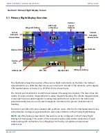
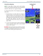
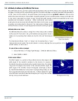
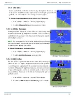
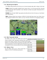
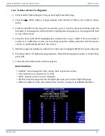
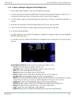
5.9.5 Waypoint Balloons
Waypoint balloons are markers that highlight the next GPS waypoints in the flight plan on the PFD.
They have a “tether” that points directly downward to the waypoint and are raised and lowered
with the altitude bug. They are visible beyond the 30-mile horizon line; in that case, they do not
have a tether (as shown to the right). In an enroute crosswind situation, keep the flight path marker
on the waypoint balloon to fly directly to the waypoint. The active waypoint balloon is magenta.
Subsequent waypoints in the flight plan are white.
To turn on waypoint balloons:
1. Press MORE > Set Menu > Primary Flight Display.
2. Scroll to
Waypoint Balloons
and select ON or OFF.
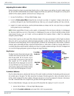
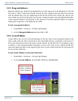
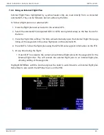
5.9.6 Course Ribbons
Course ribbons are a form of enroute Highway-In-The-Sky. They connect waypoint balloons and
draw a path in the sky that corresponds to the active flight plan leg- essentially, a 3D version of
the course lines drawn on the map screen. Course ribbons can take the form of a magenta course
centerline or dual magenta-shaded boundaries on each side of the course, starting at 200 feet
apart and tapering inward as the waypoint gets closer. Course ribbons beyond the next waypoint
show as white centerlines.
To turn course ribbons on and select their form:
1. Press MORE > Set Menu > Primary Flight Display.
2. Scroll to
Course Ribbons
. Select NONE, CENTER or BOUNDARIES.
Active leg of flight
plan denoted by
course ribbon
(“boundary” is shown)
Magenta waypoint
balloon marks the
active waypoint


