


Garmin GPSMAP 695/696 Owner’s Manual
190-00919-00 Rev. D
46
GPS Navigation
Overview
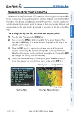
GPS Navigation
Flight Planning
Hazar
d
Avoidance
Additional F
eatur
es
Appendices
Index
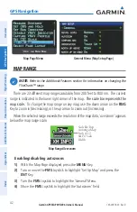
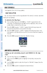
tOPOGraPhy
Topographic data can be displayed or removed as described in the following
procedures.
Displaying/removing topographic data:
1)
Press the
MAP
Softkey on the Map Page. Press the
vFR MAP
Softkey if
necessary.
2)
Press the
TOPO
Softkey. Topographic data is displayed.
3)
Press the
TOPO
Softkey again to remove topographic data from the
Navigation Map.
Or
:
1)
From the Map Page, press the
MENU
Key.
2)
Turn or move the
FMS
Joystick to highlight ‘Set Up Map’, and press the
ENT
Key.
3)
Turn the
FMS
Joystick to highlight the ‘Map’ Category from the horizontal
list.
4)
Move the
FMS
Joystick to highlight the ‘Topo Shading’ field.
5)
Turn the
FMS
Joystick to select ‘On’ or ‘Off’, and press the
ENT
Key.
Topographic Data (Map Page)
TOPO Softkey
VFR MAP Softkey
Summary of Contents for GPSMAP 695
Page 1: ...GPSMAP 695 696 Owner s Manual Portable Aviation Receiver...
Page 2: ......
Page 3: ...Overview GPS Navigation Flight Planning Hazard Avoidance Additional Features Appendices Index...
Page 4: ......
Page 10: ...Garmin GPSMAP 695 696 Owner s Manual 190 00919 00 Rev D Warnings Cautions Notes Blank Page...
Page 209: ......