


Garmin GPSMAP 695/696 Owner’s Manual
190-00919-00 Rev. D
31
GPS Navigation
Overview
GPS Navigation
Flight Planning
Hazar
d
Avoidance
Additional F
eatur
es
Appendices
Index
DATA BAR FIElD OPTIONS
• Accuracy
• Altitude
• Bearing (BRG)
• Course (DTK)
• Course to Steer (CTS)
• Crosstrack Error (XTK)
• Distance (DIS)
• Enroute Safe Altitude (ESA)
• Estimated Time Enroute (ETE)
• Estimated Time of Arrival (ETA)
• Estimated Time to VNAV (VNAV
Time)
• Flight Timer (FLT TIMER)
• Fuel Timer
• Glide Ratio (G/R)
• Ground Speed (GS)
• Ground Track (TRK)
• Minimum Safe Altitude (MSA)
• Next Waypoint (WPT)
• Sunrise
• Sunset
• Time (UTC)
• Time of Day (Local) (TIME)
• Vertical Speed (VS)
• Vertical Speed Required (VSR)
• Volts
• Weather (Altimeter) (WX ALTIM)
• Weather (Dew Point) (WX DEW
PT)
• Weather (Pressure) (WX PRESS)
• Weather (Relative Humidity) (WX
HUMIDITY)
• Weather (Temperature) (WX
TEMP)
• Weather (Wind) (WX WIND)
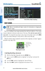
Changing page layout:
1)
From the Map Page, Terrain Page, or the Info Page press the
MENU
Key.
2)
Turn or move the
FMS
Joystick to highlight ‘Select Page Layout’ and press
the
ENT
Key.
3)
Move the
FMS
Joystick to highlight the desired page layout option, and
press the
ENT
Key.
Summary of Contents for GPSMAP 695
Page 1: ...GPSMAP 695 696 Owner s Manual Portable Aviation Receiver...
Page 2: ......
Page 3: ...Overview GPS Navigation Flight Planning Hazard Avoidance Additional Features Appendices Index...
Page 4: ......
Page 10: ...Garmin GPSMAP 695 696 Owner s Manual 190 00919 00 Rev D Warnings Cautions Notes Blank Page...
Page 209: ......