


Garmin GPSMAP 695/696 Owner’s Manual
190-00919-00 Rev. D
40
GPS Navigation
Overview
GPS Navigation
Flight Planning
Hazar
d
Avoidance
Additional F
eatur
es
Appendices
Index
•
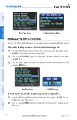
By—Enter the target location with settings of distance ‘Before’ or ‘After’ a
reference waypoint. To set a target location at a reference waypoint, enter a
distance of zero.
•
VNAV Messages—Select ‘On’ or ‘Off’ to enable/disable VNAV alert messages.
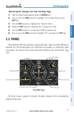
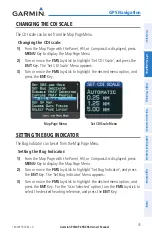
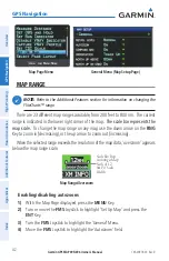
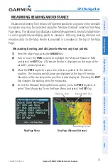
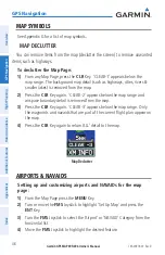
2.4 uSiNG MaP diSPlayS
Map displays are used extensively in the GPSMAP 695/696 to provide situational
awareness in flight. Most GPSMAP 695/696 maps can display the following
information:
• Airports, NAVAIDs, airspaces, airways, land data (highways, cities, lakes, rivers,
borders, etc.) with names
• Map Pointer information (distance and bearing to pointer, location of pointer,
name, and other pertinent information)
• Map range
• Aircraft icon (representing present position)
• Flight plan legs
• User waypoints
• Track vector
• Topography data
The information in this section applies to the following maps unless otherwise
noted:
• Map Page (MAP)
• Waypoint Page (WPT) (
INFO
Softkey selected)
• Weather Page (WX)
• Terrain (TER)
• Nearest Pages (NRST)
• Active Flight Plan Page (FPL)
• Direct-to Window (map range only)
Summary of Contents for GPSMAP 695
Page 1: ...GPSMAP 695 696 Owner s Manual Portable Aviation Receiver...
Page 2: ......
Page 3: ...Overview GPS Navigation Flight Planning Hazard Avoidance Additional Features Appendices Index...
Page 4: ......
Page 10: ...Garmin GPSMAP 695 696 Owner s Manual 190 00919 00 Rev D Warnings Cautions Notes Blank Page...
Page 209: ......