- 5 -
PLOTTER SPECIFICATION
Drawing Method : Mercator Drawing
Scale Range : 1/2,500 ~ 1/37,500,000 (about 0.2nm ~ 5,000nm)
Effective Display Range : Less than Latitude 85°
Menu : Pull-down Menu System
Coast Line Chart : FUSO ORIGINAL MAP
Display on the Tracking Screen
C-MAP (possible to use by purchase)
Track Display : Memory Interval – Stop Track Memory,
1 sec. ~ 60 min. available to do variable selection
0.01nm ~ 9.99nm available to do variable selection
Memory Capacity - Track 20,000 points
Track Mark – 100 points
Track Color – 16 colors
Mark Display : Mark type
–
21 types
Color - 16colors
Memory - 10,000points, Distinguish color & delete
User’s Line Drawing Mark 9,980 points
Waypoint & Route Memory : 20 routes(1 route/20 points)
possible to use both-way
PLOTTER FUNCTION
Auxiliary Memory Unit : Coast Line, TRACK, Event, Waypoint,
User’s Line to be saved.
Disk save .SD card, C-User card available.
Data display : Target, Cursor(Distance, Latitude, Longitude), Time,
Course/Speed,
Distance, Interim Waypoint, Bearing/Distance, time,
Warning Line,
Course Break Steering, Depth line of Sea, Fill Land,
Ocean Deep, Sinking Ship/Undersea grasses,
Own ship, Zoom in/out
Alarm
: Arrival Alarm, Course Break, Anchor Alarm, Boundary
Submarine cable
Geodetic Datum : Selectable Datum in worldwide
Navigation data input/output format : Output/Input
(
Other brand’s equipment available
)
Summary of Contents for FEG-881
Page 1: ...FEG 881OPERATION MANUAL 8 INCH COLOR GPS PLOTTER FISH FINDER...
Page 5: ...1 This chapter provides an overview of the GLOBAL POSITIONING SYSTEM GPS 1 GPS PLOTTER...
Page 21: ...17 Day Night Mode in Plotter Display Press Open the menu such as Transparency Day Night mode...
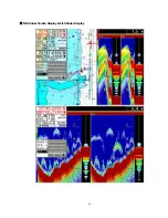
Page 23: ...19 Fish finder Combo Display Fish finder Display...
Page 105: ...101 APPENDIX 2 CONNECTING PINS...
Page 106: ...102 DIMENSIONS need more than 100mm for service space in main body rear unit mm...
Page 107: ...103 INSTALLING TO THE MAIN BODY...
Page 111: ...107...

