


134
the map, but the closer it is to your location, the smaller the numbers
you'll have to manipulate.
Once you've decided on a reference position, you can save it as a
waypoint. See the waypoint section for information on saving a
waypoint. Save the reference position as a waypoint. Exit from the
waypoint screens.
1. Press
MENU
|
MENU
|
↓
to
GPS S
ETUP
|
ENT
.
2. Press
↓
to
C
OORDINATE
S
YSTEM
|
ENT
.
3. Press
↓
to
S
ETUP
M
AP
F
IX
|
ENT
.
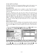
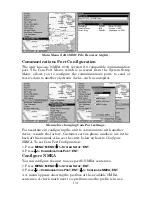
The following screen appears, and
M
AP
S
CALE
is highlighted. Press
ENT
and enter the map's scale. This is generally at the bottom of the paper
map. It's shown as a ratio, for example 1:24000. Press
EXIT
and the unit
returns to the Configure Map Fix screen.
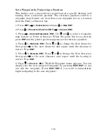
Configure a map fix so the unit can find your
position on a printed chart or topographical map.
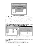
Press
↓
to
S
ELECT
O
RIGIN
W
AYPOINT
|
ENT.
Press
→
to saved then press
ENT
|
ENT
|
ENT.
Use
↓
or
↑
to choose a saved waypoint. Select the
waypoint you saved the reference point under and press
ENT
. The unit
displays a waypoint information screen with
S
ET
A
S
O
RIGIN
selected.
Press
ENT
and the unit returns to the Configure Map Fix menu.
Finally, press
EXIT
to close this menu. Now press
↑
to
C
OORD
S
YSTEM
|
ENT
, select
M
AP
F
IX
from the list and press
ENT
|
EXIT
|
EXIT
|
EXIT
.
All position information now shows as a distance from the reference
point you chose.
Customize Page Displays
Several page display options have customizable data boxes to provide
constant on-screen information.
Summary of Contents for FishStrike 2000
Page 46: ...38 Notes ...
Page 96: ...88 Notes ...
Page 172: ...164 Notes ...
Page 192: ...184 Notes ...
Page 197: ...189 Notes ...
Page 198: ...190 Notes ...