


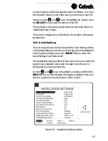


67
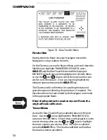
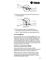
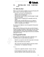
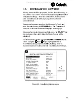
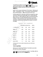
b) The vessel starts to pass the Target Waypoint at a
perpendicular distance greater then 0.05 nautical miles.
Figure 37 - Route Following: Automatic Waypoint Arrival
Course and Bearing
This setting allows you to choose between Magnetic or True
bearings and courses for use on the Chartnavs displays and in
calculations. Please note, however, that Magnetic Bearings
are only available whilst a data card is being used. Once the
Chartnavs internal maps or the basic world map are used the
Chartnav will default to True Bearings. A Pop-Up Window will
be displayed to warn of this change.
Fix Datum and Chart Datum WGS84
As the earth is neither smooth nor exactly spherical
Navigational charts have been drawn using various theoretical
models of the earths surface, often for localised areas.
With the advent of GPS, which is a global system, a global
model of the earths surface was required. WGS84 (World
Geodetic System 1984) is the latest model which is used by
most modern navigation receivers.
Target waypoint
Track
Arrival Alarm Sounds
0.05 NM
Automatically Switches to
next Waypoint at 0.05 NM
Target waypoint
Desired Track
Actual Track
Arrival Alarm Sounds
0.05 NM
Automatically Switches to
next Waypoint at distance
greater than 0.05 NM
a) The vessels position arrives within 0.05 nautical miles of
the Target Waypoint.
All manuals and user guides at all-guides.com


