
31
Horizon GPS Chart400 User Manual
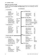
5.0
Specification
Waypoints:
500, automatic naming or user entry (alpha-numeric).
Routes:
25 reversible with up to 50 points each.
Plotter Log:
plots by time or distance, saves up to 2000 points
Alarms:
Arrival, Anchor, and Guard zone, individually controlled.
Map Datum’s:
128
Mapshift:
one user defined.
Data Format:
C-MAP
TM
NT format.
Data Cartridges:
C-MAP
TM
NT-Cards (16Mbit memory, 48Mbit max).
Plotting Scales:
1/8 nm to 4096 nm with push-button zoom (chart dependent).
Operation Features: One button Boat or Cursor re-centering.
Dual Speed, 8-way Cursor control.
Interfaces
DGPS Input: NMEA 0183 / RTCM 104 ver 2.0
Autopilot Output: NMEA 0183
Physical characteristics
Chartplotter
Size:
138 mm H x 180 mm W x 67 mm D (5.4” x 7.1” x 2.6”)
Weight:
0.62 kg
Display:
90 mm H x 120 mm W (3.5” x 4.75”)
Operating Voltage:
11.0 - 16.5 VDC
Power Use:
60mA Typical (Backlight Off)
Operating Temperature:
0°C - 50°C (32°F - 122°F).
Display Matrix:
240 x 180 pixels
Display Type:
STN Temperature Compensated