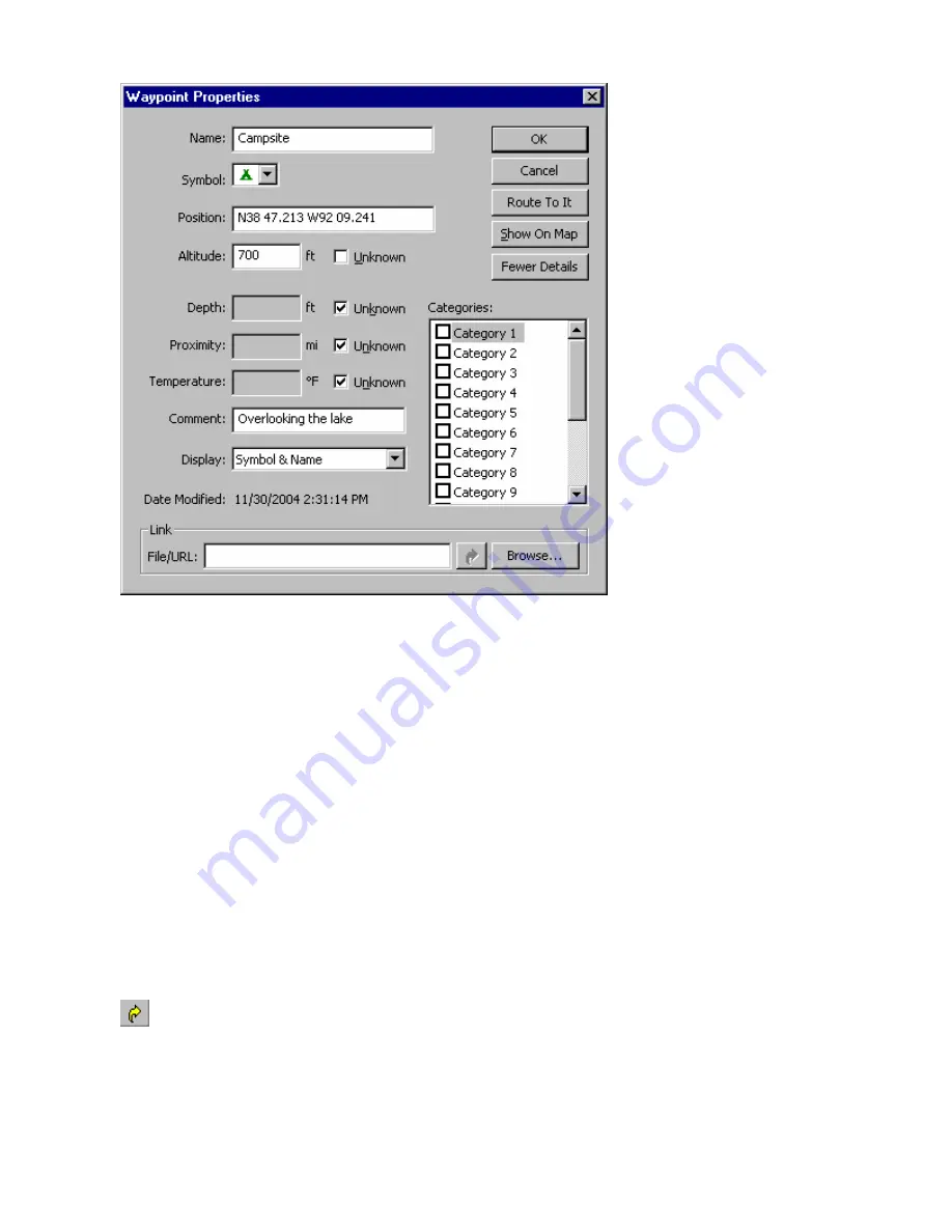
Depth
—enter the depth or leave the default
Unknown
box checked.
Proximity
—enter the range for a proximity warning or leave the default
Unknown
box checked. (This
property is not used by all Garmin GPS systems.)
Temperature
—enter a temperature or leave the default
Unknown
box checked.
Comment
—enter a comment about the waypoint, if desired. If you mark an existing map feature as a
waypoint, nRoute includes the name of the feature in the Comment field. If you create a waypoint at a
location with no existing map features, the Comment field defaults to the date and time the waypoint was
created.
Display
—select the method for displaying the waypoint on the map: symbol, symbol & name, or symbol &
description. You can change the default display setting in the Waypoint Preferences window.
Date Modified
—the date and time the waypoint was created or modified (if available).
Categories
—to assign this waypoint to a Waypoint Category, check the appropriate box. You can assign
a waypoint to as many categories as desired. See Creating Waypoint Categories for more information.
Link
—this feature allows you to include a link to a file or URL containing information related to the
waypoint. For example, you could link to an electronic document containing a description of your waypoint,
a digital photo you took while at the waypoint, or a Web site devoted to the area around the waypoint. You
can enter the desired file name/URL or click
Browse
to select the desired file. Click the
Open Link
button
to activate the link.
4. Click
OK
. Your changes are saved.
60
Содержание GPS 18 - Deluxe USB Sensor
Страница 1: ...nRoute GPS navigation software help contents ...
Страница 32: ...Legend of Map Symbols Legend Businesses and Attractions 30 ...
Страница 33: ...Legend Points of Interest 31 ...
Страница 34: ...Legend Map Lines 32 ...
Страница 35: ...Legend Map Areas 33 ...
Страница 41: ...39 ...
Страница 43: ...41 ...
Страница 82: ...7 Click Close to exit the Vertical Profile window 80 ...
Страница 129: ......


