Garmin G950 Pilot’s Guide for the Pilatus PC-6
190-00870-02 Rev. A
250
FLIGHT MANAGEMENT
SY
STEM
O
VER
VIEW
FLIGHT
INSTRUMENTS
EIS
AUDIO P
ANEL
& CNS
FLIGHT
MANA
GEMENT
HAZARD
AV
OID
ANCE
AFCS
ADDITIONAL FEA
TURES
APPENDICES
INDEX
5.9 TRIP PLANNING
The G950 allows the pilot to view trip planning information, fuel information, and other information for a
specified flight plan or flight plan leg based on automatic data, or based on manually entered data. Weight
planning is also available, based on fuel data and the active flight plan (to estimate remaining fuel).
TRIP PLANNING
All of the input of data needed for calculation and viewing of the statistics is done on the Trip Planning Page
located in the AUX Page Group.
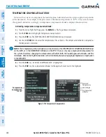
Figure 5-106 Trip Planning Page
Trip Statistics
Desired Track -
Distance -
Est. Time Enroute -
Est. Time of Arrival -
Enroute Safe Altitude -
Sunrise Time (local) -
Sunset Time (local) -
Trip Input Data (sensor/pilot)
- Departure Time (local)
- Ground Speed
- Fuel Flow
- Fuel On Board Aircraft
- Calibrated Airspeed
- Indicated Altitude
- Barometric Pressure
- Total Air Temperature
Softkeys
- Automatic/Manual Page Mode
- Flight Plan/Waypoint Mode
Preview of Selected
Flight Plan/
Flight Plan Leg
Trip Planning Page Mode
- Automatic/Manual
Selected Flight Plan Segment
- FPL Number/Cumulative Legs (CUM or REM) or Leg Number (NN)
- Waypoints Defining Selected Flight Plan/Flight Plan Leg
Fuel Statistics
Efficiency -
Total Endurance -
Remaining Fuel -
Remaining Endurance -
Fuel Required -
Total Range -
Other Statistics
- Density Altitude
- True Airspeed (TAS)
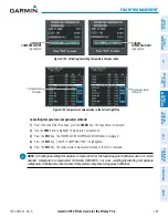
The trip planning inputs are based on sensor inputs (automatic page mode) or on pilot inputs (manual page
mode). Some additional explanation of the sources for some of the inputs is as follows:
• Departure time (DEP TIME) - This defaults to the current time in automatic page mode. The computations
are from the aircraft present position, so the aircraft is always just departing.
• Calibrated airspeed (CALIBRATED AS) - The primary source is from the air data system, and the secondary
source of information is GPS ground speed.
• Indicated altitude (IND ALTITUDE) - The primary source is the barometric altitude, and the secondary source
of information is GPS altitude.


