


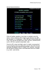


IFD500 Series Pilot Guide
General 7-55
FIS-B WEATHER
FIS-B information may be used for pilot planning decisions
focused on updating the pilot's awareness of the dynamic flight
environment; including avoiding areas of inclement weather that
are beyond visual range and pilot near term decisions where poor
visibility precludes visual acquisition of inclement weather. FIS-B
weather and NAS status information may be used as follows:
(a) To promote pilot awareness of ownship location with
respect to reported weather, including hazardous
meteorological conditions; NAS status indicators to
enhance pilot planning decisions; and pilot near-term
decision-making.
(b) To cue the pilot to communicate with Air Traffic Control,
Flight Service Station specialist, operator dispatch, or
airline operations control center for general and mission
critical meteorological information, NAS status conditions,
or both.
FIS-B information, including weather information, NOTAMs, and
TFR areas, are intended for the sole purpose of assisting in long-
and near-term planning and decision making. The system lacks
sufficient resolution and updating capability necessary for aerial
maneuvering associated with immediate decisions.
In particular, in extreme scenarios, the oldest weather radar data
on the display can be up to 15 to 20 minutes older than the
display's age indication for that weather radar data. Therefore, do
not attempt to use FIS-B weather information to maneuver the
aircraft at minimum safe distances from hazardous weather. FIS-
B information may be used to support preflight preparation
required by regulation. However, depending on the intended
operation, FIS-B may not provide all available aeronautical or
meteorological information concerning the flight. Regulatory
compliant preflight preparation may be accomplished using
automated resources or by contacting Flight Service.
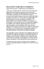
FIS-B uplink is an FAA approved source for METAR, TAF, Winds,
PIREPs, NEXRAD, AIRMET, SIGMET, and TFR information
subject to the range limits for the broadcast of these products.
FIS-B uplink is not an FAA approved source for NOTAMs.
Содержание IFD510
Страница 1: ......
Страница 75: ...IFD500 Series Pilot Guide SVS Subsystem 2 9 Yellow Obstacle Threat Bubble Red Obstacle Threat Bubble ...
Страница 140: ...IFD500 Series Pilot Guide 3 50 FMS Subsystem Weather Data on Info Tab Info Tab Nearby Navaids ...
Страница 150: ...IFD500 Series Pilot Guide 3 60 FMS Subsystem User Waypoint Airfield Naming Example ...
Страница 156: ......
Страница 180: ...IFD500 Series Pilot Guide 4 24 Map Subsystem ADS B Lightning Coverage Area Shadow ...
Страница 217: ...IFD500 Series Pilot Guide Map Subsystem 4 61 Map SVS Fly By Waypoint Depiction Map SVS Missed Approach Not Activated ...
Страница 218: ...IFD500 Series Pilot Guide 4 62 Map Subsystem Map SVS Close in of Landing Runway Map SVS Missed Approach Enabled ...
Страница 252: ...IFD500 Series Pilot Guide 5 16 Aux Subsystem Trip Statistics Calculator ...
Страница 369: ...IFD500 Series Pilot Guide Navigation 6 33 Enable Missed LSK Enabled Missed Approach in Flight Plan ...
Страница 459: ...IFD500 Series Pilot Guide General 7 81 Bluetooth pairing keyboard discovered Bluetooth pairing Pair Device LSK ...
Страница 460: ...IFD500 Series Pilot Guide 7 82 General Bluetooth pairing pairing code ...