


IFD500 Series Pilot Guide
6-38 Navigation
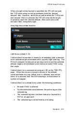
active enroute VNAV altitude target. Note that if the constraint is
a window constraint, the lower altitude is used as the target.
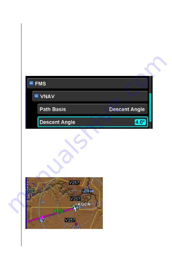
DEFINING THE DESCENT PATH
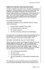
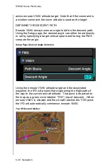
Enroute VNAV always uses an angle to define the descent path.
Using the Setup page, the desired angle can either be set directly
or set by specifying a target vertical speed and having the FMS
compute the angle.
Setup Page Descent Angle Selection
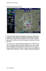
Using the enroute VNAV altitude target and the associated
waypoint, the IFD will project that angle along the flight path all
the way to the current aircraft altitude. That point is depicted on
the map as a green circle labeled “TOD” (top-of-descent). When
enroute VNAV is allowed and the aircraft reaches the TOD point,
the IFD will automatically commence enroute VNAV.
Top Of Descent Marker
Содержание IFD510
Страница 1: ......
Страница 75: ...IFD500 Series Pilot Guide SVS Subsystem 2 9 Yellow Obstacle Threat Bubble Red Obstacle Threat Bubble ...
Страница 140: ...IFD500 Series Pilot Guide 3 50 FMS Subsystem Weather Data on Info Tab Info Tab Nearby Navaids ...
Страница 150: ...IFD500 Series Pilot Guide 3 60 FMS Subsystem User Waypoint Airfield Naming Example ...
Страница 156: ......
Страница 180: ...IFD500 Series Pilot Guide 4 24 Map Subsystem ADS B Lightning Coverage Area Shadow ...
Страница 217: ...IFD500 Series Pilot Guide Map Subsystem 4 61 Map SVS Fly By Waypoint Depiction Map SVS Missed Approach Not Activated ...
Страница 218: ...IFD500 Series Pilot Guide 4 62 Map Subsystem Map SVS Close in of Landing Runway Map SVS Missed Approach Enabled ...
Страница 252: ...IFD500 Series Pilot Guide 5 16 Aux Subsystem Trip Statistics Calculator ...
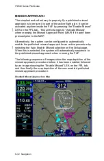
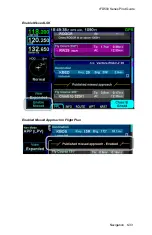
Страница 369: ...IFD500 Series Pilot Guide Navigation 6 33 Enable Missed LSK Enabled Missed Approach in Flight Plan ...
Страница 459: ...IFD500 Series Pilot Guide General 7 81 Bluetooth pairing keyboard discovered Bluetooth pairing Pair Device LSK ...
Страница 460: ...IFD500 Series Pilot Guide 7 82 General Bluetooth pairing pairing code ...