


14
3.1 Map a Mission
3.11 Overview
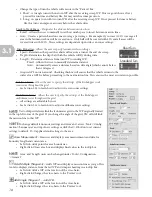
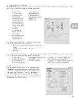
EcoMapper’s mission planning software, VectorMap, utilizes georeferenced maps to establish waypoints to guide the
vehicle via GPS signal. In order to plan a mission, you must first have a digital copy of a georeferenced map. If you do
not possess a georeferenced map file, you may use TerraServer to obtain GPS information. The following image is an
overview of the primary VectorMap window. If you wish to learn to download maps, please proceed to Section 3.2.
This section assumes you have read and performed the install/update steps outlined in Appendix A.2
Primary Map Area
Task Bar
Tools Panel
Waypoint Tab
Waypoints
Mission Lines
3.1
NOTE