background image

XtremeTrakGPS XT-300 User Guide

XT-300 USER GUIDE

6


On the left side of the map screen you will find a Control 
Panel,  providing  tabs  for  Authorization,  Map  Control, 
Vehicles,  Reports,  Alert  System,  Search,  Directions  and 
Routing,  Address  Markers,  Live  Support,  and  Historical 
Playback.  Clicking  on  any  of  these  tabs  will  provide 
access to each group of functions. This control panel is 
the key to all functions and features of the web-based 
tracking system. Through it the system provides access 
to reports, alerts, live support, 90-day historical playback 
and  an  unending  array  of  other  features  –  with  more 
new features constantly being added.


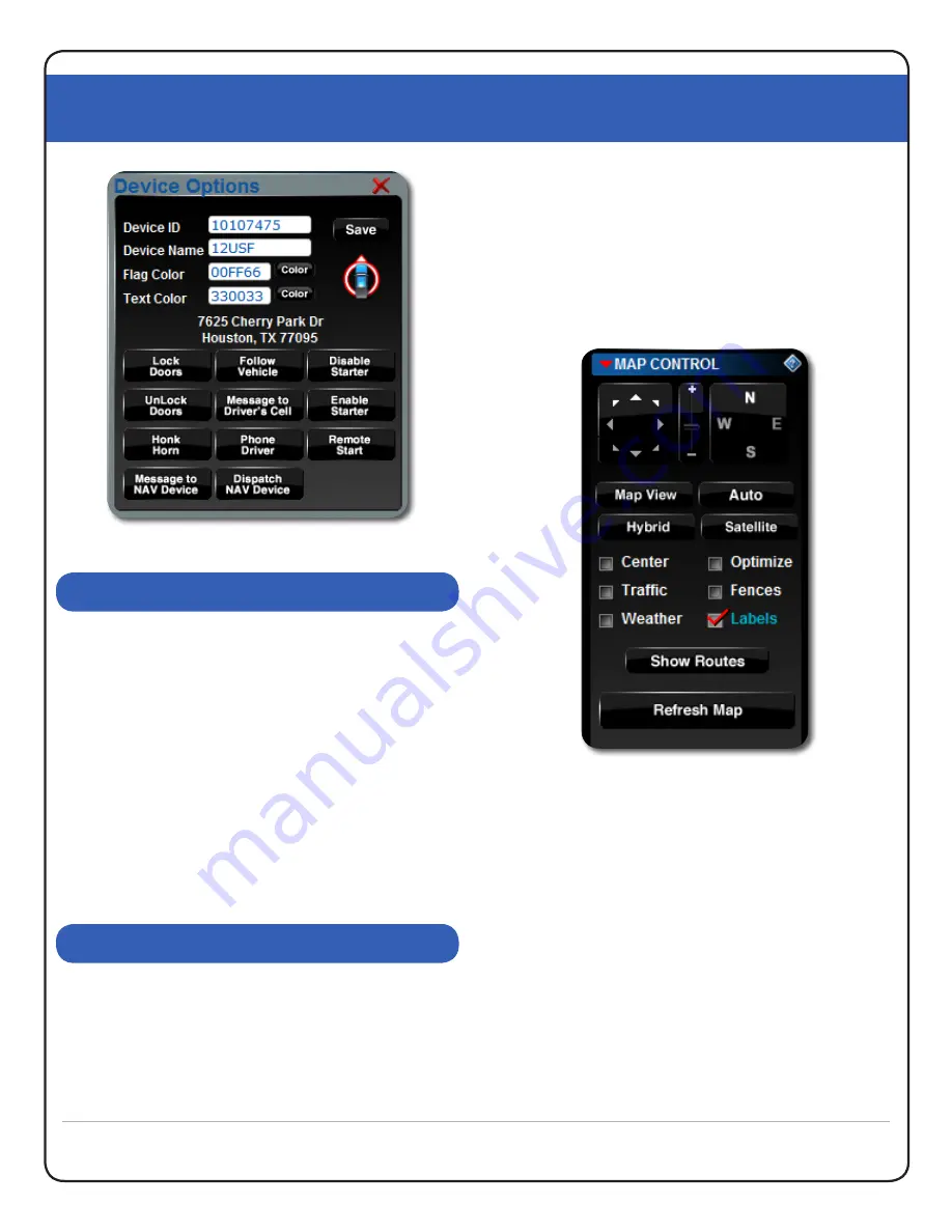
You may select the “Map Control” tab from the control 
panel to the left, and the map control panel will open, 
providing controls to zoom, pan, and set map rendering 
options. The XtremeTrakGPS system relies on Microsoft 
Virtual Earth Maps to provide mapping of the coverage 

area. In larger metro areas, high-resolution aerial images 
(also known as Bird’s Eye images) are available; in more 
rural areas, even Hybrid view may not provide the same 
level of detail as larger metro areas.

If you live in a rural area, you may find it more useful to 
select “Map View” in lieu of Hybrid or Bird’s Eye view.

When  fully  zoomed,  the  maps  provide  detailed  street-
level information, enabling you to see the precise location 
from which your XT-300 tracking device is transmitting. 
When zoomed out completely, you have a complete view 
of the world. If you have only one device, the “Center 
Map”  checkbox  will  automatically  center  the  map  on 
that unit. If you have multiple devices, “Center Map” will 
position the center of the group of devices at the center 
of the browser. If you select a single vehicle (under the 
vehicles  tab),  the  “Center  Map”  checkbox  will  tell  the 
system  to  center  on  the  selected  vehicle.  “Optimize 
Zoom” will zoom as closely as possible while still keeping 
the device or group of devices on the viewable map at 

MAP CONTROL TAB

CONTROL PANEL

Figure 6.0

 GPS Device Options

Figure 6.1

 Map Control Interface

Summary of Contents for XT-300

Page 1: ......

Page 2: ...XtremeTrakGPS XT 300 User Guide XT 300 USER GUIDE 2...

Page 3: ...vert placement under a vehicle Not surprisingly the XT 300 has garnered rave product reviews in the press GPS Magazine calls it The most accurate easy to use GPS Tracker available It s a testament to...

Page 4: ...sensor enabling the device to power off and conserve power after 120 seconds of no movement The instant the device moves it powers back up reconnects and resumes transmission Using this method the XT...

Page 5: ...or flag text color retrieve the address of the vehicle s current location or auto center follow the vehicle To change the vehicle marker click on the vehicle marker image below the save button A windo...

Page 6: ...In larger metro areas high resolution aerial images also known as Bird s Eye images are available in more rural areas even Hybrid view may not provide the same level of detail as larger metro areas I...

Page 7: ...istorical playback control Specifying a single vehicle to track has implications under a number of different controls Check each section of the manual for the impact of individual vehicle selection on...

Page 8: ...ghlighted zone on the screen You may roll the wheel on the back of the mouse to zoom in or out on the map or click and drag to move the map while the Alert Notification Editor is open An Alert Zone ca...

Page 9: ...ields for SMS text message or e mail notifications depending on the method you prefer and select the option to Save Speed Alert You ll see your alert added to the list box at the left Alerts are easil...

Page 10: ...de and click the Find Street Address button To place the marker on the map click the Add Address button at the lower right corner of the Address Editor window A target icon will appear at the location...

Page 11: ...button has been clicked the vehicle marker will begin reanimating the precise path taken on the date selected The marker will leave a vapor trail over the route taken to enable you to easily view the...

Page 12: ...evice s If you have only one device you will see one row of data flow through the activity panel roughly once every 10 seconds any time the vehicle is moving If the vehicle is not moving no data will...

Page 13: ...ack into the website to reconnect to our server and see current locations of your vehicles I got onto Live Chat Support at 4am and nobody answered Live Chat is staffed from 7am to 7pm Monday through F...

Page 14: ...activity panel doesn t show anything moving What s wrong The activity panel shows the flow of data as it is received from your devices If you have only a single device which is not moving you will se...

Reviews: