NAVTEQ iGo Primo User Manual Download Page 37


37 


Tip! 

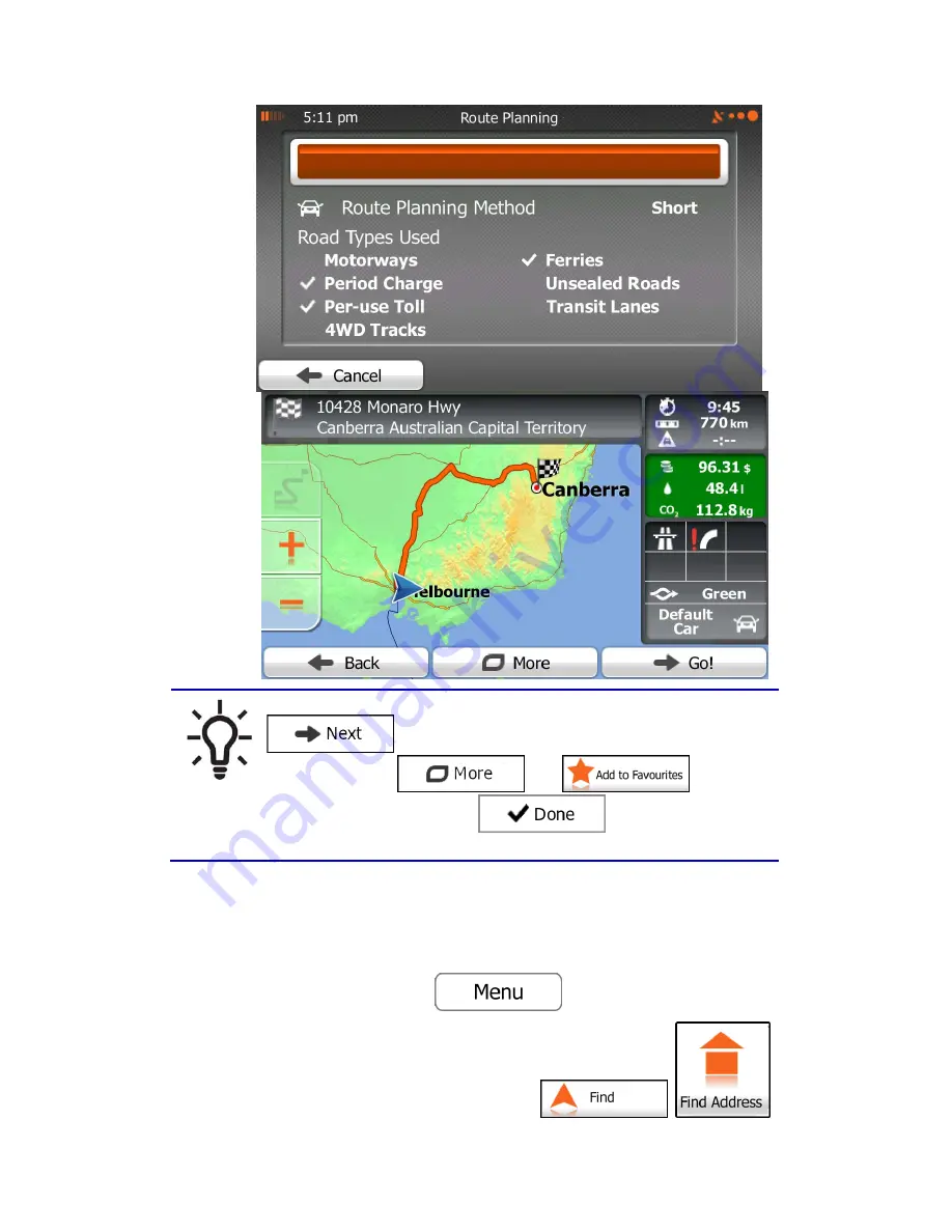
If you know that you will use this destination frequently, before tapping 

 to confirm the destination, put it on the list of your

Favourites first: tap 

 then 

, give a name 

for the new Favourite, and tap 

 to save the location. The 

map with the destination returns automatically. Now you can start your journey.

3.1.1.2 Entering an address starting with the street name 

You can leave the city/town name empty and start the search with the street name. This way 
you can search in all streets of a state. Do as follows: 

1. 

If you are on the Map screen, tap 

 to return to the Navigation menu. 

2. 

In the Navigation menu, tap the following buttons: 

Summary of Contents for iGo Primo

Page 1: ...iGo Primo User Manual OE units Media Replacement Navigation software for car vision UK FlyAudio UK UK English December 2012 ver 1 2a ...

Page 2: ... and start using your unit media aftermerket right away This document is the detailed description of the navigation software You can easily discover your features units while you are using it however we still recommend that you read this manual to fully understand the screens and features ...

Page 3: ...re Am I 29 3 On road navigation 32 3 1 Selecting the destination of a route 32 3 1 1 Entering an address or a part of the address 32 3 1 1 1 Entering an address 33 3 1 1 2 Entering an address starting with the street name 37 3 1 1 3 Entering the midpoint of a street as the destination 41 3 1 1 4 Selecting an intersection as the destination 44 3 1 1 5 Selecting a city town centre as the destination...

Page 4: ...n existing route 94 3 4 8 Changing the vehicle used in route planning 96 3 4 9 Changing the road types used in route planning 97 3 5 Saving a location as a Favourite destination 98 3 6 Saving a location as an alert point 99 3 7 Editing an alert point 100 3 8 Watching the simulation of the route 101 4 Off road navigation 104 4 1 Selecting the destination of the route 104 4 2 Navigating in off road ...

Page 5: ...al guidance settings 125 5 3 6 Display settings 126 5 3 7 Regional settings 126 5 3 8 Trip monitor settings 127 5 3 9 Log collection settings 127 6 Glossary 128 7 End User Licence Agreement 130 8 Copyright note 134 ...

Page 6: ...one will be able to track any personal information If you change your mind later you can enable or disable the log collection in Settings page 127 It is important that you look at the display only when it is safe to do so If you are the driver of the vehicle we recommend that you operate your unit media before you start your journey Plan the route before your departure and stop if you need to chan...

Page 7: ... the first time an initial setup process starts automatically Do as follows 1 Select the written language of the application interface Later you can change it in Regional settings page 126 2 Read the End User Licence Agreement Tap to continue 3 The Configuration wizard starts Tap to continue 4 Select the language and speaker used for voice guidance messages Later you can change it in Sound and War...

Page 8: ...an change them in Regional settings page 126 6 If needed modify the default route planning options Later you can change them in Route settings page 119 7 The initial setup is now complete The Configuration wizard can be restarted later from the Settings menu page 115 ...

Page 9: ...of Functions from the Navigation menu You have the following options Tap to select your destination by entering an address or selecting a place of interest a location on the map or one of your Favourite destinations You can also look up your recent destinations from the Smart History enter a coordinate or use the location saved in a photo When internet connection is available Google Local Search c...

Page 10: ...our selections and applies the new settings without confirmation as soon as you use the controls Type Example Description How to use it Button Tap it to initiate a function to open a new screen or to set a parameter Tap it once Button with value Some buttons display the current value of a field or setting Tap the button to change the value After the change the new value is shown on the button Tap ...

Page 11: ...ndle to move the slider to its new position Tap the slider where you want the handle to appear the thumb jumps there Virtual keyboard Alphabetic and alphanumeric keyboards to enter text and numbers Each key is a touch screen button 2 2 1 Using keyboards You only need to enter letters or numbers when you cannot avoid it You can type with your fingertips on the full screen keyboards and you can swit...

Page 12: ... symbols Tap to switch to a keyboard offering numeric and symbol characters Finalising the keyboard entry accepting the suggested search result Tap Finalising the keyboard entry opening the list of search results Tap Finalising the keyboard entry saving your input Tap Cancelling the keyboard entry returning to the previous screen Tap 2 2 2 Beyond single screen tap You usually need to tap the scree...

Page 13: ...l pages continuously Gestures drag drop You need to drag and drop the screen only in cases like Moving the handle on a slider Scrolling the list grab the list anywhere and slide your finger up or down Depending on the speed of the sliding the list will scroll fast or slow only a bit or till the end Moving the map in map browsing mode grab the map and move it in the desired direction 2 3 Map screen...

Page 14: ...you see the closer you are to get the valid GPS position When GPS position is available the Vehimarker is displayed in full colour now showing your current position If the as If Antenna GPS the relocating try first fix perminent a obtaining GPS the with problems experiencing are you signal GPS the reduce will plastics harder or metal condenced however plastics through see will it dash the under pl...

Page 15: ...default only one data field is displayed in the bottom right corner Tap this field to see all route data fields Tap any of the data fields to suppress others and display only the selected one The data fields are different when you are navigating an active route and when you have no specified destination the orange line is not displayed ...

Page 16: ... whenever such information exists The calculation cannot take into account traffic jams and other possible delays Historical traffic data can be taken into account if data is available Shows the estimated arrival time at the final destination of the route based on information available for the remaining segments of the route Historical traffic data or traffic patterns are also taken into account w...

Page 17: ...played with a radiating red dot to make it visible at all zoom levels The location of the Cursor can be used as the destination of the route a new alert point you can search for Places around it or you can save this location as one of your Favourite destinations You can also select some of the objects on the map If you tap the map at the icon of a Place of Interest or an alert point the object wil...

Page 18: ...next manoeuvre Both the type of the event turn roundabout exiting motorway etc and its distance from the current position are displayed A smaller icon shows the type of the second next manoeuvre if it is near the first one Otherwise only the next manoeuvre is displayed Most of these icons are very intuitive The following table lists some of the frequently shown route events The same symbols are us...

Page 19: ...posts When navigating on multilane roads it is important to take the appropriate lane in order to follow the recommended route If lane information is available in the map data Your system Navigation displays the lanes and their directions using small arrows at the bottom of the map Highlighted arrows represent the lanes you need to take Where additional information is available signposts substitut...

Page 20: ...sts look similar when cruising when there is no recommended route When navigating a route only the signpost that points to the lane s to be taken is displayed in vivid colours all others are darker If you want to hide the currently displayed signposts tap any of them and the normal Map screen returns until new signpost information is received ...

Page 21: ...ows Signposts can also be present if information is available If you want to hide the currently displayed junction tap the picture and the Map screen returns 2 3 3 5 Motorway exit services You may need a petrol station or a restaurant during your journey This feature displays a new button on the map when you are driving on motorways Tap this button to open a panel with the details of the next few ...

Page 22: ... in 2D and use it to plot the route map in 3D when you navigate Hills and mountains are shown in the background of the 3D map and illustrated by colour and shading on the 2D map Elevated roads Complex intersections and vertically isolated roads such as overpasses or bridges are displayed in 3D 3D landmarks Landmarks are 3D artistic or block representations of prominent or well known objects 3D bui...

Page 23: ...known position as the start point Waypoint intermediate destination An intermediate destination of the route before reaching the final destination Destination end point The final destination of the route Route colour The route always stands out with its colour on the map both in daytime and in night colour mode Streets and roads that are excluded from the navigation You can choose whether you want...

Page 24: ...he map is displayed on the screen Your software uses high quality vector maps that let you examine the map at various zoom levels always with optimised content It always displays street names and other text with the same font size never upside down and you only see the streets and objects that you need Map scaling has a limit in 3D map view mode If you zoom out further the map switches to 2D view ...

Page 25: ...on Compass in 3D map view mode The direction of the compass shows North Tap the button to switch to North up view and then tap again to rotate the map in the previous direction Location information Tap this button to open a new screen with information about the selected map point the Cursor Return to normal navigation Tap this button to move the map back to follow the current GPS position Automati...

Page 26: ...at are frequently needed during navigation It can be opened directly from the Map screen by tapping The menu will close after a few seconds of inactivity or if you tap The menu will also close if you initiate simple controls like muting the device In other cases tapping a button will open a new screen with options Most of these functions are shortcuts They are accessible from the menu system ...

Page 27: ...nable sounds More Settings Sound and Warnings Volume Master switch This function lets you search for a Place along your route or around your current location if there is no route calculated Find Find Places Quick Search page 56 This button opens the list of your Favourite destinations Find Favourite page 75 This button opens the History list You can select one of your previous destinations Find Hi...

Page 28: ... the next waypoint from the route n a This button opens a 2D map scaled and positioned to show the entire route My Route Overview page 85 This button opens the Visual Guidance settings screen More Settings Visual Guidance page 125 This button lets you bypass parts of the recommended route My Route Avoidances This button opens the Trip Monitor screen where you can manage your previously saved trip ...

Page 29: ...imulate Navigation page 101 This button starts the Music player application More Music Player page 113 This button opens the GPS Information screen with satellite position and signal strength information Tap the top of the Map screen when there is no GPS reception This button opens the parameters of the selected Vehicle profile More Settings Route page 119 2 3 6 Checking the details of the current...

Page 30: ...tude elevation information coming from the GPS receiver often inaccurate House number on the left House number on the right In the middle of the screen you can see whether the position is current or the time left since it was last updated Address details when available of the current position are also displayed at the bottom You can also perform some actions on this screen Tap to save the current ...

Page 31: ...rched around the current position or the last known position Car repair and roadside assistance services Medical and emergency services Police stations Petrol stations Tap any of the buttons select a Place from the list and navigate to it ...

Page 32: ...stination of a route The software Primo offers you several ways of choosing your destination Enter a full address or a part of an address for example a street name without a house number or the names of two intersecting streets page 32 Enter an address with postal code page 50 This way you do not need to select the name of the settlement and the search for street names might be faster as well Use ...

Page 33: ...te you can search for a city town in all its states 4 Select a new city town a Tap The city town of your current location is offered by default For a local search tap to accept it otherwise continue with entering the destination city town name b Start entering the name of the city town on the keyboard c Find the city town you need The most likely city town name is always shown in the input field T...

Page 34: ... need The most likely street name is always shown in the input field To accept it tap If the desired name does not show up the names that match the string appear in a list after entering a couple of characters to open the list of results before it appears automatically tap Select the street from the list ...

Page 35: ...ouse number a Tap b Enter the house number on the keyboard To enter letters tap c Tap to finish entering the address If the entered house number cannot be found the midpoint of the street is selected as the destination ...

Page 36: ...fy the destination The Cursor appears at the new location Tap to confirm the destination or tap to select a different destination 8 After a short summary of the route parameters the map appears showing the entire route The route is automatically calculated Tap to modify route parameters or tap and start your journey ...

Page 37: ...e location The map with the destination returns automatically Now you can start your journey 3 1 1 2 Entering an address starting with the street name You can leave the city town name empty and start the search with the street name This way you can search in all streets of a state Do as follows 1 If you are on the Map screen tap to return to the Navigation menu 2 In the Navigation menu tap the fol...

Page 38: ...elect the country without a state this function cannot work 4 Enter the street name a Tap b Start entering the street name on the keyboard c Find the street you need The most likely street name is always shown in the input field To accept it tap If the desired name does not show up the names that match the string appear in a list after entering a couple of characters to open the list of results be...

Page 39: ...ouse number a Tap b Enter the house number on the keyboard To enter letters tap c Tap to finish entering the address If the entered house number cannot be found the midpoint of the street is selected as the destination ...

Page 40: ...fy the destination The Cursor appears at the new location Tap to confirm the destination or tap to select a different destination 7 After a short summary of the route parameters the map appears showing the entire route The route is automatically calculated Tap to modify route parameters or tap and start your journey ...

Page 41: ...e number is not available 1 If you are on the Map screen tap to return to the Navigation menu 2 In the Navigation menu tap the following buttons 3 Select the country state and settlement as described earlier page 33 4 Enter the street name a Tap b Start entering the street name on the keyboard c Find the street you need ...

Page 42: ...e does not show up the names that match the string appear in a list after entering a couple of characters to open the list of results before it appears automatically tap Select the street from the list 5 Instead of entering the house number tap The midpoint of the street is selected as the destination ...

Page 43: ...fy the destination The Cursor appears at the new location Tap to confirm the destination or tap to select a different destination 7 After a short summary of the route parameters the map appears showing the entire route The route is automatically calculated Tap to modify route parameters or tap and start your journey ...

Page 44: ...follows 1 If you are on the Map screen tap to return to the Navigation menu 2 In the Navigation menu tap the following buttons 3 Select the country state and settlement as described earlier page 33 4 Enter the street name a Tap b Start entering the street name on the keyboard c Find the street you need ...

Page 45: ...ore it appears automatically tap Select the street from the list 5 Enter the intersecting street name 1 Tap If only a few intersecting streets exist their list appears immediately In case of a longer street the keyboard screen appears Start entering the name of the intersecting street on the keyboard As soon as the street names that match the entered string can be shown on one screen their list ap...

Page 46: ...fy the destination The Cursor appears at the new location Tap to confirm the destination or tap to select a different destination 7 After a short summary of the route parameters the map appears showing the entire route The route is automatically calculated Tap to modify route parameters or tap and start your journey ...

Page 47: ... usually the most important intersection in larger cities it is one of the important intersections 1 If you are on the Map screen tap to return to the Navigation menu 2 In the Navigation menu tap the following buttons 3 Select the country and state as described earlier page 33 4 Select the destination city town a Tap b Start entering the name of the city town on the keyboard c Find the city town y...

Page 48: ...how up the names that match the string appear in a list after entering a couple of characters to open the list of results before it appears automatically tap Select the city town from the list 5 Instead of entering the street name tap This way the centre of the displayed city town becomes the destination of the route ...

Page 49: ...fy the destination The Cursor appears at the new location Tap to confirm the destination or tap to select a different destination 7 After a short summary of the route parameters the map appears showing the entire route The route is automatically calculated Tap to modify route parameters or tap and start your journey ...

Page 50: ...the settlement name Find below an example with a full address 1 If you are on the Map screen tap to return to the Navigation menu 2 In the Navigation menu tap the following buttons 3 Select the country and state as described earlier page 33 4 Enter a new city town using its postal code a Tap b Tap to open the numeric keypad c Start entering the postal code ...

Page 51: ... by tapping Select the postal code from the list 5 Enter the street name a Tap b Start entering the street name on the keyboard c Find the street you need The most likely street name is always shown in the input field To accept it tap If the desired name does not show up the names that match the string appear in a list after entering a couple of characters to open the list of ...

Page 52: ...the street from the list 6 Enter the house number a Tap b Enter the house number on the keyboard To enter letters tap c Tap to finish entering the address If the entered house number cannot be found the midpoint of the street is selected as the destination ...

Page 53: ...fy the destination The Cursor appears at the new location Tap to confirm the destination or tap to select a different destination 8 After a short summary of the route parameters the map appears showing the entire route The route is automatically calculated Tap to modify route parameters or tap and start your journey ...

Page 54: ...54 ...

Page 55: ...rd appears in several names for example in the name of streets roads and avenues you can obtain the result faster if you enter the first letter of the street type For example enter PI A to obtain Pine Avenue and skip all Pine Streets and Pickwick Roads You can also search in postal codes As postal codes consist of only a few characters this is usually faster than entering the name of the city town...

Page 56: ...earch is always carried out along the recommended route if it exists or around your current location if there is no destination given 1 Start the Quick search function If you are on the Map screen tap and then tap If you are in the Navigation menu tap and then tap 2 Using the keyboard start entering the name of the Place ...

Page 57: ...st items A full screen map appears with the selected point in the middle The name and address of the Place is displayed at the top of the screen 6 optional Tap to see the details of the selected Place Tap to return to the map 7 If necessary tap the map somewhere else to modify the destination The Cursor appears at the new location Tap to confirm the destination or tap to select a different destina...

Page 58: ...erest using preset categories The Preset search feature lets you quickly find the most frequently selected types of Places 1 If you are on the Map screen tap to return to the Navigation menu 2 In the Navigation menu tap the following buttons ...

Page 59: ...ccommodation is searched around the destination of the route If there is no active route destination is not selected they are searched around the current position If the current position is not available either no GPS signal they are searched around the last known position If an active route exists restaurants are searched along the route If there is no active route destination is not selected the...

Page 60: ...of the necessary detour If you need to reorder the list tap 6 Browse the list if necessary and tap one of the list items A full screen map appears with the selected point in the middle The name and address of the Place is displayed at the top of the screen 7 optional Tap to see the details of the selected Place Tap to return to the map 8 If necessary tap the map somewhere else to modify the destin...

Page 61: ... can search for Places of Interest by their categories and subcategories 1 If you are on the Map screen tap to return to the Navigation menu 2 In the Navigation menu tap the following buttons 3 Tap 4 Select the area around which the Place should be searched for ...

Page 62: ... city town Tap to search for a place around the destination of the active route The result list will be ordered by the distance from the destination Tap to search along the active route and not around a given point This is useful when you search for a later stopover that results in a minimal detour only such as searching for upcoming petrol stations or restaurants The result list will be ordered b...

Page 63: ... one of the Place subcategories e g Hotel or Motel or tap to list all Places in the selected main category around the selected location or along the route 8 Sometimes the list of brands in the selected Place subcategory appears Select one brand or tap to list all Places in the selected subcategory around the selected location or along the route ...

Page 64: ...from the destination or by the length of the necessary detour If you need to reorder the list tap 11 Browse the list if necessary and tap one of the list items A full screen map appears with the selected point in the middle The name and address of the Place is displayed at the top of the screen 12 optional Tap to see the details of the selected Place Tap to return to the map ...

Page 65: ...p appears showing the entire route The route is automatically calculated Tap to modify route parameters or tap and start your journey 3 1 2 4 Searching for a Place of Interest by name You can search for Places of Interest by their names You can search around different locations or along your route in the whole Place database or in one Place category or subcategory only 1 If you are on the Map scre...

Page 66: ...ll be ordered by the distance from the centre of the selected city town Tap to search for a place around the destination of the active route The result list will be ordered by the distance from the destination Tap to search along the active route and not around a given point This is useful when you search for a later stopover that results in a minimal detour only such as searching for upcoming pet...

Page 67: ...e of the main Place categories e g Accommodation to search in or tap to search among all Places 7 Select one of the Place subcategories e g Hotel or Motel to search in or tap to search in the selected Place category ...

Page 68: ...ap if you have not done it before 9 Using the keyboard start entering the name of the Place 10 After entering a few letters tap to open the list of Places with names containing the entered character sequence ...

Page 69: ...point in the middle The name and address of the Place is displayed at the top of the screen 13 optional Tap to see the details of the selected Place Tap to return to the map 14 If necessary tap the map somewhere else to modify the destination The Cursor appears at the new location Tap to confirm the destination or tap to select a different destination 15 After a short summary of the route paramete...

Page 70: ...70 3 1 2 5 Selecting nearby assistance from Where Am I You can quickly search for nearby assistance from the Where Am I screen 1 On the Map screen tap to open the Quick menu ...

Page 71: ...ch categories appear all for searching around the current position or around the last known position if the current position is not available Car repair and roadside assistance services Medical and emergency services Police stations ...

Page 72: ...items A full screen map appears with the selected point in the middle The name and address of the Place is displayed at the top of the screen 7 optional Tap to see the details of the selected Place Tap to return to the map 8 If necessary tap the map somewhere else to modify the destination The Cursor appears at the new location Tap to confirm the destination or tap to select a different destinatio...

Page 73: ... map location as the destination 1 If you are on the Map screen tap to return to the Navigation menu 2 In the Navigation menu tap the following buttons 3 Locate your destination on the map move and scale the map as needed ...

Page 74: ...ination The Cursor appears 5 Tap to select the Cursor as the destination 6 After a short summary of the route parameters the map appears showing the entire route The route is automatically calculated Tap to modify route parameters or tap and start your journey ...

Page 75: ...tes You can select a location that you have already saved as a Favourite to be your destination Adding a location to the list of Favourite destinations is described on page 98 1 Access the list of Favourites If you are on the Map screen tap and then tap ...

Page 76: ... of the Favourite destination 4 A full screen map appears with the selected point in the middle If necessary tap the map somewhere else to modify the destination The Cursor appears at the new location Tap to confirm the destination or tap to select a different destination 5 After a short summary of the route parameters the map appears showing the entire route The route is automatically calculated ...

Page 77: ... in the Destination menu for easy access Smart History offers these locations based on your navigation habits using parameters like the current time of day the day of week and the current location The more you use the navigation software the better it can guess your desired destination 1 If you are on the Map screen tap to return to the Navigation menu 2 In the Navigation menu tap ...

Page 78: ...ap somewhere else to modify the destination The Cursor appears at the new location Tap to confirm the destination or tap to select a different destination 5 After a short summary of the route parameters the map appears showing the entire route The route is automatically calculated Tap to modify route parameters or tap and start your journey ...

Page 79: ...79 3 1 6 Selecting a recent destination from the History The destinations that you have set earlier appear in the History 1 Access the History If you are on the Map screen tap and then tap ...

Page 80: ...ecent destinations appears Smart History promotes three destinations to the first page based on your previous routes most likely destinations The rest of the destinations are ordered by time they were last selected If necessary scroll the list to see earlier destinations ...

Page 81: ...e new location Tap to confirm the destination or tap to select a different destination 5 After a short summary of the route parameters the map appears showing the entire route The route is automatically calculated Tap to modify route parameters or tap and start your journey 3 1 7 Entering the coordinate of the destination You can also select a destination by entering its coordinate Do as follows ...

Page 82: ...alues in any of the following formats decimal degrees degrees and decimal minutes or degrees minutes and decimal seconds 5 optional If necessary tap then and enter the coordinate in UTM format 6 When finished tap 7 A full screen map appears with the selected point in the middle If necessary tap the map somewhere else to modify the destination The Cursor appears at the ...

Page 83: ...g the entire route The route is automatically calculated Tap to modify route parameters or tap and start your journey 3 1 8 Building a route from the list of destinations Create Route You can also build your route destination by destination from the My Route menu 1 If you are on the Map screen tap to return to the Navigation menu 2 In the Navigation menu tap ...

Page 84: ...t point of the route normally the current GPS position 5 Tap to select the destination 6 The Destination menu appears and you can select the destination of the route the same way as described in the previous sections 7 When the new destination is selected the list returns ...

Page 85: ...e 3 2 Viewing the entire route on the map It is easy to get a map overview of the active route Do as follows 1 If you are on the Map screen tap to return to the Navigation menu 2 In the Navigation menu tap 3 Tap The active route is displayed in its full length on the map together with additional information and controls ...

Page 86: ...te e g unpaved roads or toll roads to be taken The total time of the route The total length of the route Estimated delay calculated from traffic events on your route The symbol of the vehicle type used in route calculation The route planning method e g Fast 4 You have the following options on this screen for detailed instructions on how to use them see the next chapter Tap to edit the route to add...

Page 87: ...dify the active route The following sections show some of those options 3 4 1 Selecting a new destination when already having a route New Route Waypoint or Final Destination If you already have a recommended route and you select a new destination as described in the above sections the application will ask you whether to start a new route add a new waypoint intermediate destination to the route or ...

Page 88: ... remain intact The previous final destination is now the last waypoint 3 4 2 Setting a new starting position for the route For normal navigation all routes are planned from the current position In order to check future routes simulate them or see their length in time and distance you can turn off the GPS receiver Then you can set the starting point of the route to a different location than the cur...

Page 89: ...the start of the route normally the current GPS position Tap and confirm your action at the warning message 5 The Destination menu appears and you can select the start point of the route the same way you select a destination ...

Page 90: ...alculated starting from the selected location 8 To return to normal navigation tap 3 4 3 Editing the list of destinations Edit Route You can edit the route by modifying the list of destinations You can add or remove destinations modify the start position or reorder the list 1 If you are on the Map screen tap to return to the Navigation menu 2 In the Navigation menu tap 3 Tap ...

Page 91: ...y the start point of the route Tap to reorder the list You can do it manually or you can let the application optimise the route for you 3 4 4 Pausing the active route You do not need to pause the active route when you start driving again Your system media restarts the voice instructions from your position ...

Page 92: ...aypoints are deleted In the Navigation menu tap and then tap The active route is deleted with all its waypoints 3 4 6 Checking route alternatives when planning the route You can select from different route alternatives or change the route planning method after you have selected a new destination Do as follows 1 Select a destination as explained earlier and get to the route confirmation screen 2 Ta...

Page 93: ... basic details of three route alternatives with the selected route planning method Tap any of them to see it on the map 5 Or if you cannot find a good alternative tap and scroll down for routes with different routing methods ...

Page 94: ...king route alternatives for an existing route To recalculate the active route with a different route planning method you can modify the Route settings page 119 There is another way to do this and to compare different route alternatives with the same route planning method Do as follows 1 If you are on the Map screen tap to return to the Navigation menu 2 In the Navigation menu tap 3 Tap ...

Page 95: ... basic details of three route alternatives with the selected route planning method Tap any of them to see it on the map 6 Or if you cannot find a good alternative tap and scroll down for routes with different routing methods ...

Page 96: ... location for a few seconds to return to the Map screen Your system media recalculates the route The orange line now shows the new recommended route 3 4 8 Changing the vehicle used in route planning To recalculate the active route for a different vehicle do as follows These changes can also be made in Settings page 119 1 On the Map screen tap and then tap 2 Tap and then tap one of the following ...

Page 97: ...back to a vehicle later the software warns you when you travel with a speed that is too high for a pedestrian You are allowed to switch back instantly to 3 4 9 Changing the road types used in route planning To recalculate the active route with different road type preferences do as follows These changes can also be made in Settings page 119 1 On the Map screen tap and then tap ...

Page 98: ...he accessibility of temporary ferries You might also need to pay a fare on ferries Your system media excludes unpaved roads by default unpaved roads can be in a bad condition and usually you cannot reach the speed limit on them 4WD tracks are dirt roads in very poor condition They can only be driven by 4WD vehicles Your system media excludes 4WD tracks by default 3 Tap to confirm the changes Your ...

Page 99: ...o enter numbers or symbols 5 Tap to save the location as a new Favourite destination 3 6 Saving a location as an alert point You can save any map location as an alert point for example a speed camera or a railway crossing 1 Browse the map and select a location The red Cursor appears there 2 Tap ...

Page 100: ...ert and if applicable the speed limit for this alert point 5 Tap to save the location as a new alert point 3 7 Editing an alert point You can edit a previously saved or uploaded alert point for example a speed camera or a railway crossing 1 Browse the map and select the alert point to edit The red circle appears around the alert point 2 Tap ...

Page 101: ...ct the alert or if applicable the speed limit for this alert point 5 Tap to save the changes to the alert point 3 8 Watching the simulation of the route You can run a simulated navigation that demonstrates the active route Do as follows 1 If you are on the Map screen tap to return to the Navigation menu 2 In the Navigation menu tap ...

Page 102: ...102 3 Tap 4 Scroll down the list and tap The simulation starts from the starting point of the route and using a realistic speed it leads you through the whole recommended route ...

Page 103: ...a few seconds but you can open them again if you tap the map Jump to the next route event manoeuvre Pause the simulation Jump to the previous route event manoeuvre Tap to increase the speed of the simulation to 4 8 or 16 times faster Now tap again to return to the normal speed 2 Tap to stop the simulation ...

Page 104: ...ting the destination of the route Selecting the start point or a destination waypoint or final destination is the same as described at on road navigation The only difference is that route points are linked to form a route with straight lines regardless of the road network and traffic regulations 4 2 Navigating in off road mode The real difference between the on road and off road modes is the navig...

Page 105: ...05 When you reach a waypoint the light blue line will show the direction to the next destination Future legs of the route are shown with orange lines When you reach the final destination navigation ends ...

Page 106: ... screens Daytime colours are similar to paper road maps and the menus are bright The night colour themes use dark colours for large objects to keep the average brightness of the screen low HEMA NAVIGATOR offers different daytime and night colour profiles It can also switch automatically between the daytime and the night schemes based on the current time and GPS position a few minutes before sunris...

Page 107: ...directional constraints are taken into account when planning a route Roads are used only if access for pedestrians is allowed Controlled access roads are excluded from routes A private road is used only if the destination is there Speed limits are not used in route calculation and an average walking speed is used when calculating the estimated time of arrival Manoeuvre restrictions and directional...

Page 108: ... the proposed itinerary For further information about Route settings see page 119 5 1 4 Green routing Route calculation is not only about finding the quickest or shortest route For some of the vehicle types you can also check the fuel consumption and CO2 emission when planning a route and you can create cost effective routes with less effect on the environment In Route settings you can edit the pa...

Page 109: ...screen Tap the field with these details to switch the route to Green immediately 5 1 5 Road safety cameras and other proximity alert points There is a special proximity warning for road safety cameras like speed or red light cameras and other proximity alert points like schools or railroad crossings These alert points are preloaded in HEMA NAVIGATOR You can download more from www naviextras com or...

Page 110: ...pear on the Map screen while you are approaching one of these cameras The distance from the camera is also displayed For some of the alert points the enforced or expected speed limit is available For these points the audio alert can be different if you are below or above the given speed limit Only when speeding The audio alert is only played when you exceed the given speed limit When approaching T...

Page 111: ...he application initiates the warning The following alert types are available Audio warning you receive a verbal warning when you exceed the speed limit with the given percentage Visual warning the current speed limit is shown on the map when you exceed it for example You can also choose to see the speed limit sign on the map all the time 5 1 7 Battery and GPS position quality indicators You can fi...

Page 112: ...3D position GPS navigation is possible 5 1 8 Stored and real time traffic information in route planning The recommended route is not always the same between two points Offline statistical traffic information historical speed information or traffic patterns can be taken into account in the route calculation based on the time of day and the day of week whenever suitable data exists In addition real ...

Page 113: ...e 1 You can display statistical traffic information on the map if you browse the map and select this option from the More menu 5 2 More menu The More menu provides you with various options and additional applications Tap the following buttons Button Description You can configure the program settings and modify the behaviour of HEMA NAVIGATOR Fine tune route planning options change the look of the ...

Page 114: ...ption monitor helps you keep track of the consumption of your car even if you do not use navigation for all your journeys Set the initial odometer value and then record the distance taken and fuel filled in whenever you fill your car You can also set reminders for regular car maintenance Tap this button to see the sunlit and dark areas of the world Your current location and route points are marked...

Page 115: ... media Tap the following buttons The Settings menu has several options Tap or scroll with your finger to see the full list Button Description Adjust the sound volume mute your device or change the voice guidance language In addition you can enable and set up different warnings and alerts The content of the Quick menu page 26 is fully customisable Tap the button you want to change and select its ne...

Page 116: ...ut your trips Trip logs can be saved manually when you reach your destination or you can turn on the automatic saving here The application collects usage information and GPS logs that may be used for improving the application and the quality and coverage of maps Here you can enable or disable collecting these logs Modify the basic software parameters set during the initial setup process For detail...

Page 117: ...ou wish to receive visible and or audible warnings Adjust the slider to set the relative speed above which the application initiates the warning The following alert types are available Audio warning you receive a verbal warning when you exceed the speed limit with the given percentage Visual warning the current speed limit is shown on the map when you exceed it If you prefer to see the speed limit...

Page 118: ...ints the audio alert can be different if you are below or above the given speed limit Only when speeding The audio alert is only played when you exceed the given speed limit When approaching The audio alert is always played In order to draw your attention the alert can be different if you exceed the speed limit Maps may contain driver alert information Tap this button to turn on or off these warni...

Page 119: ... road network on the map Switch to off road navigation to navigate between destinations in a straight line The route calculation can be optimised for different situations and vehicle types by changing the planning method See below for details If the selected routing method is not Green you can have your route compared to the best green alternative on the screen when confirming the route If this al...

Page 120: ...pay a fare on ferries Your system media excludes unpaved roads by default unpaved roads can be in a bad condition and usually you cannot reach the speed limit on them 4WD tracks are dirt roads in very poor condition They can only be driven by 4WD vehicles Your system media excludes 4WD tracks by default Vehicle profiles When you first tap you see the list of default vehicle profiles You have the f...

Page 121: ...cost calculation The currency can be set in Regional Settings Set the maximum speed you travel with the vehicle Check this box to enable more settings for the below parameters Set the total length of the vehicle Set the width of the vehicle Set the height of the vehicle Set if there is a trailer attached to the vehicle Set the maximum allowed weight of the vehicle Set the actual weight of the vehi...

Page 122: ...applied to bicycles in the map data are taken into account when planning a route Roads are used only if access for bicycles or pedestrians is allowed Controlled access roads are excluded from routes A private road is used only if the destination is there Speed limits are not used in route calculation and an average cycling speed is used when calculating the estimated time of arrival All manoeuvres...

Page 123: ...123 Roads are used only if access for taxis is allowed Private roads resident only roads and walkways are excluded from routes ...

Page 124: ...ations are estimations only They cannot take elevations curves and traffic conditions into account Results in a route with fewer turns and no difficult manoeuvres With this option you can make Your system media to take for example the motorway instead of a series of smaller roads or streets 5 3 4 Map settings You can fine tune the appearance of the Map screen Adjust the map view to your needs choo...

Page 125: ...ther vehicles Show or suppress 3D landmarks 3D artistic or block representations of prominent or well known objects Show or suppress 3D city models 3D artistic or block representation of full city building data containing actual building size and position on the map Turn on or off track log saving that is saving the sequence of the locations your journeys go through Select which Places to show on ...

Page 126: ...he real ones on road signs above the road is displayed at the top of the map You can turn this feature on or off If you are approaching a motorway exit or a complex intersection and the needed information exists the map is replaced with a 3D view of the junction You can turn this feature on or let the map be displayed for the whole route Turn on the route progress bar to see your route as a straig...

Page 127: ...om the More menu Trip monitor can record statistical data of your trips If you need these logs later you can let the application save them automatically for you This is not a button This line shows the current size of the trip database the sum of all trip and track logs saved Track logs the sequence of the positions given by the GPS receiver can be saved together with trip logs They can later be d...

Page 128: ... are custom graphic settings and they can have different colours for streets blocks or surface waters in 2D and 3D modes and they display shades or shadows in different ways in 3D mode One daytime scheme and one night scheme is always selected for the map and for the menus Your system media uses them when it switches from day to night and back GPS accuracy Several factors have impact on the deviat...

Page 129: ...crossings are also available Route A sequence of route events i e manoeuvres for example turns and roundabouts to reach the destination The route contains one start point and one or more destinations The start point is the current or last known position by default If you need to see a future route the start point can be replaced with any other given point Track up map orientation In Track up mode ...

Page 130: ...to as the Software Product 4 2 The Software Product shall include the operating computer program its complete documentation the map database pertaining thereto and any third party content and services accessible through the Software Product hereinafter Database 4 3 Any form of display storage coding including printed electronic or graphic display storage source or object code or any other as yet u...

Page 131: ...using the computer program to obtain information from the Database as a part of the Software Product to decompile the Database to use copy modify extend transform the Database in whole or in part or the group of data stored therein or to install it in other products or otherwise utilise it in other products or to transfer it not even with the aim of achieving interoperability with other products 7...

Page 132: ... may be sentenced of two years in prison in basic cases and up to eight years in prison in aggravated cases 9 3 Contents and services provided by third parties The Licensor hereby excludes any liability of its own for the Database in the Software Product and for any content or service provided by a third party by using the Database The Licensor does not warrant the quality suitability accuracy fit...

Page 133: ...roving the features and services of the Software Product and the Databases Uploading is executed through Licensor s special software or by the User navigation device and the upload may be enabled or disabled by User After successful data upload the collected data is deleted from the Software Product storage media 10 3 Collected data is transmitted stored and handled anonymously and no connection o...

Page 134: ...y not in whole or in part be reproduced or transmitted in any form either electronically or mechanically including photocopying and recording without the express written consent of WISE ICE LTD 2011 WISE ICE LTD Whereis map data is 2006 Telstra Corporation Limited and its licensors 2011 NAVTEQ All rights reserved All rights reserved ...

Reviews: