31
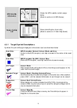
GPS Satellite
Information
Shows the GPS satellite current usage
status
(Refer to section 4.12 GPS Status)
Region Setting
List
Show all the Region of own ship
(Refer to section 4.7.3 Own Ship Detail)
4.2.1 Target Symbol Descriptions
Symbols for each AIS target displayed on the radar view is as described below:
Own Ship
GPS Reception: Normal / Colour: Black and Grey
Under normal GPS reception, own ship is located in the centre of the radar
view.
Own Ship
GPS Reception: No GPS / Colour: Blue
Without GPS reception, own ship needs to be located manually.
AIS Target
Colour: Black
Ship equipped with AIS system in the surrounding sea will appear on the
radar view as an AIS target.
Selected Target
Colour: Black / Flashing Coloured Frame
Use the arrow keys to select any target on the radar view. After selected,
press <ENT> and the detailed information on each target can be viewed.
Dangerous
Target
Colour: Red / Circled Frame
When distance to a ship is smaller than CPA/TCPA, the target will be
circled in RED. Use the arrow keys to select the dangerous target and to
view its detailed information.
Friend Ship
Colour: Magenta
If any pre-stored Friend Ship is nearby, the Friend Ship will appear in
Magenta on the radar view.
Summary of Contents for 21-100-001A
Page 1: ......
Page 2: ...2 ...
Page 3: ...3 Smartfind M5 Class A Inland AIS Installation and Maintenance Manual ...
Page 12: ...12 2 3 Interconnection Diagram Figure 1 Interconnection Diagram ...
Page 81: ...81 6 MECHANICAL DIMENSIONS 6 1 Smartfind M5 Transponder Main Unit Front size mm Side size mm ...
Page 82: ...82 Back size mm Bottom size mm ...
Page 83: ...83 6 2 Junction Box 6 3 Extension Cable 6 4 Mounting Template not to scale 85 mm 55 mm 165 mm ...
Page 84: ...84 6 5 GPS Antenna 6 6 Pilot Plug 2 m 60 mm 40 mm 60 mm 80 mm 103 92 mm ...
Page 112: ...112 Note ...
Page 113: ...113 21 135 001N Issue 15 ...
Page 114: ......


