background image

22

GTN 725/750 Cockpit Reference Guide (CRG)

190-01007-04  Rev. C

Te

rrain

TERRAIN


NOTE:  

Features may vary, depending on your confi guration.


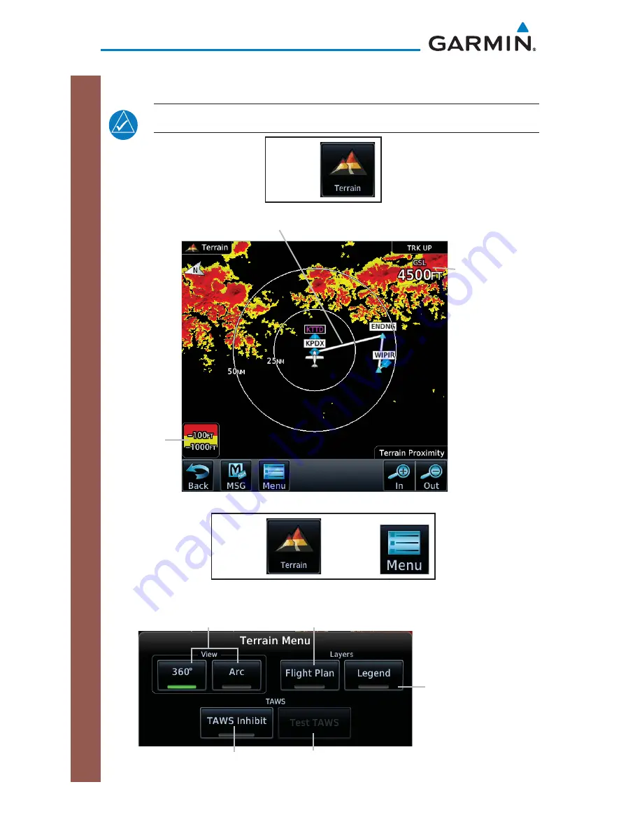
Terrain

Legend

GPS 
Computed 
Altitude

Active Flight Plan

Terrain Page


Terrain Menu

Touch to display the active fl ight plan.

Touch to display terrain 
as 360° ring or 120° arc.

Touch to suppress TAWS alerts.

Touch to display 
the terrain legend.

Touch to test the TAWS.

Terrain Menu Options

Summary of Contents for GTN 725

Page 1: ...Map Traffic Terrain Weather Procedures Charts Waypoint Info Nearest System Services Utilities GTN 725 750 Cockpit Reference Guide CRG Flight Plan ...

Page 2: ...ognize that providing monitoring and or self test capability for all conceivable system failures is not practical Although unlikely it may be possible for erroneous operation to occur without a fault indication shown by the GTN 725 750 It is thus the responsibility of the pilot to detect such an occurrence by means of cross checking with all redundant or correlated information available in the coc...

Page 3: ...nd understand all aspects of the GTN 725 750 Pilot s Guide as well as this guide Thoroughly practice basic operation prior to actual use During flight operations carefully compare indications from the GTN 725 750 to all available navigation sources including the information from other NAVAIDs visual sightings charts etc For safety purposes always resolve any discrepancies before continuing navigat...

Page 4: ...NERS CONTAINING AMMONIA WILL HARM THE ANTI REFLECTIVE COATING It is very important to clean the display using a clean lint free cloth and an eyeglass lens cleaner that is specified as safe for anti reflective coatings CAUTION Garmin would like to remind pilots flying with GDL 69 69A equipped aircraft thatTFRs are only advisory and Garmin would like to remind pilots flying with GDL 69 69A equipped ...

Page 5: ...cer birth defects or reproductive harm This notice is being provided in accordance with California s Proposition 65 If you have any questions or would like additional information please refer to our web site at www garmin com prop65 NOTE Canadian Installations In accordance with Canadian Radio Specifications Standard 102 RSS 102 RF field strength exposure to persons from an antenna connected to th...

Page 6: ...0 Cockpit Reference Guide CRG 190 01007 04 Rev C Record of Revisions Part Number Revision Date Description 190 01007 04 A B C Feb 2011 Mar 2011 Nov 2012 Initial Release Updated message list Added v3 00 functionality ...

Page 7: ...4 Changing NAV Data Fields 15 Changing Data Fields 15 Pan Mode 16 User Waypoints 16 Creating or Editing a Flight Plan in Pan Mode 17 TRAFFIC 18 Traffic System Status Annunciations 19 TCAS System Menu 20 TCAD System Menu 21 TERRAIN 22 WEATHER 23 SiriusXM Weather Optional 23 FIS B Weather 24 Connext Weather Optional 25 Radar Optional 26 CHARTS 28 Chart Information 28 Menu Options 28 FLIGHT PLAN 29 C...

Page 8: ...TILITIES 42 Vertical Calculator VCALC 43 SYSTEM 44 Crossfill 45 SYMBOLS 47 Map Symbols 47 SafeTaxi Symbols 48 Traffic Symbols 48 TIS 48 Terrain Obstacle Symbols 50 Basemap Symbols 51 Map Tool Bar Symbols 51 Miscellaneous Symbols 52 Stormscope Symbols 53 MESSAGES 54 GLOVE QUALIFICATION PROCEDURE 74 Tests Required for Glove Qualification 75 Tests Not Required for Glove Qualification 76 ...

Page 9: ...V Frequency Direct To Key Photo Sensor Home Key SD Card Messages Function Icons Touchscreen Display Large and Small Knob Function Annunciation Locking Screw GTN 750 Front Panel Main Page Direct To Key Press to provide a direct course to a selected waypoint Home Key A single press of the Home Key returns the user to the main page to access features Pressing and holding the HOME key while on any pag...

Page 10: ... with the large and small right knobs or the touch keypad 3 Touch Activate or press the small right knob Text near the small right knob indicates its current function Direct To a Flight Plan Waypoint OR 1 Press Direct To 2 Touch the FPL tab and then the desired Flight Plan waypoint 3 Touch Activate or press the small right knob Direct To a Nearest Airport OR 1 Press Direct To 2 Touch the NRST APT ...

Page 11: ...tate of operation for the related feature The COM or NAV frequency is changed by touching the STBY field and using the keypad to enter the desired frequency Press Enter when finished or Back to exit without making changes If an entry was started touch Cancel to exit out of the screen without making changes COM Standby Page Mon Monitors the standby COM frequency Find Displays categories for User Re...

Page 12: ...kHz value Frequency Flip Flop To flip flop the active and standby NAV COM frequencies press and hold the small knob or touch the active NAV COM frequency field An annunciation Hold for Flip Flop will be displayed near the knobs Audio Panel The audio panel allows you to control the audio equipment of the aircraft A green bar indicates that a particular selection is enabled Touch the Audio Panel key...

Page 13: ...e of the cabin speakers Marker Audio Touch to hear tones for marker beacons Marker Volume Touch to adjust the volume of the marker beacon broadcast Marker Hi Sense Touch to allow detection of the outer marker beacon at a greater distance 3D Audio Touch to toggle the 3D audio function on and off Monitored Radios The Monitor fuction indicates which radios are being listened to by the crew and passen...

Page 14: ...S NAV COM Intercom Intercom Touch to adjust pilot s volume and squelch Touch to adjust co pilot s volume and squelch Touch to adjust passenger s volume and squelch Touch arrow to activate communication between recipients See Intercom Modes table Intercom Setup Page ...

Page 15: ...ot Selected radios co pilot pilot passengers Co pilot passengers Selected radios pilot passengers Selected radios co pilot Pilot passengers Selected radios pilot Selected radios co pilot passengers Co pilot passengers Selected radios pilot co pilot passengers Selected radios pilot co pilot Selected radios pilot passengers Selected radios pilot passengers Selected radios co pilot passengers Selecte...

Page 16: ...M or Split Mode Toggles split COM mode NAV NAV one Toggles NAV1 audio NAV two Toggles NAV2 audio MUSIC MUSIC one mute or Mute MUSICD one Mutes Music 1 on radio reception Disable MUSIC one mute MUSIC one mute disable Disable mute MUSIC one or Mute MUSIC one disable Disables Music 1 mute on radio reception MUSIC two mute or Mute MUSIC two Mutes Music 2 on radio reception Disable MUSIC two mute MUSIC...

Page 17: ...and Up or Down is equivalent to five clicks of the Volume knob Distribution Blue Mode Distribute telephone to desired position s or Distribute phone to desired position s Distributes Telephone to desired positions Distribute music one to desired position s Distributes MUS1 to desired position s Distribute music two to desired position s Distributes MUS2 to desired position s Desired position s All...

Page 18: ...ble modes IDENT Field Squawk Code Field Transponder Modes Standby Ground On Altitude Reporting Transponder Control Transponder ID Touch the Squawk Code Field Enter the code for either XPDR 1 or XPDR 2 using the displayed keypad Touch ENTER to confirm selection IDENT Touch IDENT to activate the transponder s IDENT function The key text remains gray and will change to green when IDENT mode is active...

Page 19: ... transponder in Ground mode Mode S interrogations will be allowed GND displays in the squawk code field On Touch to turn transponder On for Mode A operation Will transmit the squawk code when interrogated ON displays in the squawk code field Altitude Reporting Touch for Mode C operation The transponder will be on and will transmit its squawk code and altitude when interrogated ALT displays in the ...

Page 20: ...in the squawk code field On Touch to turn transponder On for Mode A operation Will transmit the squawk code when interrogated ON displays in the squawk code field Altitude Reporting Touch for Mode C operation The transponder will be on and will transmit its squawk code and altitude when interrogated ALT displays in the squawk code field VFR Touch to set the squawk code to 1200 Anonymous Touch to a...

Page 21: ...hed selecting the new code The table below lists special squawk codes Squawk Code Description 1200 Default VFR code in the USA 7500 Hijacking 7600 Loss of Communications 7700 Emergency Special Squawk Codes NOTE While 1200 is the default VFR squawk code the installer can configure any code to the VFR key This is to support international operations where 1200 may not be used ...

Page 22: ...icates the selection is enabled Touch to select which fields are displayed in four corners on Map page Touch to restore the map page to the original factory settings Touch to customize how the map aviation land and weather information is displayed on the map page Touch hold and slide to set how much detail is shown on the map page Map Menu Options Page ...

Page 23: ...t Waypoint DIS to Dest Distance to Destination DTK Desired Track ESA Enroute Safe Altitude ETA Estimated Time of Arrival ETA at Dest ETA at Destination ETE Estimated Time Enroute ETE to Dest ETE to Destination Fuel Flow Total Fuel Flow Generic Timer Timers Utilities GS GPS Ground Speed GSL GPS Altitude MSA Minimum Safe Altitude OAT static Static Air Temperature OAT total Total Air Temperature Time...

Page 24: ... the information key to display any available information related to that symbol Touch the Next key to cycle to other waypoints close to the cursor User Waypoints Touch any location on the map that is not an existing waypoint to create a user waypoint The Waypoint Info key will display Create Waypoint and will display the Create User Waypoint page See the Waypoint Info Creating User Waypoint secti...

Page 25: ...he current position and a direct to waypoint unless that waypoint is in the flight plan Garmin recommends deleting any flight plan prior to graphically editing a direct to waypoint Edit Flight Plan On the Map page enter Pan Mode by touching the screen Touch the Graphically Edit FPL key Touch any waypoint that you want to be part of your flight plan Should you make an error touch the Undo key The U...

Page 26: ...1007 04 Rev C Traffi c TRAFFIC Traffic NOTE Depending on which traffic device is installed and how it is configured the pages will be different that what is shown Refer to the GTN 725 750 Pilot s Guide P N 190 01007 03 for more information Traffic Page ...

Page 27: ...traffic information is reduced when this message is displayed Traffic Removed Traffic is removed because it is too old for coasting 12 to 60 seconds since last message Traffic may exist within the selected display range but it is not displayed Traffic Status Banner Annunciation Description TA 6 0 03 System cannot determine bearing of Traffic Advisory Annunciation indicates distance in NM altitude ...

Page 28: ...de or standby mode Test The Test key places the traffic system in test mode and also tests the communication between the GTN and the configured traffic device Motion Vector Touch to set the type of motion vector Selections Absolute Relative Off Vector Duration Touch to set the amount of time the motion vector remains Selections 30 sec 1 min 2 min 5 min Altitude Filter Touch to select what traffic ...

Page 29: ... to 2700 ft Normal 2700 ft to 2700 ft Above 2700 ft to 9900 ft Unrestricted All Traffic Shown TCAD System Menu The TCAD Control Menu allows control over the settings for the TCAD Traffic display TCAD Control Menu Touch to set traffic audio volume Touch to activate operation Touch to set local baro Touch to select approach mode Touch to select field elevation Touch to select ground mode TCAD Traffi...

Page 30: ...nding on your configuration Terrain Legend GPS Computed Altitude Active Flight Plan Terrain Page Terrain Menu Touch to display the active flight plan Touch to display terrain as 360 ring or 120 arc Touch to suppress TAWS alerts Touch to display the terrain legend Touch to test the TAWS Terrain Menu Options ...

Page 31: ...e weather system is installed Refer to the GTN 725 750 Pilot s Guide P N 190 01007 03 for more information Weather SiriusXM Weather Menu SiriusXM Weather Optional Touch to display the legend Touch keys to select weather product Green bar indicates selected product Touch NEXRAD key to select Off US or Canada NEXRAD Touch to select the weather overlay map oreientation SiriusXM Weather Menu Options ...

Page 32: ...her FIS B Weather FIS B Weather Menu Touch keys to select weather product Green bar indicates selected product Touch NEXRAD key to select Off US or Canada NEXRAD Touch to display the legend Touch to select the weather overlay map orientation FIS B Weather Menu Options ...

Page 33: ...the display of IR satellite information METAR Touch to toggle the display of METARs PIREP Touch to toggle the display of PIREPs Winds Aloft Touch to toggle the display of Winds Aloft SIGMET AIRMET Touch to toggle the display of SIGMETs AIRMETs Connext Settings Touch to set region of coverage data request and to view the status of the datalink Orientation Touch to display map orientation options No...

Page 34: ...ll features are available on all radar systems Refer to the GTN 725 750 Pilot s Guide P N 190 01007 03 for more information Radar Menu GWX 70 Weather Radar Menu Options Key Description Turbulence Detection Touch to enable turbulence detection GCS Touch to enable ground clutter suppression ACT Touch to enable altitude compensated tilt WATCH Shading Touch to enable WATCH shading Weather Alert Touch ...

Page 35: ...ding Touch to enable WATCH shading Weather Alert Touch to enable weather alerts Stabilize Touch to enable antenna stabilization NOTE Ground Clutter Suppression GCS and Turbulence Detection are only supported for 12 or larger RADAR antennas Turbulence Detection is only supported out to a range of 40 NM and is disabled at display ranges greater than 160 NM ...

Page 36: ... Touch to view departure procedures Touch to display chart in full screen Touch to view arrival procedures Touch to view airport information such as general info preview procedures runways frequencies WX Data and Chart NOTAMs Touch to zoom in or out on chart Charts Page Menu Options Shows an inverted color view of the display that enhances low light viewing Touch to select chart information Select...

Page 37: ...Plan Creating a Flight Plan On the Flight Plan page touch Add Waypoint to display an alphanumeric keypad Type in the airport identifier and touch Enter If unknown touch the Find key to search To exit without making changes to the flight plan touch the Cancel key Keypad Keypad Entry Sample Flight Plan ...

Page 38: ... previously stored flight plans Touch to edit fields shown on flight plan page Touch to reverse currently loaded flight plan Touch to delete current flight plan Flight Plan Menu Page Flight Plan Catalog Touch to activate a flight plan Touch to edit flight plan Touch to delete flight plan Touch to activate and reverse flight plan Touch to review flight plan prior to loading Touch to copy flight pla...

Page 39: ... Waypoint Options menu is displayed Load Airway Touch entry waypoint to select available airways and exit waypoints Load Touch to load selected airway into flight plan Cancel Touch to exit without changes to flight plan Remove Airway Touch to remove airway from flight plan Touch Preview if desired to review selected airways Touch to load selected airway to flight plan Airway Selection for Waypoint...

Page 40: ...s PROCEDURES Procedures Departures Arrivals and Approaches On the Procedures PROC page select approach arrival and departure procedures Touch to Select Available Approach Selection Touch to enter departure Touch to enter approach Touch to enter arrival Procedures PROC Page ...

Page 41: ...ain Suspended key to continue with sequencing suspended or touch Activate GPS Missed Approach for guidance to the Missed Approach Hold Point Flying an Approach with a Hold Upon activating an RNAV GPS approach you are given the option to skip any non required holding patterns during the initial transitions of the approach In a GPS approach you will not be given the option and you must manually rese...

Page 42: ...equency of the nearest VOR Touch to display the bearing distance and frequency of the nearest ARTCC Touch to display the bearing and distance of the nearest airspace along your route Touch to display the bearing distance and frequency of the nearest Flight Service Station Touch to display the bearing distance and frequency of the nearest weather station Touch to display the bearing distance and fr...

Page 43: ...ce bearing and reference waypoint information for created waypoints Touch to display the map of an airport procedures runways frequencies weather and any NOTAMs Touch to display the distance and bearing latitude and longitude location and the nearest VOR Touch to display the distance and bearing latitude and longitude location frequency nearest airport VOR Class and magnetic variation Touch to dis...

Page 44: ...tifier and position or reference another waypoint by radial and distance The identifier can be a maximum of 6 characters and the comment can be a maximum of 24 characters 3 Touch Create to confirm your entry Touch to enter name of waypoint Touch to edit comment Touch to select position type Choices are LAT LON Radial Radial and Radial Distance Reference Waypoint Radial and Distance Touch to confir...

Page 45: ...ntacts Touch to listen to music Touch to activate phone Touch to review position report settings Services Page Phone Phone Status Touch to enter pohne number Touch to place a call Touch to end call Touch to decrease volume Touch to increase volume Touch to select type of suppression Choices are Off On On During APR MAPR TERM Phone Page ...

Page 46: ...r using the keypad Touch Enter 4 Touch the Call key 5 Touch the End Call key when finished SMS Text Touch to compose a text Touch to delete a text Touch to save a draft of text Touch to send a text SMS Text Message Page Sending an SMS Text 1 Touch the SMS Text key to display the SMS text page 2 Touch the To window to select recipient s email address or phone number 3 Touch the Compose key to bring...

Page 47: ... channel number 3 Touch Enter to accept channel Adding Channels to Presets There are three groups of five channels each available for entry of channels This allows the storage of up to 15 different channels To store a channel 1 Touch the Presets key The choices are XM1 XM2 and XM3 2 Touch the Channel key and enter in the desired channel 3 Touch and hold the key of the preset where you want to stor...

Page 48: ...s 2 to 60 minutes Touch to manually send position report Position Reports Page Position Reporting 1 Touch the Position Reports key 2 Touch the Automatic Reporting key to enable reporting of position automatically 3 After automatic reporting is enabled touch the Report Period key to display the keypad and enter the frequency of reporting 4 Touch the Enter key to confirm your selection ...

Page 49: ... the contact name required 3 Touch the Phone Number key to enter the contact phone number optional 4 Touch the Email Address key to enter the contact email address optional 5 Touch the Save Contact key to save entry to list The list can hold 250 entries Editing a Contact 1 In the contact list touch the contact that you wish to edit 2 Touch the Edit key to display the current contact formation 3 To...

Page 50: ...d wind Touch to see the integrity of GPS satellite coverage at a particular waypoint at a particular time Touch to view trip information about the currently loaded flight plan Touch to view fuel information about the currently loaded flight plan Touch to access timers Generic Timer count up or down Flight Timer set trigger to In Air or Power On and Departure Time Touch to safely clean the screen P...

Page 51: ... 400 feet per minute the descent needs to begin in 2 minutes and 12 seconds At the present location a vertical speed rate of 328 feet per minute is required to reach the target There are no menu options for the VCALC Profile page VCALC Key Touch to set target altitude Touch to set target altitude Touch to select Before or After waypoint Touch to enter vertical speed Touch to select waypoint Status...

Page 52: ...paces Touch to view the setup of the CDI Date Time Nearest Airport Criteria and COM Channel Spacing and Crossfilled Items Touch to customize the level of backlighting Touch to customize the ownship symbol Touch to customize the volume of the response sound when touching the screen Touch to display serial number system ID version information and database information Touch to display the status of G...

Page 53: ...V frequencies Date Time convention Nearest airport criteria Units NAV angle Distance Speed etc Favorite COM frequencies Ownship icon CDI Scale setting ILS CDI Capture setting This data is crossfilled only if crossfill is turned on by the pilot Active navigation flight plan 1 While viewing the System Setup page touch the Crossfill key to toggle between Enabled and Disabled Crossfill 2 When Crossfil...

Page 54: ...o reach the GNS Crossfill settings Touch OK to Enable Auto Crossfill With Dual Units Touch OK to Manually Transfer User Waypoints GTN GNS Crossfill Selection 2 Touch Auto GNS Crossfill to enable Crossfill and send the Active Flight Plans and the active Direct To course to the GNS unit 3 Touch the Transfer User Waypoints key to transfer the User Waypoints from the GTN unit to the connected GNS unit...

Page 55: ...n towered Non serviced Airport Towered Non serviced Airport Non towered Serviced Airport Towered Serviced Airport Soft Surface Serviced Airport Soft Surface Non serviced Airport Private Airport Heliport Intersection LOM compass locator at outer marker NDB Non directional Radio Beacon VOR VOR DME ILS DME or DME only VORTAC TACAN ...

Page 56: ...S Symbol Description Non Threat Traffic Traffic Advisory TA Traffic Advisory Off Scale TAS TAS Symbol Description Non Threat Traffic intruder is beyond 5 NM and greater than 1200 ft vertical separation Proximity Advisory PA intruder is within 5 NM and less than 1200 ft vertical separation Traffic Advisory TA closing rate distance and vertical separation meet TA criteria Traffic Advisory Off Scale ...

Page 57: ...l Traffic Basic Off scale Selected Traffic Proximate Non Directional Traffic Proximate Directional Traffic Proximate Off scale Selected Traffic Non Directional Alerted Traffic Off Scale Non Directional Alerted Traffic Directional Alerted Traffic Off Scale Directional Alerted Traffic Non Directional Surface Vehicle Directional Surface Vehicle ...

Page 58: ...le Height is less than 1000 ft AGL Lighted Obstacle Height is less than 1000 ft AGL Unlighted Obstacle Height is greater than 1000 ft AGL Lighted Obstacle Height is greater than 1000 ft AGL Obstacle Altitude Color Correlation Potential Impact Point Unlighted Obstacle Projected Flight Path 1000 ft 100 ft Threshold Terrain more than 1000 ft below the aircraft altitude Black Terrain between 100 ft an...

Page 59: ...dium City Large City Map Tool Bar Symbols Symbol Description Terrain Proximity Enabled and Available Indicator Terrain Proximity Enabled and Not Available Indicator Traffic Enabled and Available Indicator Traffic Enabled and Not Available Indicator Stormscope Enabled Within coverage of a TIS B ground station when connected to a GDL 88 Not within coverage of a TIS B ground station when connected to...

Page 60: ...ircraft ownship Low Wing Prop High Wing Prop Kit Plane Single Engine Jet Twin Engine Prop Single Engine Jet Business Jet 2 Blade Rotorcraft 3 Blade Rotorcraft 4 Blade Rotorcraft Non Directional Ownship Signal Parallel TrackWaypoint Restricted Prohibited Warning Alert TFR Temporary Flight Restrictions MOA Class B Airspace ...

Page 61: ...53 190 01007 04 Rev C GTN 725 750 Cockpit Reference Guide CRG Symbols Symbol Description Class C Airspace Class D Airspace User Waypoint Stormscope Symbols Symbol Time Since Strike Seconds 6 60 120 180 ...

Page 62: ...ntry in less than 10 minutes The aircraft is within 2 nm and predicted to enter an airspace type within 10 minutes for which alerts are configured No action is necessary message is informational only AIRSPACE ALERT Airspace entry in less than 10 minutes The aircraft is predicted to enter an airspace type within 10 minutes for which alerts are configured No action is necessary message is informatio...

Page 63: ...ed Use LNAV minima Approach has been downgraded from LPV or LNAV VNAV to an LNAV approach Vertical guidance will be removed from the external CDI HSI display Continue to fly the approach using published LNAV minimums APR GUIDANCE AVAILABLE Touch Enable APR Output before selecting APR on autopilot GTN is configured for KAP140 KFC225 autopilot and approach guidance is now available Touch the Enable ...

Page 64: ...volume knob or the external COM remote transfer COM RMT XFR switch if installed this will force the COM radio to 121 5 MHz Contact dealer for service COM RADIO COM overtemp or undervoltage Reducing transmitter power COM radio is in overtemp or undervoltage mode and transmitting power has been reduced to prevent damage to the COM radio Radio range will be reduced Decrease length of COM transmission...

Page 65: ...re and increase cabin airflow especially near the GTN Contact dealer for service if this message persists COOLING FAN The cooling fan has failed GTN cooling fan is powered but it is not turning at the desired RPM Decrease cabin temperature and increase cabin airflow especially near the GTN to prevent damage to the unit Contact dealer for service CROSSFILL ERROR Crossfill is inoperative See CRG for...

Page 66: ... GTN Navigation DB mismatch See CRG for crossfilled items The navigation databases do not match between GTNs resulting in a loss of communication between two units Check the specified database version of both GTNs and ensure it is up to date Updated the specfied databse if needed CROSSFILL STATUS Crossfill is turned off DATABASE Chart function unavailable The GTN is configured for ChartView or Fli...

Page 67: ...se update has occurred Verify that the user modified procedures in stored flight plans are correct DATABASE Verify airways in stored flight plans are correct A stored flight plan contains an airway that is no longer consistent with the current navigation database Verify that the airways in stored flight plans are correct Modify stored flight plans as necessary to include the current airways by re ...

Page 68: ...will not be available Contact dealer for service DATALINK GDL 88 ADS B failure Unable to transmit ADS B messages GDL 88 is not able to transmit an ADS B message due to a failure with the GDL 88 system or antenna s Contact dealer for service DATALINK GDL 88 ADS B fault The GDL 88 has detected a fault with one of the GDL 88 UAT 1090 antennas Contact dealer for service DATALINK ADS B fault UAT receiv...

Page 69: ...ice DATALINK GDL 88 CSA failure The GDL 88 is reporting to the GTN that the CSA application has failed Traffic alerting on ADS B traffic is unavailable Ensure the aircraft has a clear view of the sky If the problem persists contact dealer for service DATALINK GDL 88 external traffic system inoperative or connection lost The GDL 88 has detected a TAS TCAS input fault Contact dealer for service DATA...

Page 70: ...ot stored data was lost Recheck settings User settings such as map detail level NAV range ring on off traffic overlay on off and alert settings have been lost Recheck settings DATA SOURCE Pressure altitude source inoperative or connection to GTN lost The GTN is configured to receive pressure altitude but is not receiving it from any source Leg types requiring an altitude source will no longer auto...

Page 71: ...APTER GAD 42 configuration needs service GAD 42 indicates a configuration error Verify all input output data from to the GAD 42 Interface Adapter Contact dealer for service INTERFACE ADAPTER GAD 42 needs service GAD 42 indicates it needs service The GAD 42 may continue to function Verify all input output data from to the GAD 42 Interface Adapter Contact dealer for service GLIDESLOPE Glideslope rec...

Page 72: ...fer should be reattempted GPS NAVIGATION LOST Insufficient satellites Use other navigation source GPS position has been lost due to lack of satellites Use a different GPS receiver or a non GPS based source of navigation Contact dealer for service GPS NAVIGATION LOST Erroneous position Use other navigation source GPS position has been lost due to erroneous position Use a different GPS receiver or a...

Page 73: ...needs service The GTN has lost calibration data that was set by Garmin during manufacturing Contact dealer for service INTERNAL SD CARD ERROR GTN needs service Internal SD card has an error This card is not accessible by the user Contact dealer for service INTERNAL SD CARD REMOVED GTN needs service Internal SD card was removed This card is not accessible by the user Contact dealer for service KEY ...

Page 74: ...The user is trying to activate a flight plan that contains a locked waypoint Unlock the flight plan by modifying stored flight plans as necessary to include waypoints procedures and airways that are in the current navigation database LOSS OF INTEGRITY LOI Verify GPS position with other navigation equipment The GPS module has reported a loss of integrity Use a different GPS receiver or a non GPS ba...

Page 75: ...ly PARALLEL TRACK Parallel track not supported past IAF Parallel track is not supported on approaches No action is necessary message is informational only PARALLEL TRACK Parallel track not supported for turns greater than 120 degrees Parallel track is not supported for turns greater than 120 degrees due to the acute angle No action is necessary message is informational only PARALLEL TRACK Parallel...

Page 76: ...longer transmit Verify the Push To Talk key switch is not stuck Contact dealer for service if this message persists REMOTE KEY STUCK COM remote transfer key is stuck The remote COM transfer COM RMT XFR key switch has been in a pressed position for at least 30 seconds This input will now be ignored This input is not available in all installations Verify the COM RMT XFR key switch is not stuck Conta...

Page 77: ...allations Verify the NAV RMT XFR key switch is not stuck Contact dealer for service if this message persists REMOTE KEY STUCK TAWS inhibit key is stuck The TAWS INHIBIT discrete input has been in a pressed position for at least 30 seconds This input will now be ignored This input is not available in all installations Verify the TAWS INHIBIT key switch is not stuck Contact dealer for service if thi...

Page 78: ...g data from it Contact dealer for service STORMSCOPE Invalid heading received from Stormscope The WX 500 Stormscope reports that it has an invalid heading source GTN StormScope data is correct and may be used Contact dealer for service TAWS AUDIO INHIBITED TAWS audio inhibit input is stuck The TAWS Audio Inhibit discrete input has been active for at least 30 seconds This input is active in all ins...

Page 79: ...eir Mode S addresses do not match This message is intended to assist installers and will not occur in a properly configured system Contact dealer for service TRANSPONDER 1 Transponder 1 needs service The transponder is reporting to the GTN that it needs service The transponder may continue to function Verify squawk code and altitude with ATC Contact dealer for service TRANSPONDER 2 Transponder 2 n...

Page 80: ...True North T A procedure is loaded that is referenced to true north and the active leg has a published true north reference Verify the NAV Angle is set to True North VERTICAL CALCULATOR Approaching target altitude Start descent User has configured a vertical descent calculation and the aircraft is within 60 seconds of the calculated top of descent No action is necessary message is informational on...

Page 81: ...radar needs service Return unit for repair Weather radar is reporting a system failure Contact dealer for service WX ALERT Possible severe weather ahead Weather radar is reporting heavy or severe weather ahead NOTE 1 There are several reference datums that waypoints can be surveyed against TSO C146 normally requires that all waypoints be referenced to the WGS84 datum but allows for navigation to w...

Page 82: ...ur touch technique to use the pad of your finger to touch the unit rather than the tip will increase the touchscreen sensitivity while using gloves This qualification must be completed on the ground Performing this procedure in flight is not authorized Tests Required for Glove Qualification table contains tasks that are required to qualify a glove Test Not Required for Glove Qualification table co...

Page 83: ...ith Glove Operation With Glove circle one circle one Navigate to the Home Screen NA Touch the Demo key Same Worse Touch the GPS key Same Worse Touch the Waypoint key Same Worse Type KSLE using the touchscreen then touch Enter Same Worse Navigate to the Home Screen Press HOME NA Touch the Flight Plan key Same Worse Enter the following waypoints using the Add Waypoint key at the bottom of the list o...

Page 84: ... only Same Worse Tests Not Required for Glove Qualification Task Task Operation With Glove Operation With Glove circle one circle one Navigate to the flight plan page NA While viewing the flight plan page touch the list and drag up down to view the flight plan waypoints Same Worse While viewing the flight plan page touch and flick the list to view the flight plan waypoints Same Worse Navigate to t...

Page 85: ......

Page 86: ...mitted disseminated downloaded or stored in any storage medium for any purpose without the express written permission of Garmin Garmin hereby grants permission to download a single copy of this manual and of any revision to this manual onto a hard drive or other electronic storage medium to be viewed for personal use provided that such electronic or printed copy of this manual or revision must con...

Reviews: