FLIGHT MANUAL STEMME S12
PAGE: 4-13
DOCUMENT NUMBER
REVISION: --
L400-912816 ISSUEFEBRUARY 21 2020
DATE: --- --, ----
4.1.2
GPS-Map
For detailed description of GPS-Map functions refer to the manufacturers’
documentation: Garmin G3X Touch Pilot’s Guide Doc.-No.: 190-01754-00.
The Map Page displays aviation data, geographic data, and topographic
data to be used for situational awareness only.
An aircraft icon is placed on the Navigation Map at the location
corresponding to the calculated present position. The aircraft position and
the flight plan legs are accurately based on GPS calculations.
The leg of the active flight plan currently being flown is shown as a
magenta line on the navigation map. The other legs are shown in white.
The Direct-to Window and the Nearest Pages can be displayed by pressing
the corresponding hardkeys.
4.1.2.1
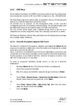
Direct-To Navigation using the G3X Touch
The Direct-to method of navigation, initiated by pressing the Direct-to Key
is quicker to use than a flight plan when the desire is to navigate to a single
point such as a nearby airport.
Once a direct-to is activated, the G3X Touch establishes a point-to-point
course line from the present position to the selected direct-to destination.
Course guidance is provided until the direct-to is replaced with a new
direct-to or flight plan, or cancelled.
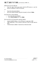
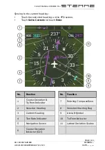
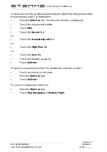
To enter a waypoint identifier, facility name, or city as a direct-to
destination:
•
Press the Direct-to Key. The Direct-to Window is displayed.
•
Touch the waypoint identifier.
•
Enter the waypoint identifier using the keypad and touch Enter.
or:
•
Touch Find > Search Name > Search by Facility Name. Enter the
facility name using the keypad and touch Enter.
or:
•
Touch Find > Search City > Search by City. Enter the city name
using the keypad and touch Enter.
•
Touch Activate.
Summary of Contents for G3X Touch
Page 1: ......

