Map Pages
3-55
Chart Extent Box
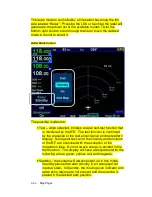
A green chart extent box is drawn separately on the map and
represents the geographic boundaries of an instrument approach
plate associated with a FMS destination. When the ownship
symbol crosses the boundary of the chart extent box, this is a
good time to switch over to the CHART tab.
Close Up of Chart Extent Box
Hot Links to Charts
Hot links to the charts directory or individual charts exist in
several locations throughout the IFD including the FPL tab, INFO
tab and NRST tab of the FMS page.
COOL FEATURE
Hot Links to Charts in Flight Plan
Whenever a
flight plan leg (blue airfield legs) has at least one
published approach associated with it, a chart icon
is presented on the right edge of the flight plan leg.
By using touch or the bottom right IFD knob, scroll
through the flight plan elements until the chart icon
Summary of Contents for IFD540
Page 1: ......
Page 2: ......
Page 8: ......
Page 82: ...2 28 FMS Pages Approaches Dropdown Box Procedures Brackets ...
Page 91: ...2 37 FMS Pages Four Additional Rows of Weather Data on Info Tab Info Tab Nearby Navaids ...
Page 101: ...2 47 FMS Pages User Waypoint Airfield Depiction on Map ...
Page 154: ...3 50 Map Pages Curved Flight Path with Next Leg Depiction Fly By Waypoint Depiction 1 ...
Page 156: ...3 52 Map Pages Missed Approach Enabled in Map SVS View ...
Page 260: ......
Page 332: ......


