Map View
175
9. Map View
Map View is a unique feature that allows the user to graphically view the survey path and any
flags or interpretations added. This is helpful in determining the linearity and consistency of
buried objects.
A common use of this feature is to snake back and forth over a given area. Each time you cross
a target producing a hyperbola, click on the top of the hyperbola to add an interpretation. If the
object is a linear feature (such as a pipe), all the interpretations will line up when viewed in Map
View.
Map View is only available if GPS data is collected with the GPR data. It is the GPS that is
used to position lines and/or grids correctly.
If you use the internal GPS, only grid data will be shown in Map View. If an external GPS is
connected, both line and grid data will be shown.
9.1 Accessing Map View
Map View is project-based and displays all grids and lines collected in a project. A project will
typically contain all the data collected at a given site.
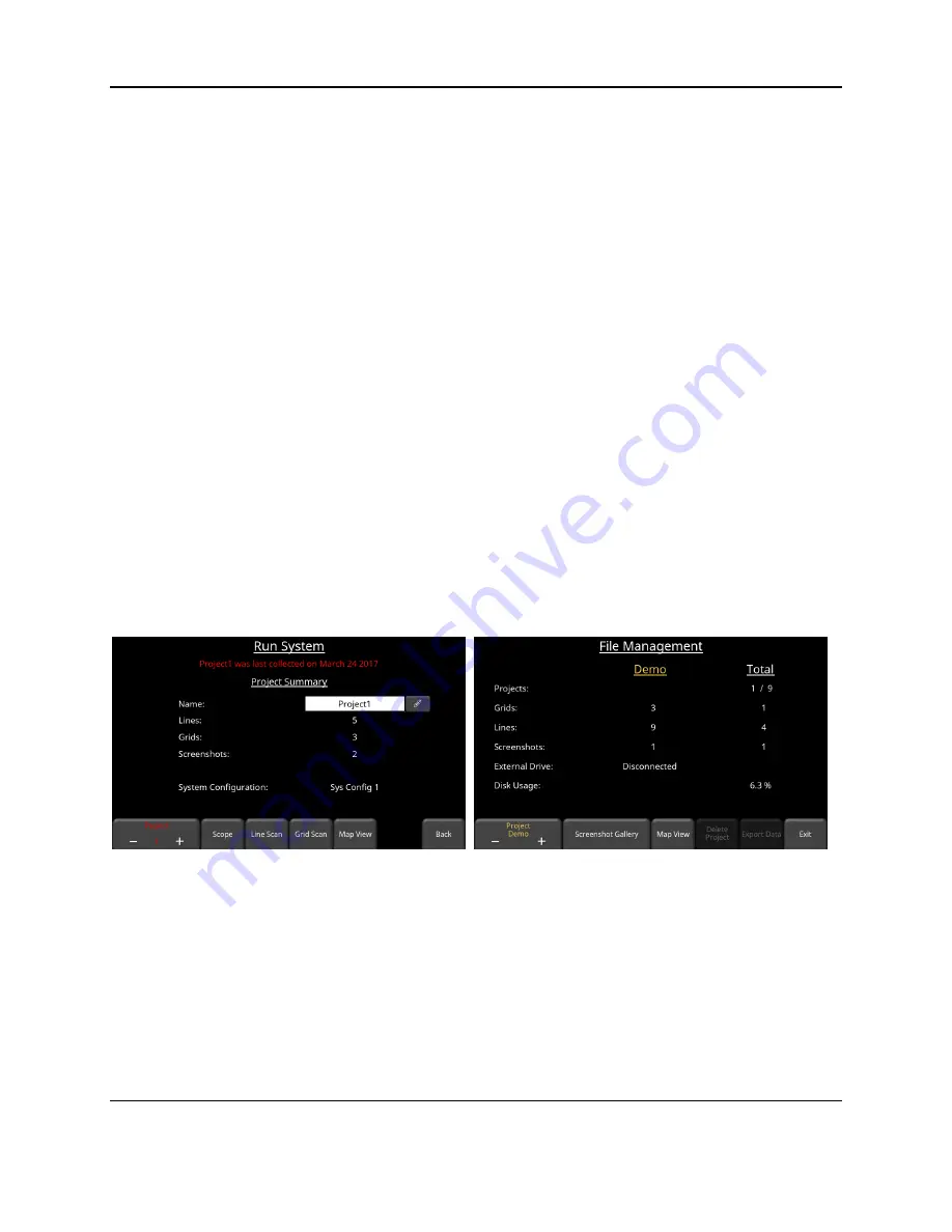
Map View can be accessed either from the
Run System
screen (Figure 7-1) or from the
File
Management
menu (Figure 9-1). The
Map View
button is only available if data exists in the
project AND it was collected with the GPS enabled; otherwise it will be greyed out.
Figure 9-1: Accessing Map View either from the Run System screen (left) or File Management menu (right)
Irrespective of how you get there, entering
Map View
shows an image similar to Figure 9-2.
Dragging your finger around the screen moves the entire map around, and can be used for
centering the map. Pressing the
+
and
–
buttons under the
Zoom
button zoom in and out of the
image. The scale is shown in the bottom corners in US Standard (bottom left) and Metric
(bottom right) units.
Содержание pulseEKKO
Страница 1: ...2005 00040 09 ...
Страница 2: ...ii ...
Страница 4: ...Warranty Confirmation iv ...
Страница 10: ...x ...
Страница 14: ...Introduction 2 ...
Страница 72: ...Assembling Full Configurations 60 ...
Страница 80: ...Getting Started 68 ...
Страница 116: ...Tools and Preferences 104 ...
Страница 180: ...Collecting Data 168 ...
Страница 185: ...Slice View 173 Figure 8 4 Varying the Grid Lines from top to bottom ON PARTIAL and OFF settings ...
Страница 190: ...Map View 178 ...
Страница 198: ...Managing Data 186 ...
Страница 221: ...Care Maintenance 209 ...
Страница 222: ...Care Maintenance 210 ...
Страница 226: ...Technical Specifications 214 ...
Страница 228: ...Appendix A 216 ...
Страница 234: ...Appendix B 222 ...
Страница 236: ...Appendix C 224 ...
Страница 238: ...Appendix D 226 ...
Страница 246: ...Appendix E 234 ...
Страница 248: ...Appendix F 236 ...
Страница 250: ...Appendix G 238 ...