


5-4
hsb
2
Plus Series Fishfinders
D
ispl
ay
ing Ch
art
Obj
ect
a
nd So
ur
ce
In
for
m
ati
on
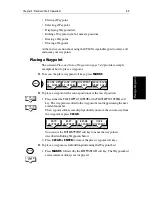
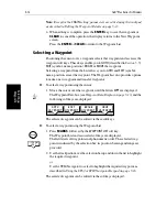
The boundary of each chart digitized in the current card is defined by a box or
rectangle. (You can switch off the chart boundaries display if you wish, as part
of the chartplotter set up described in
Section 7.5
.)
➤
To zoom in:
1. Use the trackpad to move the cursor inside one of the chart boxes, and press
the lower part of the
RANGE
key.
That area is expanded, with the cursor at the center, so that you can see
more detail. Note that the smaller the chart box is on the screen, the further
you can zoom in and the greater the amount of detail that is available.
If you have switched on Plotter Mode (see
Section 7.5
), you can zoom in
further than the most detailed chart; all chart functions remain available.
Displaying Chart Object and Source Information
Chart cards include a number of displayed objects for which information is
available, such as lights and buoys. They also contain additional source data
for structures, lines, open sea areas etc. You can use the context-sensitive
cursor to identify (in a pop-up box) an object or chart position and you can
obtain detailed information for the selected item.
Set up options let you specify when an identification pop-up is displayed;
three options are available:
•
Display a pop-up for
all
objects and source data automatically when the
cursor is over the object symbol or source area.
•
Display a pop-up for displayed objects when the cursor is over the symbol.
•
Do not display the identification pop-ups.
The chartplotter also provides information for the nearest waypoint, port
facility, tide station, wreck or obstruction for a selected position. If your chart
includes port and tide data, this can be displayed.
➤
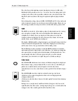
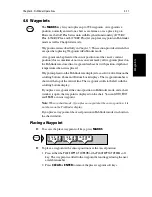
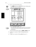
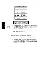
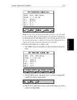
To identify and item and obtain detailed information:
1. Move the cursor over the symbol or chart position for which you require
the information. If specified in Chart Set Up, a pop-up box such as the fol-
lowing is displayed at the lower left or upper right corner of the screen:
2. To view detailed information, press
ENTER
. The details available are listed
on-screen in an object information pop-up.
The pop-up is split into two windows; objects are listed in the upper win-
RANGE
D4260-2
1 Object
FAIRWAY BN Bn Safe Water RW
LFI.W.10s7m5M
Содержание hsb2 PLUS
Страница 1: ...hsb2 PLUS Series Fishfinders Owner s Handbook Document number 81195_2 Date August 2002...
Страница 2: ......
Страница 34: ...1 22 hsb2 Plus Series Fishfinders Database Lists...
Страница 64: ...2 30 hsb2 Plus Series Fishfinders Transmitted Data...
Страница 110: ...4 14 hsb2 Plus Series Fishfinders MOB...
Страница 160: ...5 50 hsb2 Plus Series Fishfinders Review Your Passage Plan...
Страница 172: ...6 12 hsb2 Plus Series Fishfinders Data Log Mode...
Страница 200: ...8 8 hsb2 Plus Series Fishfinders Worldwide Support...
Страница 204: ...A 4 hsb2 Plus Series Fishfinders Appendix A Specifications...
Страница 216: ...C 6 hsb2 Plus Series Fishfinders Appendix C C MAP Chart Card Features...
Страница 228: ...viii hsb2 Plus Series Fishfinders...