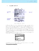
3.2 Data eld Elements
Data eld elements can be used to shown numerical information like altitude, vertical speed, speed, glide
ratio, and many others.
These elements have congurable size, and position, although the text within has only 3 possible sizes.
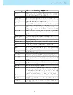
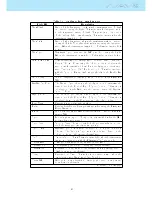
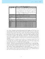
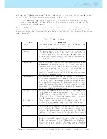
The folowing table explains the available data elds. As the NAV SD rmware evolves this list will likely
grow.
Table 3.4: Data elds Description
Field ID
Description
A.OverGoal
Altitude over goal is the dierence between the current altitude
and the goal's altitude based on barometric pressure values.
Above To
Altitude above takeo is the altitude over the ight starting point.
Abs.Pressure
Absolute atmospheric pressure value in Pascals.
Active waypoint
Active turnpoint name.
AirTemp.
Air Temperature as measured by the wireless speed probe.
Alt.Gain
Altitude Gain. Altitude gained in current thermal.
Alt.Gain/Loss
Altitude Gain/Loss. When at the top of the thermal displays the
altitude gained from the base of the thermal, else displays the
altitude lost since reaching the top of thermal.
Alt.to CTR
Altitude to CTR shows altitude to controller airspace, a negative
number indicates we must sink to come out of controlled airspace.
Altitude
Current altitude. This altitude is calculated based on the baro-
metric pressure and depends on the QNH value.
Altitude2
Second Altimeter which can be set independently to the main
altimeter.
Arrival Goal
Estimated arrival height above Goal. The height is calculated
considering the average glide ratio that has being made. This
means that wind, day quality and glider performance are used in
the calculations.
Arrival Next
Estimated arrival height above the next waypoint. This means
that wind, day quality and glider performance are used in the
calculations.
Ave.Speed
Average ground speed calculated using a lter to show a smoothed
speed, eliminating erratic speed changes due to glider pitching,
etc.
Ave.Vario
Average Vario calculated using an integration time constant in
order to indicate smoother climbing rates.
AveROT
Average rate of turn in degrees per second.
Battery
Shows battery strength as a percentage of complete charge
Bearing
Current bearing in degrees.
Ceiling
Shows the upper altitude of the airspace causing the warning, i.e.
airspace that you are violating or close to violating.
ConeVSpd
The minimum thermal speed which compensates stop to climb
instead of going straight to the Conical End of Speed Section.
CTR Name
Name of the airspace causing warning or violation.
CTR Status
Status message of airspace, will show Violating when in controlled
airspace, Immenent Alt when close to entering airspace vertically
or Pos.Immenent when close to entering airspace horizontally.
Cur.G.R.
Current glide ratio calculated using the average vario value, and
average ground speed.
Date
Current date. This value is automatic set when the device gets a
valid GPS Signal
Continued on next page
17
Содержание Flymaster NAV SD
Страница 1: ...User manual Version 3 0...
Страница 54: ...Figure 4 42 GPS Reset 53...
Страница 66: ...Figure 9 2 Firmware Update Done 65...

